|
Diciembre de 2011
The 2011 Tohoku-Oki Earthquake: Displacement Reaching the
Trench Axis
Author: Paul S. P. Cowpertwait et al
Link: Click here
Abstract
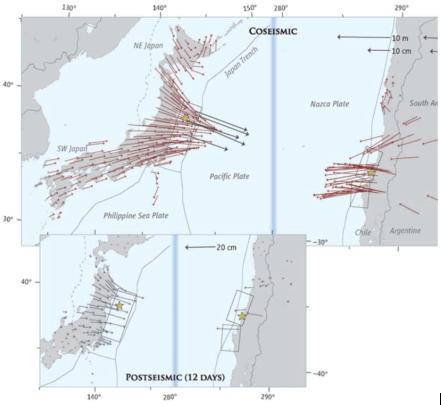
We detected and measured coseismic displacement caused by
the 11 March 2011 Tohoku-Oki earthquake [moment magnitude
(MW) 9.0] by using multibeam bathymetric surveys. The difference
between bathymetric data acquired before and after the earthquake
revealed that the displacement extended out to the axis of
the Japan Trench, suggesting that the fault rupture reached
the trench axis. The sea floor on the outermost landward area
moved about 50 meters
|
horizontally east-southeast and ~10 meters
upward. The large horizontal displacement lifted the sea floor
by up to 16 meters on the landward slope in addition to the
vertical displacement.
The large tsunami that followed the 11 March
2011 Tohoku-Oki earthquake [moment magnitude (MW) 9.0] is
believed to have been caused by a fault rupture extending
to a shallow part of the subduction zone at the Japan Trench.
This is indicated by various seismic and geodetic inversion
procedures. However, an accurate up-dip limit of the coseismic
displacement has not yet been determined. We report repeated
multibeam bathymetric surveys across the trench in the rupture
zone before and after the earthquake to estimate its up-dip
limit and quantify sea-floor displacement.
|
|
Diciembre de 2011
Un método de regionalización basado en un
modelo de agrupación probabilístico
Autor: Paul S. P. Cowpertwait
Link: Clic aquí
Abstract
En este paper se propone un método basado en un modelo
de agrupación probabilístico (modelo Gaussiano
multivarido mixto) para agrupar sitios en regiones contiguas
homogéneas sin superposición definidas por una
teselación de Voronoi (polígonos Theisson).
El modelo de agrupación probabilístico es aplicado
a las propiedades de segundo orden estándar de la muestra
anual (media, coeficiente de variación, y autocorrelación)
evaluados en el nivel diario de la agregación de cada
una de 234 registros de precipitación diaria en ciertos
lugares ubicados en el País Vasco, España. Utilizando
el criterio de información bayesiano, nuestro método
identifica cuatro grupos (que no se encuentran en regiones
contiguas). Además, calculamos las distancias entre
todos los pares de vecinos de los sitios conectados por bordes
de la gráfica plana de Delaunay. La probabilidad de
que un sitio que pertenece a cada uno de los cuatro grupos
se calcula a partir del ajuste del modelo Gaussiano y se multiplica
con la probabilidad de que el sitio de vecinos pertenezca
a la misma categoría. Estos productos se dividen por
el cuadrado de la distancia entre los sitios y se suman para
obtener un parámetro global que mide el grado de pertenencia
de un sitio dentro de los cuatro grupos. Las regiones de la
teselación de Voronoi de los puntos se clasifican sobre
la base de este parámetro y en función del hecho
de si están espacialmente aisladas de otras regiones
de la misma clase. Los puntos que tienen la menor influencia
en la variación de los errores residuales del modelo
ajustado se encuentran utilizando un criterio basado en el
parámetro lambda de Wilks para el análisis multivariante
de la varianza, y las clases de los restantes puntos de influencia
se ajustan para asegurar que las regiones sean contiguas.
|
Diciembre de 2011
A regionalization method based on a cluster probability model
Author: Paul S. P. Cowpertwait
Link: Click here
Abstract
A regionalization method based on a cluster probability model
(a mixed multivariate Gaussian model) is proposed for grouping
sites into nonoverlapping contiguous homogeneous regions defined
by a Voronoi tessellation (Theisson polygons). The cluster
probability model is applied to second-order standardized
annual sample properties (mean, coefficient of variation,
and autocorrelation) evaluated at the daily level of aggregation
taken from each of 234 daily rainfall records with positions
located in the Basque Country, Spain. Using the Bayesian information
criterion, four clusters of sites are identified (which do
not fall into contiguous regions). The distances between all
neighboring pairs of sites connected by edges from the Delaunay
planar graph are found. The probability that a site belongs
to each of the four clusters is extracted from the fitted
Gaussian model and multiplied into the probability that the
neighboring site belongs to the same cluster. These products
are divided by the squared distance between the sites and
are summed to give an overall measure of a site belonging
to a cluster that takes into account the classification of
neighboring sites. Regions from the Voronoi tessellation of
the points are classed on the basis of this measure and according
to whether they are spatially isolated from other regions
of the same class. Points that have the least influence on
the variance of residual errors of the fitted model are found
using a criterion based on Wilks' lambda for multivariate
analysis of variance, and the classes of the least influential
points are adjusted to ensure the overall regions are contiguous.
|
|
Diciembre de 2011
First ionospheric images of the seismic fault slip on the
example of the Tohoku-oki earthquake
Authors: Elvira Astafyeva, Philippe Lognonné et al
Link: Click here
Abstract
1Hz GPS measurements from the Japanese GPS network GEONET
allowed to retrieve information on the seismic fault of the
great M9.0 Tohoku-oki earthquake from the ionosphere total
electron content (TEC) measurements. The first arrival of
the TEC perturbation was registered 464 seconds after the
earthquake ~140 km on the east from the epicenter. Within
next 45 seconds the distribution of ionospheric points imaged
a rectangular area (37.39 - 39.28°N; 142.8 - 143.73°E),
which coincides with the area of the coseismic crustal
|
uplift.
From this source region, the coseismic ionospheric perturbation
further propagated at 1.3-1.5 km/s. Such velocity values are
30-40% higher than previously reported for acoustic waves. It
is likely that we observed shock-acoustic waves propagating
at supersonic speed and having blown all the electrons available
between the ground and the height of detection. This fact is
coherent with registration of the first arrival of perturbation
464 sec after the earthquake that is, generally speaking, too
short time for a regular acoustic wave to reach the ionosphere.
Our findings show that the real-time GPS monitoring of seismo-active
areas could inform about the parameters of coseismic crustal
displacements and can be, subsequently, used for short-term
tsunami warnings. In the case of the 03/11/2011 earthquake,
the first ionosphere perturbations were registered ~17 minutes
before the tsunami arrived on the east coast of Honshu. |
|
Diciembre de 2011
Radiación de energía dependiente de la frecuencia
y acoplamiento de falla para los terremotos 2010 Mw8.8, Chile
y 2011 Mw9.0 Tohoku, Japón
Autores: Dun Wang and Jim Mori
Link: Clic
aquí
Abstract
Hemos calculado nuevas proyecciones de los datos filtrados
telesísmicamente en diferentes bandas de frecuencia
para los terremotos 2010 Mw8.8, Chile y 2011 Mw9.0 Tohoku,
Japón. Para el terremoto de Maule se enontraron diferencias
a lo largo de la huelga de la falla con la energía
de alta frecuencia, principalmente procedentes de un área
de 200 kilómetros al noreste del epicentro, al tiempo
que la energía de baja frecuencia provenía de
un lugar más cercano al epicentro. El terremoto de
Tohoku muestra fuertes dependencias de la frecuencia en la
dirección de la fosa. Se encontraron fuentes de alta
frecuencia a unos 100 kilómetros al oeste del epicentro,
mientras que las fuentes de baja frecuencia se encontraron
alrededor de epicentro, es decir, cerca de la Fosa de Japón.
En este paper se comparan las distribuciones espaciales de
la energía con las estimaciones de acoplamiento sísmica
realizadas antes de los terremotos. Parece ser que se encuentran
zonas de radiación de alta frecuencia relacionadas
con las regiones que se vieron fuertemente afectadas antes
de los terremotos. Las áreas de alto acoplamiento pueden
estar asociadas con propiedades de las fallas que son más
heterogéneas y / o con estrés en general más
altos, produciendo así una mayor frecuencia para las
ondas sísmicas.
|
Diciembre de 2011
Frequency-dependent energy radiation and fault coupling for the 2010 Mw8.8 Maule, Chile, and 2011 Mw9.0 Tohoku, Japan, earthquakes
Authors: Dun Wang and Jim Mori
Link: Click here
Abstract
We carried out back-projections of teleseismic data filtered in different frequency bands for the 2010 Maule, Chile and the 2011 Tohoku, Japan earthquakes. For the Maule earthquake, there were differences along strike of the fault, with the high-frequency energy mainly originating from an area 200 km northeast of the epicenter, whereas low-frequency energy came from a location closer to the epicenter. The Tohoku earthquake shows strong frequency dependence in the dip direction. High-frequency sources were located about 100 km west of the epicenter, while low-frequency sources were around epicenter, near the Japan Trench. We compare the spatial distributions of energy with estimates of seismic coupling before the earthquakes. Areas of high-frequency radiation seem correlated with regions that were strongly coupled before the earthquakes. Areas of high coupling, may be associated with fault properties that are more heterogeneous and/or have overall higher stress, producing higher frequency seismic waves.
|
|
Diciembre de 2011
The 2010 Haiti earthquake: A complex fault pattern constrained
by seismologic and tectonic observations
Authors: Bernard Mercier de Lépinay, Anne Deschamps
et al
Link: Click here
Abstract
After the January 12, 2010, Haiti earthquake, we deployed
a mainly offshore temporary network of seismologic stations
around the damaged area. The distribution of the recorded
aftershocks, together with morphotectonic observations and
mainshock analysis, allow us to constrain a complex fault
pattern in the area. Almost all of the aftershocks have a
N-S compressive mechanism, and not the expected left-lateral
strike-slip mechanism. A first-order slip model of the mainshock
shows a N264°E north-dipping plane, with a major left-lateral
component and a strong
|
reverse
component. As the aftershock distribution is sub-parallel and
close to the Enriquillo fault, we assume that although the cause
of the catastrophe was not a rupture along the Enriquillo fault,
this fault had an important role as a mechanical boundary. The
azimuth of the focal planes of the aftershocks are parallel
to the north-dipping faults of the Transhaitian Belt, which
suggests a triggering of failure on these discontinuities. In
the western part, the aftershock distribution reflects the triggering
of slip on similar faults, and/or, alternatively, of the south-dipping
faults, such the Trois-Baies submarine fault. These observations
are in agreement with a model of an oblique collision of an
indenter of the oceanic crust of the Southern Peninsula and
the sedimentary wedge of the Transhaitian Belt: the rupture
occurred on a wrench fault at the rheologic boundary on top
of the under-thrusting rigid oceanic block, whereas the aftershocks
were the result of the relaxation on the hanging wall along
pre-existing discontinuities in the frontal part of the Transhaitian
Belt. |
|
Diciembre de 2011
Estimates of stress drop and crustal tectonic stress from
the 27 February 2010 Maule, Chile, earthquake: Implications
for fault strength
Authors: Karen M. Luttrell, Xiaopeng Tong et al
Link: Click here
Abstract
The great 27 February 2010 Mw 8.8 earthquake off the coast
of southern Chile ruptured a 600 km length of subduction zone.
In this paper, we make two independent estimates of shear
stress in the crust in the region of the Chile earthquake.
First, we use a coseismic slip model constrained by geodetic
observations from interferometric synthetic aperture radar
(InSAR) and GPS to derive a spatially variable estimate of
the change in static shear stress along the ruptured fault.
Second, we use a static force balance model to constrain the
crustal shear stress required to simultaneously support observed
fore-arc topography and the stress orientation indicated by
the earthquake focal mechanism. This includes the derivation
of a semianalytic solution for the
|
stress field exerted
by surface and Moho topography loading the crust. We find that
the deviatoric stress exerted by topography is minimized in
the limit when the crust is considered an incompressible elastic
solid, with a Poisson ratio of 0.5, and is independent of Young's
modulus. This places a strict lower bound on the critical stress
state maintained by the crust supporting plastically deformed
accretionary wedge topography. We estimate the coseismic shear
stress change from the Maule event ranged from -6 MPa (stress
increase) to 17 MPa (stress drop), with a maximum depth-averaged
crustal shear-stress drop of 4 MPa. We separately estimate that
the plate-driving forces acting in the region, regardless of
their exact mechanism, must contribute at least 27 MPa trench-perpendicular
compression and 15 MPa trench-parallel compression. This corresponds
to a depth-averaged shear stress of at least 7 MPa. The comparable
magnitude of these two independent shear stress estimates is
consistent with the interpretation that the section of the megathrust
fault ruptured in the Maule earthquake is weak, with the seismic
cycle relieving much of the total sustained shear stress in
the crust. |
|
Noviembre de 2011
Inter event times of fluid induced earthquakes suggest
their Poisson nature
Authors:C. Langenbruch, C. Dinske et al
Link: Click here
Abstract
We analyze the inter event time distribution of fluid-injection-induced
earthquakes for six catalogs collected at geothermal injection
sites at Soultz-sous-Forêts and Basel. We find that
the distribution of waiting times during phases of constant
seismicity rate coincides with the exponential distribution
of the homogeneous Poisson process (HPP). We analyze the waiting
times for the complete event catalogs and find
|
that,
as for naturally occurring earthquakes, injection induced earthquakes
are distributed according to a non homogeneous Poisson process
in time. Moreover, the process of event occurrence in the injection
volume domain is a HPP. These results indicate that fluid-injection-induced
earthquakes are directly triggered by the loading induced by
the fluid injection. We also consider the spatial distance between
events and perform a nearest neighbor analysis in the time-space-magnitude
domain. Our analysis including a comparison to a synthetic catalog
created according to the ETAS model reveals no signs of causal
relationships between events. Therefore, coupling effects between
events are very weak. The Poisson model seems to be a very good
approximation of fluid induced seismicity. |
|
Noviembre de 2011
China to Spend Billions Cleaning Up Groundwater
Author: Jane Qiu
Link: Click here
Abstract
On 28 October, China's State Council unveiled a $5.5 billion
initiative over 10 years to prevent and treat groundwater
contamination. The plan will bolster monitoring and push development
of groundwater cleanup technologies. The project is long overdue,
hydrologists say. Water is scarce in China, which ekes by
with only one-quarter of the global average for water per
capita. Roughly 70% of Chinese get their drinking water from
underground-and the economic boom of the past few decades
has tainted much of that supply, hydrologists say. Disasters
like the petrochemical plant explosions in 2005 that spilled
100 tons of benzene and other chemicals into the Songhua River
near the Russian border have exacerbated China's woes.
|
As Li Wenpeng traveled
in rural China over the past decade to assess groundwater quality,
he encountered a grim reality. In many villages he visited,
locals were drawing water from contaminated wells and rivers.
"It's often the only water source available," says
Li, chief engineer with the China Institute of Geo-Environmental
Monitoring in Beijing. "You have places where the entire
village is sick" with diarrhea or cancers of the digestive
tract, he says.
The Chinese government is about to throw these villages a lifeline.
On 28 October, the State Council unveiled a $5.5 billion initiative
over 10 years to prevent and treat groundwater contamination.
The plan will bolster monitoring and push development of groundwater
cleanup technologies.
The project is long overdue, hydrologists say. Water is scarce
in China, which ekes by with only one-quarter of the global
average for water per capita. Roughly 70% of Chinese get their
drinking water from underground-and the economic boom of the
past few decades... |
|
Noviembre de 2011
Analysis of laboratory simulations of volcanic hybrid earthquakes
using empirical Green's functions
Authors: Rebecca M. Harrington and Philip M. Benson
Link: Click here
Abstract
Here we present a new analysis of experimental simulations
of the seismic signals characteristically observed in volcanic
environments. We examine the waveforms of laboratory microseismic
events generated during two rock deformation experiments performed
on samples of Mt. Etna basalt to determine their source characteristics
and establish evidence for a mode of failure. Events were
recorded during deformation under (a), unsaturated (dry) conditions,
and (b), samples saturated with water. We employ an empirical
Green's function approach to isolate the acoustic emission
event source spectra from attenuation and travel path effects,
and estimate the spectral corner frequency using a least squares
fit to a Brune spectral model. Spectral fits indicate that
the acoustic emission events occurring under dry conditions
follow the expected scaling of moment
|
and corner frequency for standard brittle-failure
in an elastic medium with constant stress drop, namely M0
fc-3. However, the events occurring during the fluid decompression
phase of the saturated experiment have estimated corner frequencies
which are not easily described by any simple scaling relationship.
The implication of the observed scaling is that the events
occurring under dry conditions must result from a standard
stick-slip (i.e., brittle-failure) source. The observed moment-corner
frequency scaling also suggests that event durations change
in a predictable way with increasing moment for the events
occurring under dry conditions. Conversely, events occurring
under wet conditions do not show any distinctive relationship
between duration and event size. The specific dependence of
duration on event size exhibited by the events in the dry
experiment must consequently rule out fluid-flow as a source,
as there is no plausible reason for the driving pressure for
fluid-flow to be dependent on duration in such a specific
way. We compare laboratory observations of brittle-failure
scaling (M0 fc-3) to previous observations of volcanic hybrid
events in a field environment. Scaling dissimilarities between
field observations and the wet laboratory events suggest that
hybrid seismic signals observed in a volcanic environment
do not always require fluid-flow to explain their signal.
|
|
Noviembre de 2011
3D modeling of the cycle of a great Tohoku-oki earthquake,
considering frictional behavior at low to high slip velocities
Authors: B. Shibazaki, T. Matsuzawa et al
Link: Click here
Abstract
We perform 3D quasi-dynamic modeling of the cycle of a megathrust
earthquake in the offshore Tohoku region, Japan, using a rate-
and state-dependent friction law with two state variables
that exhibits strong velocity weakening at high slip velocities.
We set several asperities where velocity weakening occurs
at low to intermediate
|
slip
velocities. Outside of the asperities, velocity strengthening
occurs at low to intermediate slip velocities. At high slip
velocities, strong velocity weakening with large displacements
occurs both within and outside of the asperities. The rupture
of asperities occurs at intervals of several tens of years,
whereas megathrust events occur at much longer intervals (several
hundred years). Megathrust slips occur even in regions where
velocity strengthening occurs at low to intermediate slip velocities,
but where velocity weakening is dominant at high slip velocities.
The proposed model explains that megathrust earthquakes occur
in the same subduction zone as large thrust earthquakes. |
|
Octubre de 2011
Observations of Earth's toroidal free oscillations with
a rotation sensor: The 2011 magnitude 9.0 Tohoku-Oki earthquake
Authors: Heiner Igel, Maria-Fernanda Nader et al
Link: Click here
Abstract
We report for the first time observations of Earth's toroidal
free oscillations recorded on a ring laser system that is
sensitive to rotational ground motions around a vertical axis.
Because of the high noise level on the horizontal translational
components in classical seismometers, long-
|
period toroidal modes
are amongst the most challenging observations in seismology.
In addition, pure uncontaminated observations of long-period
motions are difficult as translational sensors are sensitive
to rotational motions also. We show that the toroidal modes
associated with rotational motions are complementary to those
associated with translations and confirm the relatively spatially
compact character of the Mw 9.0 Tohoku-Oki earthquake. The observations
presented here complement the translational, strain, and gravitational
records. We expect these observations to provide additional
constraints on long-wavelength deep Earth structure and earthquake
sources. |
|
Octubre de 2011
Rupture process of the 9 March, 2011 Mw 7.4 Sanriku-Oki,
Japan earthquake constrained by jointly inverting teleseismic
waveforms, strong motion data and GPS observations
Authors:Guangfu Shao, Chen Ji et al
Link: Click here
Abstract
The slip history of the 2011 Mw 7.4 Sanriku-Oki, Japan earthquake,
which occurred fifty-one hours before the Mw 9.1 Tohoku earthquake,
is constrained by jointly inverting waveforms of teleseismic
body waves, long period surface waves and local strong motions
as well as GPS observations, after first relocating its hypocenter
using a double difference approach and teleseismic P waves.
The inverted results indicate that the rupture of this Sanriku-Oki
earthquake
|
was dominated by the failure of an elliptical shape asperity,
elongating roughly along the plate motion direction. The rupture
initiated at the southeast corner of this asperity and propagated
mainly in the west-northwest direction with a rupture velocity
of 3.1 km/s in the beginning 15 s and 1.1 km/s in the next 40
s. It released a total seismic moment of 1.6 × 10²⁰ Nm,
with 82% occurring in the first 25 s. The rupture had an average
slip of 1 m and produced an average stress drop of 0.9 MPa.
The Sanriku-Oki earthquake did not break the hypocenter region
of the Mw 9.1 Tohoku earthquake but slightly increased the Coulomb
stress there. A correlation between the high slip region and
the high Vp/Vs ratio of the overriding plate right above the
plate interface has been found, which suggests the Sanriku-Oki
earthquake and its frequent predecessors might have broken a
relatively weaker patch within a large strongly coupled asperity.
|
|
Octubre de 2011
Tsunami source of the 2011 Tohoku-Oki earthquake, Japan:
Inversion analysis based on dispersive tsunami simulations
Authors: Tatsuhiko Saito, Yoshihiro Ito et al
Link: Click here
Abstract
The large tsunami of the 2011 Tohoku-Oki earthquake was clearly
recorded by the ocean bottom pressure and GPS wave gauges
deployed in and around Japan. We estimated the initial tsunami
water height distribution by inversion analysis of the waveforms
based on dispersive
|
tsunami simulations.
The distribution is characterized by a peak height of 8 m located
near the trench and the high-water (>2m) region extending
landward with a width of ~100 km. A series of numerical simulations
suggests that a relatively steep peak located near the trench
is necessary in order to simultaneously reproduce the dispersive
wave at a far-field station and the near-field waveforms. Furthermore,
we estimated the coseismic slip distribution at the plate boundary,
which indicates that large slip (~30 m) occurred at a depth
of 20 km, which corresponds to a large slip deficit area in
the interseismic period. Another slip (~25 m) occurred at the
shallower part (<10 km) during the rupture. |
|
Octubre de 2011
Compressive sensing of the Tohoku-Oki Mw 9.0 earthquake:
Frequency-dependent rupture modes
Authors: Huajian Yao, Peter Gerstoft et al
Link: Click here
Abstract
Compressive sensing (CS) is a technique for finding sparse
signal representations to underdetermined linear measurement
equations. We use CS to locate seismic sources during the
rupture of the 2011 Tohoku-Oki Mw9.0 earthquake
|
in Japan from teleseismic
P waves recorded by an array of stations in the United States.
The seismic sources are located by minimizing the l2-norm of
the difference between the observed and modeled waveforms penalized
by the l1-norm of the seismic source vector. The resulting minimization
problem is convex and can be solved efficiently. Our results
show clear frequency-dependent rupture modes with high-frequency
energy radiation dominant in the down-dip region and low-frequency
radiation in the updip region, which may be caused by differences
in rupture behavior (more intermittent or continuous) at the
slab interface due to heterogeneous frictional properties. |
|
Octubre de 2011
Evidence of Water Vapor in Excess of Saturation in the
Atmosphere of Mars
Authors: L. Maltagliati, F. Montmessin et al
Link: Click here
Abstract
The vertical distribution of water vapor is key to the study
of Mars' hydrological cycle. To date, it has been explored
mainly through global climate models because of a lack of
direct measurements. However, these models assume the absence
of supersaturation in the atmosphere of Mars. Here, we report
observations made using the SPICAM (Spectroscopy for the Investigation
of the Characteristics of the Atmosphere of Mars) instrument
onboard Mars Express that provide
|
evidence of the frequent presence of water
vapor in excess of saturation, by an amount far surpassing
that encountered in Earth's atmosphere. This result contradicts
the widespread assumption that atmospheric water on Mars cannot
exist in a supersaturated state, directly affecting our long-term
representation of water transport, accumulation, escape, and
chemistry on a global scale.
The atmosphere of Mars holds 10,000 times
less water vapor than that of Earth. If precipitated at the
surface, the martian atmospheric water would form a layer
only 10 um thick on average. However, water vapor on Mars
is a very dynamic trace gas and is one of the most variable
atmospheric constituents...
|
|
Octubre de 2011
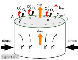
Ionosphere plasma bubbles and density variations induced
by pre-earthquake rock currents and associated surface charges
Authors: C. L. Kuo, J. D. Huba et al
Link: Click here
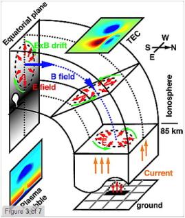
Abstract
Recent ionospheric observations indicate that the total electron
content (TEC) may anomalously
|
decrease or increase
up to 5-20% before the occurrence of big earthquakes. The ionospheric
density variations can be caused by earth surface charges/currents
produced from electric currents associated with the stressed
rock. We formulate a coupling model for the stressed rock-Earth
surface charges-atmosphere-ionosphere system. The stressed-rock
acts as the dynamo to provide the currents for the coupling
system. The electric fields and currents in the atmosphere and
the lower boundary of ionosphere are obtained by solving the
current continuity equation, o J = 0, where J is the current
density. A three-dimensional ionosphere simulation code is then
used to study the ionospheric dynamics based on the obtained
electric fields and currents. The simulation results show that
a current density Jrock = 0.2-10 µA/m2 in an earthquake
fault zone is required to cause daytime TEC variations of 2-25%.
The simulation results also show that a current density Jrock
= 0.01-1 µA/m2 can lead to nighttime TEC variations of
1-30% as well as the formation of a nighttime plasma bubble
(equatorial spread F) extending over the whole magnetic flux
tube containing the earthquake epicenter. We suggest that observations
of daytime and nighttime TEC variations and a nighttime plasma
bubble within the affected region can be used as precursors
for earthquake prediction. |
|
|
 |
|
Octubre de 2011
Evidence of large scale repeating slip during the 2011
Tohoku-Oki earthquake
Authors: Shiann-Jong Lee, Bor-Shouh Huang et al
Link: Click here
Abstract
The repetition of slip during rupture process of earthquake
is a debate issue which had never been confirmed clearly in
the past big events due to the lack of dense near-field observations
and limited resolution in time of source model. The 2011 M9.0
Tohoku-Oki earthquake generated a wealth seismic records which
provided us an unprecedented opportunity to study the rupture
evolution of giant earthquake at a high spatio-temporal resolution.
Here we use teleseismic, local strong motion and near-field
coseismic
|
geodetic data to investigate
the source rupture process of this event based on the parallel
inversion technique. The results reveal a broad slip zone with
remarkable large scale repeating slip during the earthquake.
The inverted source model shows several time periods of energy
release with three main peaks. These energy bursts and temporal
rupture snapshots suggest repetition of a large scale slip on
the biggest asperity. This rupture behavior resulted in >50
m slips on the slip zone and prolonged the entire rupture process
for a long duration of ~160 seconds. The proposed source model
is in a good agreement with the aftershock distribution and
can interpret the characteristics of local strong motions. Further
investigations of repeating slip during this event are crucial
which will deeply transform earthquake science from dynamic
point of view. |
|
Octubre de 2011
Precursory seismic quiescence before the Mw = 8.3 Tokachi-oki,
Japan, earthquake on 26 September 2003 revealed by a re-examined
earthquake catalog
Author: Kei Katsumata
Link: Click here
Abstract
The 2003 Tokachi-oki earthquake (Mw = 8.3) occurred on 26
September 2003 off the pacific coast of Hokkaido, Japan. In
the present study, an earthquake catalog is used that lists
2,000 earthquakes with M = 3.3. All of the earthquake waveforms
were recorded by the Institute of Seismology and Volcanology,
Hokkaido University. In the present study, these waveforms
are manually re-examined, and hypocenters and magnitudes are
re-calculated. A detailed analysis of the re-determined earthquake
catalog between 1994 and 2003 using a gridding technique (ZMAP)
|
shows
that the 2003 Tokachi-oki earthquake is preceded by two neighboring
seismic quiescence anomalies that start around the beginning
of 1999, and last about 5 years, until the main shock occurs.
These quiescence anomalies are located around the asperity ruptured
by the main shock, and the Z-values are +3.9 and +4.0 for a
time window of Tw = 4 years, using a sample size of N = 100
earthquakes. The detected seismic quiescences can be interpreted
as being caused by a decrease of 50% in the stressing rate based
on Dieterich's theory. It is proposed that a quasi-static pre-slip
occurs at the northeastern edge of the asperity ruptured by
the main shock, and lasts for five years until the main shock
occurs. By calculating the change in the Coulomb failure stress
(DELTA CFS), it is found that negative DELTA CFS areas are consistent
with the two quiescence anomalies, and a positive DELTA CFS
area corresponds to the hypocenter of the main shock, indicating
that the quasi-static pre-slip model is a plausible one. |
|
Octubre de 2011
Thermal control of the seismogenic zone of southern central
Chile
Authors: David Völker, Ingo Grevemeyer et al
Link: Click here
Abstract
We developed thermal models for the Chile subduction zone
along two profiles at 38.2°S and 42°S within the rupture
area of the 1960 M = 9.5 Valdivia earthquake and south of
the 2010 M = 8.8 Maule earthquake. The age difference of the
subducting Nazca Plate has a major impact on the thermal regime,
being much younger and hotter in the south. Seafloor heat
flow observations confirm this difference but also indicate
that in the southern area, heat advection at the outer rise
cools the incoming plate. Heat
|
flow values derived
from the depth of gas hydrate bottom-simulating reflectors are
in general agreement with probe and borehole measurements. The
positions where the plate interface reaches temperatures of
100-150°C and 350-450°C differ between the two profiles.
If these temperatures control the updip and downdip limits of
the interplate seismogenic zone, the seismogenic zone widens
and shifts landward to greater depths from south to north. Observed
microseismicity, however, seems to fade at temperatures much
lower than 350-450°C. This discrepancy can be explained
in three alternative ways: (1) deformation in a thick subduction
channel controls the seismic/aseismic transition; (2) microseismicity
recorded over a limited time period does not represent the rupture
depth of large interface earthquakes; or (3) the serpentinized
mantle wedge controls the downdip limit. |
|
Octubre de 2011
GRACE gravity data help constraining seismic models of
the 2004 Sumatran earthquake
Authors: G. Cambiotti, A. Bordoni et al
Link: Click here
Abstract
The analysis of Gravity Recovery and Climate Experiment (GRACE)
Level 2 data time series from the Center for Space Research
(CSR) and GeoForschungsZentrum (GFZ) allows us to extract
a new estimate of the co-seismic gravity signal due to the
2004 Sumatran earthquake. Owing to compressible self-gravitating
Earth models, including sea level feedback in a new self-consistent
way and designed to compute gravitational perturbations due
to volume changes separately, we are able to prove that the
asymmetry in the co-seismic gravity pattern, in which the
north-eastern negative anomaly is twice as large as the south-western
positive anomaly, is not due to the previously overestimated
dilatation in the crust. The overestimate was due to a large
dilatation localized at the fault discontinuity, the gravitational
effect of which is compensated by an opposite contribution
from topography due to the uplifted crust. After this
|
localized
dilatation is removed, we instead predict compression in the
footwall and dilatation in the hanging wall. The overall anomaly
is then mainly due to the additional gravitational effects of
the ocean after water is displaced away from the uplifted crust,
as first indicated by de Linage et al. (2009). We also detail
the differences between compressible and incompressible material
properties. By focusing on the most robust estimates from GRACE
data, consisting of the peak-to-peak gravity anomaly and an
asymmetry coefficient, that is given by the ratio of the negative
gravity anomaly over the positive anomaly, we show that they
are quite sensitive to seismic source depths and dip angles.
This allows us to exploit space gravity data for the first time
to help constraining centroid-momentum-tensor (CMT) source analyses
of the 2004 Sumatran earthquake and to conclude that the seismic
moment has been released mainly in the lower crust rather than
the lithospheric mantle. Thus, GRACE data and CMT source analyses,
as well as geodetic slip distributions aided by GPS, complement
each other for a robust inference of the seismic source of large
earthquakes. Particular care is devoted to the spatial filtering
of the gravity anomalies estimated both from observations and
models to make their comparison significant. |
|
Octubre de 2011
Flash Heating Leads to Low Frictional Strength of Crustal
Rocks at Earthquake Slip Rates
Authors: David L. Goldsby and Terry E. Tullis
Link: Click here
Abstract
The sliding resistance of faults during earthquakes is a critical
unknown in earthquake physics. The friction coefficient of
rocks at slow slip rates in the laboratory ranges from 0.6
to 0.85, consistent with measurements of high stresses
|
in Earth's crust.
Here, we demonstrate that at fast, seismic slip rates, an extraordinary
reduction in the friction coefficient of crustal silicate rocks
results from intense "flash" heating of microscopic
asperity contacts and the resulting degradation of their shear
strengths. Values of the friction coefficient due to flash heating
could explain the lack of an observed heat flow anomaly along
some active faults such as the San Andreas Fault. Nearly pure
velocity-weakening friction due to flash heating could explain
how earthquake ruptures propagate as self-healing slip pulses. |
|
Septiembre de 2011
The dynamics of a seismic wave field: Animation and analysis
of kinematic GPS data recorded during the 2011 Tohoku-oki
earthquake, Japan
Authors: Ronni Grapenthin and Jeffrey T. Freymueller
Link: Click here
Abstract
During rupture, earthquakes induce permanent and dynamic ground
displacements that can be measured by GPS. More than 1200
continuous GPS stations distributed throughout Japan recorded
the displacements due to the March 11, 2011, Mw9.0 Tohoku-oki
earthquake. We animate these data, which shows the growth
of the earthquake rupture over time and illustrates
|
differences of earthquake
magnitude through two smaller aftershocks. We also identify
dynamic ground motion due to S-waves (body waves), Love waves
and Rayleigh waves (surface waves) in this data set. Real time
availability of such displacements could be of great use in
earthquake response and tsunami warning, and to some degree
in earthquake early warning. We find that the length of the
ruptured fault can be approximated from displacements which
could allow rapid identification of areas prone to large aftershocks.
We outline a method that integrates real time displacements
into an earthquake alarm system. The animated displacements
in map view are easily understandable by specialists and non-specialists
alike and hence provide a valuable education and outreach tool.
|
|
Septiembre de 2011
Coseismic gravity changes of the 2011 Tohoku-Oki earthquake
from satellite gravimetry
Authors: Koji Matsuo, Kosuke Heki
Link: Click here
Abstract
The massive Tohoku-Oki earthquake of a moment magnitude (Mw)
of 9.0 occurred on 11 March, 2011 off the Pacific coast of
the Northeastern Japan. The mass redistribution in and around
the focal region associated with this earthquake was studied
using the gravity changes detected by Gravity Recovery and
Climate Experiment (GRACE) satellite. After the 2004 Sumatra-
|
Andaman
and the 2010 Central Chile (Maule) earthquakes, the present
study presents the third case of clear detection of coseismic
gravity changes by GRACE. The observed gravity changes were
dominated by decrease over the back-arc region of aprox 7 uGal
or less. This reflects, to a large extent, coseismic crustal
dilatation of the landward plate. They agree well with the changes
calculated with the Green's function for the realistic earth
using fault parameters inferred from coseismic crustal movements.
The spatial patterns of the gravity changes of these earthquakes
are very similar because they are all shallow angle reverse
faulting at convergent plate boundaries. We found linear relationship
between gravity decreases and seismic moments. |
|
Septiembre de 2011
Dielectric signatures of adsorbed and salty liquid water
at the Phoenix landing site, Mars
Authors: David E. Stillman and Robert E. Grimm
Link: Click here
Abstract
The real part of the dielectric permittivity of the Martian
regolith was measured by the Thermal and Electrical Conductivity
Probe (TECP) on the Phoenix lander. We interpret these data
using laboratory measurements of permittivity as a function
of H2O and salt content, soil type, and temperature. Due to
variability in sensor coupling, we focus on data taken at
one locality ("Vestri") three separate times, spanning
multiple sols. A daytime increase in permittivity suggests
progressive melting of a heterogeneous, disconnected, salty
ice with a eutectic temperature
|
of
~239 K, which is close to the eutectic temperatures of NaClO4
or MgCl2. We found no evidence for Mg(ClO4)2. NaClO4 and MgCl2
are consistent with precipitation by freezing following a prior
epoch of high obliquity. The evaporation of diurnal briny meltwater
is inhibited by surface tension in small pores. An increase
in permittivity occurred on the night of sol 70 that coincided
with surface frost and measurement of a decrease in atmospheric
water vapor. The permittivity jump can be matched by an increase
in adsorbed H2O from ~1 monolayer to 3 monolayers in an analog
soil with a Viking-like specific surface area (17 m2/g). However,
the amount of adsorbed H2O is an order of magnitude larger than
that inferred to have precipitated during the night. We suggest
that the electrical signature of adsorbed water on Mars is stronger
than we measured in the laboratory, possibly due to radiation
damage of the regolith. |
|
|
|
Septiembre de 2011
Ionospheric electron enhancement preceding the 2011 Tohoku-Oki
earthquake
Author: Kosuke Heki
Link: Click here
Abstract
The 2011 March 11 Tohoku-Oki earthquake (Mw9.0) caused vast
damages to the country. Large events beneath dense observation
networks could bring breakthroughs to seismology and geodynamics,
and here I report one such finding. The Japanese dense network
of
|
Global Positioning
System (GPS) detected clear precursory positive anomaly of ionospheric
total electron content (TEC) around the focal region. It started
~40 minutes before the earthquake and reached nearly ten percent
of the background TEC. It lasted until atmospheric waves arrived
at the ionosphere. Similar preseismic TEC anomalies, with amplitudes
dependent on magnitudes, were seen in the 2010 Chile earthquake
(Mw8.8), and possibly in the 2004 Sumatra-Andaman (Mw9.2) and
the 1994 Hokkaido-Toho-Oki (Mw8.3) earthquakes, but not in smaller
earthquakes. |
|
Septiembre de 2011
Impact of CO2 geological sequestration on the nucleation
of earthquakes
Authors: Frédéric Cappa and Jonny Rutqvistl
Link: Click here
Abstract
Can CO2 storage cause earthquakes? What is the maximum possible
earthquake magnitude resulting from CO2 injection? Here, as
a theoretical case study we investigate these questions using
coupled hydromechanical modeling with multiphase flow and
seismological variables for quantifying earthquake magnitude
and energy. Our simulations consider transient fluid flow
and stress coupling, and the evolution of
|
fault
properties. We simulate CO2 injection into a reservoir-caprock
system bounded by a subvertical normal fault subjected to different
extensional stress regimes and over a range of initial fault
permeability values. For our assumed system and injection rate,
the simulation results show that sudden stress drop and fault
slip primarily initiated along the fault portion intersecting
the storage reservoir after a few months of injection when a
sufficiently high reservoir pressure has been reached. The size
of the rupture area, and consequently, the earthquake magnitude
and energy, depends on initial horizontal-to-vertical stress
ratio and fault permeability, which strongly influences the
size of the pressurized area, and subsequent stress variations.
|
|
|
|
Septiembre de 2011
Principal horizontal stress orientations prior to the 2011
Mw 9.0 Tohoku-Oki, Japan, earthquake in its source area
Authors: Weiren Lin, Saneatsu Saito et al
Link: Click here
Abstract
We determined principal horizontal stress orientations as
of 1999 at sites in the source area of the 2011 Mw 9.0 Tohoku-Oki
earthquake, on the deep-sea terrace of the Japan Trench. The
maximum principal horizontal stress orientation at site 1151
of Ocean Drilling Program Leg 186,
|
located in an aseismic
zone, was east-southeast, parallel with the plate convergence
direction; and the stress orientation at site 1150 of Leg 186,
in a seismically active zone, was south-southeast, suggestive
of a local stress feature due to the influence of seismic activity.
Aftershocks with normal faulting mechanisms, observed in the
hanging wall of the plate interface that ruptured during the
Tohoku-Oki earthquake, indicate a normal faulting postseismic
stress regime, which clearly differs from the stress state prior
to the earthquake. Consequently, the stress state may have changed
from a reverse to a normal faulting stress regime during the
Tohoku-Oki earthquake sequence. |
|
Septiembre de 2011
Distribution and abundance of gas hydrates in near-surface
deposits of the Håkon Mosby Mud Volcano, SW Barents
Sea
Authors: Thomas Pape, Tomas Feseker et al
Link: Click here
Abstract
The occurrence of gas hydrates at submarine mud volcanoes
(MVs) located within the gas hydrate stability zone (GHSZ)
is controlled by upward fluid and heat flux associated with
MV activity. Determining the spatial distribution of gas hydrates
at MVs is crucial to evaluate their sensitivity to known episodic
changes in volcanic activity. We determined the hydrocarbon
inventory and spatial distribution of hydrates at an individual
MV structure. The Håkon Mosby Mud Volcano (HMMV), located
at 1,250 m water depth on the Barents Sea slope, was investigated
by combined
|
pressure core sampling,
heat flow measurements, and pore water chemical analysis. Quantitative
pressure core degassing revealed gas-sediment ratios between
3.1 and 25.7, corresponding to hydrate concentrations of up
to 21.3% of the pore volume. Hydrocarbon compositions and physicochemical
conditions imply that gas hydrates incipiently crystallize as
structure I hydrate, with a dissociation temperature of around
13.8°C at this water depth. Based on numerous in situ measurements
of the geothermal gradient in the seabed, pore water sulfate
profiles and microbathymetric data, we show that the thickness
of the GHSZ increases from less than 1 m at the warm center
to around 47 m in the outer parts of the HMMV. We estimate the
total mass of hydrate-bound methane stored at the HMMV to be
about 102.5 kt, of which 2.8 kt are located within the morphological
Unit I around the center and thus are likely to be dissociated
in the course of a large eruption. |
|
Septiembre de 2011
Evaluating predictions of ICME arrival at Earth and Mars
Authors: T. V. Falkenberg, A. Taktakishvili et al
Link: Click here
Abstract
We present a study of interplanetary coronal mass ejection
(ICME) propagation to Earth and Mars. Because of the significant
space weather hazard posed by ICMEs, understanding and predicting
their arrival and impact at Mars is important for current
and future robotic and manned missions to the planet. We compare
running ENLILv2.6 with coronal mass ejection (CME) input parameters
from both a manual and an automated method. We analyze shock
events identified at Mars in Mars Global Surveyor data in
2001 and 2003, when Earth and Mars were separated by <80°
in heliocentric longitude. The shocks identified at Mars were
also identified at Earth, and the
|
majority
of the shock sources were identified through the Solar and Heliospheric
Observatory-Large Angle and Spectrometric Coronagraph catalogue.
We find that arrival times predicted by the two methods at both
planets are statistically similar, dynamic pressures predicted
when using the automated method are better, and the automated
method tends to underestimate both CME width and speed. Using
the location of the related flare as the CME direction did not
improve results. In addition, changing the CME speed toward
the plane-of-sky speed at 20 RS improves the match to observations,
mainly because the speed found by the automated method is underestimated.
The time lapse between the shock arrival at Earth and Mars,
for the events studied here, is shorter than expected from simulations,
and the presence of high speed streams can enable an ICME to
arrive almost simultaneously at Earth and Mars. This work will
be applied to improve the input parameter methods for ENLIL.
|
|
Septiembre de 2011
Titan at the edge: 1. Titan's interaction with Saturn's
magnetosphere in the prenoon sector
Authors: D. Snowden, R. Winglee et al
Link: Click here
Abstract
The characteristics of Titan's environment at 09:00 Saturn
local time (SLT) are studied using a three-dimensional multifluid/multiscale
model of Titan embedded in a global model of Saturn's magnetosphere
for three cases: a stationary magnetopause, an inward moving
magnetopause, and an outward moving magnetopause. The results
show that the plasma and magnetic field upstream of Titan
are variable and that the variability can be enhanced when
Saturn's magnetopause is not stationary. Rotating cold, interchange
fingers cause rapid changes in
|
the plasma velocity,
density, and composition, while gradual changes are due to the
relatively slow compression and expansion of Saturn's magnetopause.
Titan enters a boundary layer on the inside of Saturn's magnetopause
when Saturn's magnetopause compresses. The boundary layer is
characterized by shearing flows and a mix of magnetospheric
and magnetosheath plasma. The irregular flows in the boundary
layer strongly modify Titan's induced magnetosphere. The results
indicate that more ions from Titan are lost from Saturn's magnetosphere
during parallel interplanetary magnetic field (IMF) than antiparallel
IMF. In addition, we find that Titan's ion tail may be able
to prevent the magnetopause from crossing Titan when Titan is
in the prenoon sector. Therefore, despite a large increase in
solar wind pressure, Titan remained inside of Saturn's magnetosphere.
A synthetic trajectory through the simulation is shown to be
consistent with magnetometer data from the TA flyby. |
|
Septiembre de 2011
Statistics of multifractal processes using the maximum
entropy method
Authors: V. Nieves, J. Wang et al
Link: Click here
Abstract
We have demonstrated that the maximum entropy
|
(ME)
principle can be used as a general inference algorithm to derive
the probability distributions at different scales of a multifractal
process characterized by its scaling properties such as multiscaling
moments and geometric mean. In a case study, the ME distributions
of topography have been tested using wavelet analysis. |
|
Septiembre de 2011
Ocean wave sources of seismic noise
Authors: Fabrice Ardhuin, Eleonore Stutzmann et al
Link: Click here
Abstract
Noise with periods 3 to 10 s, ubiquitous in seismic records,
is expected to be mostly generated by pairs of ocean wave
trains of opposing propagation directions with half the seismic
frequency. Here we present the first comprehensive numerical
model of microseismic generation by random ocean waves, including
ocean wave reflections. Synthetic and observed seismic spectra
are well correlated (r > 0.85). On the basis of the model
results, noise generation events can be clustered in three
broad classes: wind waves with a broad directional spectrum
(class I), sea states with a significant contribution
|
of coastal reflections
(class II), and the interaction of two independent wave systems
(class III). At seismic stations close to western coasts, noise
generated by class II sources generally dominates, but it is
intermittently outshined by the intense class III sources, limiting
the reliability of seismic data as a proxy for storm climates.
The modeled seismic noise critically depends on the damping
of seismic waves. At some mid-ocean island stations, low seismic
damping is necessary to reproduce the observed high level and
smoothness of noise time series that result from a spatial integration
of sources over thousands of kilometers. In contrast, some coastal
stations are only sensitive to noise within a few hundreds of
kilometers. This revelation of noise source patterns worldwide
provides a wealth of information for seismic studies, wave climate
applications, and new constraints on the possible directional
distribution of wave energy. |
|
Septiembre de 2011
Inversion of high-rate (1 sps) GPS data for rupture process
of the 11 March 2011 Tohoku earthquake (Mw 9.1)
Authors: H. Yue and T. Lay
Link: Click here
Abstract
The space-time fault displacement history of the 11 March
2011 Tohoku (Mw 9.1) megathrust earthquake is obtained by
least-squares inversion of high-rate (1 sample per second)
GPS ground motions recorded in Japan. Complete near-source
time-varying and static ground motions for periods =25 s are
fit in the inversion using a
|
normal
mode formalism to compute the Green functions. The basic rupture
pattern is stable for various choices of model parameters and
solution smoothing, and excellent fits to the complete seismo-geodetic
ground motions are obtained. The preferred solution has concentrations
of slip near the trench and hypocenter, with sub-fault source
time function durations of ~30-70 s and maximum slip of ~60
m. Down-dip slip spreads over a wider area with smaller maximum
slip (<~10-15 m). Inversion of the high-rate GPS data exploits
both the timing and total displacement information in the ground
motions, yielding stable estimates of the seismic moment (~4.8
× 1022 Nm; Mw = 9.1) and slip distribution. |
|
Septiembre de 2011
Timescales of alluvial fan development by precipitation
on Mars
Authors: John J. Armitage, Nicholas H. Warner et al
Link: Click here
Abstract
Dozens of large, low-gradient alluvial fans are present within
impact crater basins on the cratered highlands of Mars. The
timescales and climate conditions that were required to generate
such fans are unknown, but testable through our understanding
of terrestrial hill slope erosion in the presence of precipitation.
Previous estimates of fan formation time vary from years to
millions of years. Here, we use an idealised physical model
of 2-D catchment-fan evolution to present a
|
framework within which
the development of Martian alluvial fans should be considered.
We simplify the erosional and depositional system so that there
are only three variables: erodibility due to gravity, amount
of water runoff due to precipitation, and catchment-fan boundary
elevation. Within this framework, to generate large, low-gradient
(<6°) alluvial fans on Mars requires significant periods
of erosion due to runoff. We suggest two climate scenarios,
either: (1) rates of precipitation that are similar to arid
terrestrial climates over timescales of 107 to 108 yr or (2)
a shorter duration of semiarid to temperate climate conditions
over a period on the order of 106 yr. Hyper-arid conditions
generate low-gradient alluvial fans under conditions of a topographically
lowered fan-catchment boundary and only over timescales >108
yr if the substrate is extremely erodible relative to terrestrial
examples. |
|
Agosto de 2011
Generation mechanism of slow earthquakes: Numerical analysis
based on a dynamic model with brittle-ductile mixed fault
heterogeneity
Authors: Ryoko Nakata, Ryosuke Ando et al
Link: Click here
Abstract
Various characteristics have been discovered for small, slow
earthquakes occurring along subduction zones, which are deep
nonvolcanic tremor, low-frequency earthquakes (LFEs), and
very low frequency earthquakes (VLFs). In this study, we model
these slow earthquakes using a dynamic model consisting of
a cluster of frictionally unstable patches on a stable background.
The controlling parameters in our model are related to the
patch distribution and the viscosity of both the patches and
the background.
|
By
decreasing patch density or increasing viscosity, we observed
the transition in rupture propagation mechanism, that is, from
fast elastodynamic interactions characterized by an elastic
wave propagation to slow diffusion limited by viscous relaxation
times of traction on fault patches and/or background. Some sets
of these geometrical and frictional parameters collectively
explain the moment rate functions, source spectra, and scaled
energy of observed slow earthquakes. In addition, we successfully
explain both parabolic and constant velocity migrations in the
case of the diffusion-limited rupture. Therefore, the observed
various characteristics of tremor, LFEs, VLFs, and, potentially,
slow slip events, may be essentially explained by our simple
model with a few parameters describing source structures and
frictional properties of brittle-ductile transition zones along
plate boundaries. |
|
Agosto de 2011
Ionospheric density variations recorded before the 2010
Mw 8.8 earthquake in Chile
Authors: D. Píša, M. Parrot et al
Link: Click here
Abstract
We present a study of plasma density variations observed by
the DEMETER spacecraft in the vicinity of a very powerful
earthquake in Chile. This earthquake of moment magnitude 8.8
occurred on 27 February 2010 with an epicenter located at
|
35.85°S, 72.72°W. Data recorded 10-20 days before
the main shock along orbits close to the future epicenter
show increasing plasma densities. In a second step, a statistical
analysis with DEMETER data has been performed using the first
3 months of the years 2007-2010 to monitor density variations
in the vicinity of the epicenter at the same local time and
seasonal conditions. This study shows that a large increase
of the plasma density is very uncommon at this location and
at this time and that the increases observed during the days
before the main shock could be considered as possible short-term
precursors of this powerful earthquake.
|
|
Agosto de 2011
Ghost tilt signal during transient ground surface deformation
events: Insights from the September 3, 2010 Mw7.1 Darfield
earthquake, New Zealand
Authors: Nicolas Fournier, Arthur D. Jolly et al
Link: Click here
Abstract
This work assesses whether tiltmeters can reliably measure
ground tilt in the 2-20 s band, similar to that of very-long
period volcanic earthquakes. Seismic waves recorded with co-located
high-rate GPS, borehole seismometer and bubble tiltmeter during
the 2010 Mw7.1
|
Darfield
earthquake in New Zealand are used to determine the response
of the tiltmeter. The joint analysis of this dataset shows that,
at least for periods within the aforementioned band, the observed
tilt signal was in fact not related to ground tilt but, instead,
to translational ground acceleration caused by passing S and
surface waves. If no independent control on translational motion
is provided for recorded very-long period volcanic earthquakes
within the 2-20 s band, the signal recorded on bubble tiltmeters
may therefore be misinterpreted. The use of co-located high-rate
GPS data provides such control and is essential to discriminate
translational motion from ground tilt on the recorded seismic
and tiltmeter signals. |
|
Agosto de 2011
Kohonen self-organizing map estimator for the reference
crop evapotranspiration
Authors: Adebayo J. Adeloye, Rabee Rustum et al
Link: Click here
Abstract
Reference crop evapotranspiration (ETo) estimation is of importance
in irrigation water management for the calculation of crop
water requirements and its scheduling, in rainfall-runoff
modeling and in numerous other water resources studies. Due
to its importance, several direct and indirect methods have
been employed to determine the reference crop evapotranspiration
but success has been limited because the direct measurement
methods lack in precision and accuracy due to scale issues
and other problems, while some of the more accurate indirect
methods, e.g., the Penman-Monteith benchmark model, are time-consuming
and require weather input data that are not routinely monitored.
This
|
paper has used the
Kohonen self-organizing map (KSOM), unsupervised artificial
neural networks, to predict the ETo. based on observed daily
weather data at two climatically diverse basins: a small experimental
catchment in temperate Edinburgh, UK and a semiarid lake basin
in Udaipur, India. This was achieved by using the powerful clustering
capability of the KSOM to analyze the multidimensional data
array comprising the estimated ETo (based on the Food and Agricultural
Organization (FAO) Penman-Monteith model) and different subsets
of climatic variables known to affect it. The findings indicate
that the KSOM-based ETo estimates even with fewer input variables
were in good agreement with those obtained using the conventional
FAO Penman-Monteith formulation employing the full complement
of weather data at the two locations. More crucially, the KSOM-based
estimates were also found to be significantly superior to those
estimated using currently recommended empirical ETo methods
for data scarce situations such as those in developing countries.
|

Kohonen self-organizing map estimator
for the reference crop evapotranspiration.
|
|
Agosto de 2011
Deep tremor in New Zealand triggered by the 2010 Mw8.8
Chile earthquake
Authors: B. Fry, K. Chao et al
Link: Click here
Abstract
Deep non-volcanic tremor (NVT) is usually associated with
episodic slow-slip events. New Zealand is one notable exception
where numerous slow slip events have been identified, yet
NVT has remained undetected. Here we present the first known
case of triggered NVT at New Zealand's Hikurangi subduction
margin. Following the Mw8.8 Chilean earthquake of
|
February
27, 2010, we identify coherent high-frequency tremor signals
that are in phase with, and modulated by, the passing Rayleigh
waves. This is consistent with the surface wave triggering potential
for strike-normal incidence on a low-angle thrust fault. After
constraining the tremor depth on the plate interface, we locate
the tremor source within 20 km of the source area of episodic
slow slip. The tremor location is also near the edge of a region
with high seismic attenuation that marks the boundary between
dehydrated subducted slab and inferred hydrated, underplated
sediment. We speculate that reduced interface friction and high
fluid pressures provided by fluid-rich underplated sediment
facilitates the tremor generation. |
|
Agosto de 2011
ON THE DETERMINISTIC DESCRIPTION OF EARTHQUAKES
Author: Andrea Bizzarri
Link: Click here
Abstract
The quantitative estimate of earthquake damage due to ground
shaking is of pivotal importance in geosciences, and its knowledge
should hopefully lead to the formulation of improved strategies
for seismic hazard assessment. Numerical models of the processes
occurring during seismogenic faulting represent a powerful
tool to explore realistic scenarios that are often far from
being fully reproduced in laboratory experiments because of
intrinsic, technical limitations. In this paper we discuss
the prominent role of the fault governing model, which describes
the behavior of the fault traction during a dynamic slip failure
and accounts for the different, and potentially competing,
chemical and physical dissipative mechanisms. We show in a
comprehensive sketch the large number of constitutive models
|
adopted in dynamic
modeling of seismic events, and we emphasize their prominent
features, limitations, and specific advantages. In a quantitative
comparison, we show through numerical simulations that spontaneous
dynamic ruptures obeying the idealized, linear slip-weakening
(SW) equation and a more elaborated rate- and state-dependent
friction law produce very similar results (in terms of rupture
times, peaks slip velocity, developed slip, and stress drops),
provided that the frictional parameters are adequately comparable
and, more importantly, that the fracture energy density is the
same. Our numerical experiments also illustrate that the different
models predict fault slip velocity time histories characterized
by a similar frequency content; a feeble predominance of high
frequencies in the SW case emerges in the frequency ranges [0.3,
1] and [11, 50] Hz. These simulations clearly indicate that,
even forgiving the frequency band limitation, it would be very
difficult (virtually impossible) to discriminate between two
different, but energetically identical, constitutive models,
on the basis of the seismograms recorded after a natural earthquake.
|
|
Julio de 2011
La Industria Geotérmica Estadounidense impulsa nuevas
investigaciones
University of Nevada, Reno
Link: Click aquí
Abstract
La energía geotérmica y la industria relacionada
con ella podrían tomar un nuevo impulso en Estados
Unidos, en función de las conclusiones que se extraigan
de un proceso de investigación desarrollado por la
Universidad de Nevada, en Reno, en colaboración con
el Departamento de Energía estadounidense. El propósito
de este estudio es comprender y caracterizar el potencial
geotérmico de cerca de 500 sitios ubicados a lo largo
de la denominada “Gran Cuenca” de Nevada.
Mediante el análisis de 463 lugares con posibilidades
de ser explotados en el área de Nevada, Estados Unidos
busca darle un nuevo impulso a la industria geotérmica.
Esta fuente energética ha merecido un ambicioso plan
de estudios e investigaciones desarrollado por la Universidad
de Nevada y el Departamento de Energía del país.
|
Julio de 2011
Geothermal Industry to Get Boost from New Research
University of Nevada, Reno
Link: Click here
Abstract
An ambitious University of Nevada, Reno project to understand
and characterize geothermal potential at nearly 500 sites
throughout the Great Basin is yielding a bounty of information
for the geothermal industry to use in developing resources
in Nevada, according to a report to the U.S. Department of
Energy.
The project, based in the University's Bureau of Mines and
Geology in the College of Science, is funded by a $1 million
DOE grant from the American Recovery and Reinvestment Act
of 2009. It has reached the one-year mark and is entering
phase two, when five or six of the 250 identified potentially
viable geothermal sites will be studied in more detail. Some
of the studied sites will even have 3-D imaging to help those
in the industry better understand geothermal processes and
identify where to drill for the hot fluids.
|
|
Julio de 2011
Rapid detection and characterization of large earthquakes
using quasi-finite-source Green's functions in continuous
moment tensor inversion
Authors: Aurélie Guilhem, Douglas S. Dreger et al
Link: Click here
Abstract
Large earthquakes along subduction zones have the potential
to generate tsunamis along local coasts, as well as traveling
far across oceans. By continuously inverting for moment tensors
we show that it is possible with a single procedure to
|
automatically detect,
locate and determine source parameters of any earthquake, from
magnitude 3.5 to larger than 8 located in both the near- and
far-field. We find that the detection and characterization of
large earthquakes is improved when quasi-finite-source Green's
functions are used in a point-source moment tensor approach
as they represent to some extent the rupture's finiteness and
directivity. Solutions can be obtained within several minutes
after the origin time of the earthquake, and could therefore
be used as part of a near-source tsunami early warning system,
capable of providing tens of minutes of possible warning depending
on the distance of the earthquake rupture from the coast. |
|
Julio de 2011
Upper crustal structure, seismicity and pore pressure variations
in an extensional seismic belt through 3-D and 4-D VP and
VP/VS models: The example of the Val d'Agri area (southern
Italy)
Authors: L. Valoroso, L. Improta et al
Link: Click here
Abstract
We use local earthquake tomography and background seismicity
to investigate static and transient features of the crustal
velocity structure in the Val d'Agri (southern Apennines,
Italy), one of the regions in central Mediterranean with the
highest seismogenic potential. The upper crust is dominated
by two broad high-velocity anticlines of the buried Apulia
Carbonate Platform ramping on two parallel high-angle thrusts
interpreted as preexisting inverted normal faults. The deep
core of the anticlines consists of very high VP (up to 6.9
km/s) and low VP/VS rocks, suggesting the involvement of the
Apulian crystalline basement in the Apennine belt. These results
provide valuable constraints on the Apennine belt tectonic
evolution, supporting a thick-skinned
|
by
an increase in permeability of over seven interpretation for
the Pliocene terminal phase of the compressional tectonics.
The geometry of the Val d'Agri Quaternary basin is controlled
by these inherited compressive features, whereas the presently
active extensional tectonics barely reworked the structure.
We find inconsistency between the structure of the Apulia Carbonate
Platform and the location and geometry of the Quaternary normal
faults mapped at the surface. This suggests either the immaturity
of the normal faults or their secondary role in accommodating
the extension. We observe spatiotemporal (4-D) changes of VP
and VP/VS models defining transient variations of pore fluid
pressure in the upper crust. A strong change in the VP/VS ratio
heralds a raise in the seismicity rate that can be related to
large water level changes in a nearby artificial lake. This
evidence is consistent with a mechanism of reservoir-induced
seismicity by fluid pressure increase and pore pressure diffusion.
The 4-D velocity variations are confined in the shallow portion
of the upper crust (3-6 km depth) where fluids are stored in
a highly fractured medium. Pore pressure fluctuations can affect
the strength of fault segments, favoring seismicity rate changes
along the active faults and possibly promoting large future
earthquakes. |
|
Julio de 2011
Numerical simulations of seismicity-induced fluid flow
in the Tjörnes Fracture Zone, Iceland
Authors: M. Lupi, S. Geiger et al
Link: Click here
Abstract
We use high-resolution simulations to analyze fluid flow,
pore pressure, and fault permeability evolution in the seismically
active Tjörnes Fracture Zone (TFZ), a major transform
fault zone in the North of Iceland. Our results show that
the TFZ is characterized by four distinct areas where pore
pressures are above hydrostatic, consistent with geophysical
observations. Basement and faults, which are assumed to have
low permeabilities, often display pore pressures close to
lithostatic. Fault permeabilities are allowed to vary freely
as a function of the effective fault normal stress. They hence
inflate periodically to release excess pore
|
pressure in a few
minutes. This is accompanied orders of magnitude and causes
short-lived fluid fluxes of more than 0.01 m s?1. After pore
pressures have dissipated, fault permeabilities decay back to
their original values in 2 to 3 years as the effective fault
normal stress increases. This behavior is consistent with a
toggle switch mechanism and could have two important implications
for fluid flow in seismically and hydrothermally active oceanic
crust. First, the rapid changes in fault permeability and pore
pressure provide an explanation for distinct cyclical geochemical
changes observed on a similar timescale in thermal waters near
the town of Húsavik in the TFZ before and after a magnitude
5.8 Mw earthquake. Second, our results provide another line
of evidence in the growing number of observations that crustal
permeabilities are constantly evolving and geological processes
in hydrothermal systems can be dominated by short-lived and
extreme flow events. |
|
Julio de 2011
Near-real-time forecasting of lava flow hazards during
the 12-13 January 2011 Etna eruption
Authors: A. Vicari, G. Ganci et al
Link: Click here
Abstract
Forecasting the lava flow invasion hazard in near-real time
is a primary challenge for volcano monitoring systems. The
paroxysmal episode at Mount Etna on 12-13 January 2011 produced
in 4 hours lava fountains and fast-moving lava flows 4.3 km
long. We produced timely predictions of the areas likely to
be inundated by lava flows
|
while the eruption was still ongoing. We employed infrared satellite
data (MODIS, AVHRR, SEVIRI) to estimate in near-real-time lava
eruption rates (peak value of 60 m3 s1). These time-varying
discharge rates were then used to drive MAGFLOW simulations
to chart the spread of lava as a function of time. Based on
a classification on durations and lava volumes of 130 paroxysms
at Etna in the past 13 years, and on lava flow path simulations
of expected eruptions, we constructed a lava flow invasion hazard
map for summit eruptions, providing a rapid response to the
impending hazard. This allowed key at-risk areas to be rapidly
and appropriately identified. |
|
Julio de 2011
Postseismic deformation in Pakistan after the 8 October
2005 earthquake: Evidence of afterslip along a flat north
of the Balakot-Bagh thrust
Authors: F. Jouanne, A. Awan et al
Link: Click here
Abstract
The 8 October 2005 Kashmir earthquake ruptured an out-of-sequence
Himalayan thrust known as the Balakot-Bagh thrust. The earthquake's
hypocenter was located at a depth of 15 km on the ramp close
to a possible ramp/flat transition. In the weeks following
the earthquake a GPS network was installed to measure postseismic
displacement. The initial measurements in November 2005 were
followed by other campaigns in January and August 2006, in
March and December 2007, and in August 2008 and 2009. Two
hypotheses were tested: post-seismic displacements controlled
by viscous relaxation of
|
the lower crust or
by afterslip along a flat north of the ramp affected by the
main shock. A single Newtonian viscosity for the different periods
cannot be determined by numerical simulations of viscous relaxation,
which may indicate that the viscosity of the lower crust is
non-Newtonian or that viscous relaxation does not control postseismic
displacements. Numerical simulations using dislocations in a
uniform elastic half-space indicate afterslip north of the ramp
of the earthquake along a flat connected to the ramp. Slip along
the northwestern portion of the flat accrued to about 285 mm
between November 2005 and August 2006, while slip along the
southeastern portion accrued to 130 mm over the same time period.
Residual misfit of the observed and predicted displacements
clearly indicated that afterslip is a better explanation for
the observations than the hypothesis of viscous relaxation.
The time evolution of the afterslip was found to be consistent
with that predicted from rate-strengthening frictional sliding.
|
|
Julio de 2011
The 2011 Magnitude 9.0 Tohoku-Oki Earthquake: Mosaicking
the Megathrust from Seconds to Centuries
Authors: Mark Simons, Sarah E. Minson et al
Link: Click here
Abstract
Geophysical observations from the 2011 moment magnitude (Mw)
9.0 Tohoku-Oki, Japan earthquake allow exploration of a rare
large event along a subduction megathrust. Models for this
event indicate that the distribution of coseismic fault slip
exceeded 50 meters in places. Sources of high-frequency seismic
waves delineate the edges of the deepest portions of coseismic
slip and do not simply correlate with the locations of peak
slip. Relative to the Mw 8.8 2010 Maule, Chile earthquake,
the Tohoku-Oki earthquake was deficient in high-frequency
seismic radiation-a difference that we attribute to its relatively
shallow depth. Estimates of total fault slip and surface secular
strain accumulation on millennial time scales suggest the
need to consider the potential for a future large earthquake
just south of this event.
|
|
|
Julio de 2011
El megaterremoto 8.8 Mw del año 2010, ocurrido en
el Maule, en la zona central de Chile, monitoreado por medio
de GPS
Autores: C. Vigny , A. Socquet et al
Link: Clic aquí
Abstract
Los grandes terremotos producen deformaciones de la corteza
terrestre que se pueden cuantificar mediante mediciones geodésicas,
lo que permite la determinación de la distribución
de deslizamientos en la falla. Se utilizaron los datos de
las redes del Sistema de Posicionamiento Global (GPS) del
centro de Chile para inferir la deformación estática
y cinemática de la magnitud de momento del megaterremoto
del Maule 8.8 Mw del año 2010. A partir del modelado
elástico, nos encontramos con una longitud de ruptura
total de ~ 500 kilómetros, donde el deslizamiento (de
hasta 15 metros) se concentró en dos principales asperezas
situados a ambos lados del epicentro. Hemos encontrado que
la ruptura llegó a aguas poco profundas y que probablemente
se extiende hasta la zanja. Los deslizamientos posteriores
ocurrieron en las regiones de bajo deslizamiento cosísmico.
La baja frecuencia hipocentral se trasladó 40 kilómetros
al suroeste de las estimaciones iniciales. La ruptura bilateral
se propagó a unos 3,1 kilómetros por segundo,
con posibles variaciones de la velocidad, pero este hecho
no se ha resuelto completamente.
|
Julio de 2011
The 2010 Mw 8.8 Maule Megathrust Earthquake of Central
Chile, Monitored by GPS
Authors: C. Vigny , A. Socquet et al
Link: Click here
Abstract
Large earthquakes produce crustal deformation that can be
quantified by geodetic measurements, allowing for the determination
of the slip distribution on the fault. We used data from Global
Positioning System (GPS) networks in Central Chile to infer
the static deformation and the kinematics of the 2010 moment
magnitude (Mw) 8.8 Maule megathrust earthquake. From elastic
modeling, we found a total rupture length of ~500 kilometers
where slip (up to 15 meters) concentrated on two main asperities
situated on both sides of the epicenter. We found that rupture
reached shallow depths, probably extending up to the trench.
Resolvable afterslip occurred in regions of low coseismic
slip. The low-frequency hypocenter is relocated 40 kilometers
southwest of initial estimates. Rupture propagated bilaterally
at about 3.1 kilometers per second, with possible but not
fully resolved velocity variations.
|
|
|
|
Junio de 2011
Full waveform tomographic images of the peak ring at the
Chicxulub impact crater
Authors: J. V. Morgan, M. R. Warner et al
Link: Clic here
Abstract
Peak rings are a feature of large impact craters on the terrestrial
planets and are generally believed to be formed from deeply
buried rocks that are uplifted during crater formation. The
precise lithology and kinematics of peak ring formation, however,
remains unclear. Previous work has revealed a suite of bright
inward dipping reflectors beneath the peak ring at the Chicxulub
impact crater and that the peak ring was formed from rocks
with a relatively low seismic velocity. New two-dimensional,
full waveform tomographic velocity images show that the uppermost
lithology of the peak ring is formed from a thin (~100-200
m
|
thick)
layer of low-velocity (~3000-3200 m/s) rocks. This low-velocity
layer is most likely composed of highly porous, allogenic impact
breccias. Our models also show that the change in velocity between
lithologies within and outside the peak ring is more abrupt
than previously realized and occurs close to the location of
the dipping reflectors. Across the peak ring, velocity appears
to correlate well with predicted shock pressures from a dynamic
model of crater formation, where the rocks that form the peak
ring originate from an uplifted basement that has been subjected
to high shock pressures (10-50 GPa) and lie above downthrown
sedimentary rocks that have been subjected to shock pressures
of <5 GPa. These observations suggest that low velocities
within the peak ring may be related to shock effects and that
the dipping reflectors underneath the peak ring might represent
the boundary between highly shocked basement and weakly shocked
sediments. |
|
|
|
Junio de 2011
Un cuento de dos terremotos
Autor: Kosuke Heki
Link: Clic aquí
Abstract
Miles de vidas fueron salvadas por "La Gran Alerta contra
Tsunamis" de Japón (los avisos de la Agencia Meteorológica
de Japón que siguieron al terremoto de Tohoku-Oki,
el 11 de marzo de 2011). Una alerta similar se gatilló
en la zona central de Chile (Maule), correspondiente al terremoto
del 27 de febrero de 2010. Comprender mejor cómo los
terremotos se desarrollan podría proporcionar sistemas
más eficaces de alerta temprana para ayudar a mitigar
el poder devastador de los terremotos. Cuatro artículos
de este número de Science, escritos por Sato et al.
en la página 1395 (1), Simons et al. en la página
1421 (2), Ide et al. en la página 1426 (3), y Vigny
et al. en la página 1417 (4), informan sobre estos
dos terremotos de magnitud 9 (M9), que ilustra el uso de las
redes del Sistema de Posicionamiento Global (GPS) para revelar
cómo los detectores ubicados en la superficie terrestre
detectan las deformaciones que ocurren durante y después
de los eventos sísmicos.
|
Julio de 2011
A Tale of Two Earthquakes
Author: Kosuke Heki
Link: Click here
Abstract
Thousands of lives were saved by the "Large Tsunami Warning"
announcements of the Japan Meteorological Agency that followed
the Tohoku-Oki earthquake of 11 March 2011. A similar alert
followed the Central Chile (Maule) earthquake on 27 February
2010. Understanding better how such earthquakes develop might
provide even more effective early-warning systems to help
mitigate their devastating power. Four papers in this issue-by
Sato et al. on page 1395 (1), Simons et al. on page 1421 (2),
Ide et al. on page 1426 (3), and Vigny et al. on page 1417
(4)-report on both of these magnitude 9 (M9) earthquakes,
illustrating the use of networks of Global Positioning System
(GPS) detectors to reveal how the Earth's surface deformed
during and after the events.
|
|
|
|
Junio de 2011
Stress changes and aftershock distribution of the 1994
and 2006 Java subduction zone earthquake sequences
Authors: Maya El Hariri and Susan L. Bilek
Link: Clic here
Abstract
The Mw = 7.8 1994 and the Mw = 7.7 2006 interplate thrust
mechanism earthquakes that occurred in the Java subduction
zone produced dominantly normal-faulting aftershocks, unusual
for large megathrust main shocks. Various models proposed
for these earthquake sequences invoke main shock rupture on
an isolated portion of a decoupled plate boundary fault, with
updip and outer-rise extension leading to the normal faulting.
Other models suggest that these aftershocks occurred in a
zone of the
|
subduction
zone where usually earthquakes cannot propagate or initiate,
leading to the occurrence of normal-faulting aftershocks in
the outer rise, overriding and subducting plates. Here we examine
a simpler possibility, one in which Coulomb stress changes (?CFS)
imparted by slip during the two large subduction events led
to normal-faulting events on favorably oriented planes within
the slab and near trench region of the subduction zone. We compute
stress changes resulting from both events and subsequent large
aftershocks using both uniform and variable slip models for
main shock slip, resolved onto both aftershock nodal planes.
We find that there is not a clear pattern of aftershock occurrence
in areas of stress increase due to main shock slip. This implies
that these aftershocks are not simply triggered by the static
stress changes from the main shock and additional complexity
should be considered to explain these unusual earthquake sequences.
|
|
Junio de 2011
Influence of pre-existing volcanic edifice geometry on
caldera formation
Author: V. Pinel
Link: Clic here
Abstract
Volcanic edifice construction at the Earth's surface significantly
modifies the stress field within the underlying crust with
two main implications for caldera formation. First, tensile
rupture at the Earth's surface is favored at the periphery,
which
|
enables ring fault
formation. Second, edifice formation amplifies the amount of
pressure decrease occurring within a magma reservoir before
the eruption stops. Taking into account both of these effects,
caldera formation can be initiated during a central eruption
of a pre-existing volcano even when assuming elastic behaviour
for the surrounding crust. Providing the roof aspect ratio is
small enough, conditions for caldera formation by reservoir
withdrawal can be reached whatever the reservoir shape is. However
ring fault initiation is easier for laterally elongated reservoirs.
|
|
Junio de 2011
Shear heating-induced thermal pressurization during earthquake
nucleation
Authors: S. V. Schmitt, P. Segall et al
Link: Clic here
Abstract
We model earthquake nucleation (in 2D) on narrow faults with
coupled rate-state friction and shear heating-induced thermal
pressurization, including diffusive transport of heat and
pore pressure. Thermal pressurization increases pore pressure
p, decreasing frictional resistance. Observed fault core permeability
is generally too low to mitigate thermal pressurization at
subseismic slip speeds. Under drained, isothermal conditions,
nucleation with the aging law is crack like, with the interior
of the slip zone always near maximum slip speed. When thermal
|
pressurization
is included, it can dominate weakening at speeds of 0.02-20
mm/s for hydraulic diffusivities chyd from 10-8 to 10-3 m2/s
and nominal material parameters well before seismic radiation
occurs. Dramatic along-strike localization of slip occurs due
to feedback in which the area of maximum slip experiences the
greatest weakening, which in turn favors more slip. With the
slip law, however, nucleation is pulse like, with slip speed
decaying behind the pulse tip. Thermal pressurization is diminished
relative to the aging law case since most weakening occurs in
locations with limited slip, yet we find that it can overwhelm
frictional weakening at slip speeds in the range of 1-100 mm/s
for chyd from 10-8 to 3 × 10⁻⁵ m2/s. At higher slip speeds,
the finite thickness of the shear zone becomes significant,
reducing thermal pressurization. Even if not the dominant weakening
mechanism, thermal pressurization is likely to be significant
at or before the onset of seismic radiation. |
|
Junio de 2011
Locking depths estimated from geodesy and seismology along
the San Andreas Fault System: Implications for seismic moment
release
Authors: Bridget R. Smith-Konter, David T. Sandwell et al
Link: Clic here
Abstract
The depth of the seismogenic zone is a critical parameter
for earthquake hazard models. Independent observations from
seismology and geodesy can provide insight into the depths
of faulting, but these depths do not always agree. Here we
inspect variations in fault depths of 12 segments of the southern
San Andreas Fault System derived from over 1000 GPS velocities
and 66,000 relocated earthquake hypocenters. Geodetically
determined locking depths range from 6 to 22 km, while seismogenic
thicknesses
|
are largely limited to depths of 11-20 km.
These seismogenic depths best match the geodetic locking depths
when estimated at the 95% cutoff depth in seismicity, and
most fault segment depths agree to within 2 km. However, the
Imperial, Coyote Creek, and Borrego segments have significant
discrepancies. In these cases the geodetically inferred locking
depths are much shallower than the seismogenic depths. We
also examine variations in seismic moment accumulation rate
per unit fault length as suggested by seismicity and geodesy
and find that both approaches yield high rates (1.5-1.8 ×
1013 Nm/yr/km) along the Mojave and Carrizo segments and low
rates (~0.2 × 10¹³ Nm/yr/km) along several San Jacinto
segments. The largest difference in seismic moment between
models is calculated for the Imperial segment, where the moment
rate from seismic depths is a factor of ~2.5 larger than that
from geodetic depths. Such variability has important implications
for the accuracy to which future major earthquake magnitudes
can be estimated.
|
|
Junio de 2011
Origin of pulverized rocks during earthquake fault rupture
Authors: Fuping Yuan, Vikas Prakash et al
Link: Clic here
Abstract
The origin of pulverized rocks (PR) in surface outcrops adjacent
to the fault cores of the San Andreas and other major faults
in Southern California is not clear, but their structural
context indicates that they are clearly associated with faulting.
An understanding of their origin might allow inferences to
be drawn about the nature of dynamic slip on faults, including
rupture mechanisms and their speed during earthquakes. In
the present study, we use split Hopkinson bar recovery experiments
to
|
investigate whether PR can be produced under
dynamic stress wave loading conditions in the laboratory and
whether PR is diagnostic of any particular process of formation.
The results of the study indicate that in Westerly granite
for transition from sparse fracture to pervasive pulverization
requires high strain rates in excess of 250/s and that the
formation of PR may be inhibited at the larger burial depths.
The constraint imposed by field observations of the relatively
low strains (1-3%) in PR recovered from the field and the
laboratory derived threshold for the critical strain rate
(~250/s and higher) together indicate that a dynamic supershear-type
rupture may be necessary for the origin of pulverized rocks
at distances of tens of meters away from the fault plane as
observed in the field for both large strike-slip-type and
the relatively small dip-slip-type fault ruptures in nature.
|
|
Junio de 2011
Fluidity: A fully unstructured anisotropic adaptive mesh
computational modeling framework for geodynamics
Authors: D. Rhodri Davies, Cian R. Wilson et al
Link: Clic here
Abstract
We present a new computational modeling framework, Fluidity,
for application to a range of two- and three-dimensional geodynamic
problems, with the focus here on mantle convection. The approach
centers upon a finite element discretization on unstructured
simplex meshes, which represent complex geometries in a straightforward
manner. Throughout a simulation, the mesh is dynamically adapted
to optimize the representation of evolving solution
|
structures. The adaptive
algorithm makes use of anisotropic measures of solution complexity,
to vary resolution and allow long, thin elements to align with
features such as boundary layers. The modeling framework presented
differs from the majority of current mantle convection codes,
which are typically based upon fixed structured grids. This
necessitates a thorough and detailed validation, which is a
focus of this paper. Benchmark comparisons are undertaken with
a range of two- and three-dimensional, isoviscous and variable
viscosity cases. In addition, model predictions are compared
to experimental results. Such comparisons highlight not only
the robustness and accuracy of Fluidity but also the advantages
of anisotropic adaptive unstructured meshes, significantly reducing
computational requirements when compared to a fixed mesh simulation.
|
|
Junio de 2011
Biot-Rayleigh theory of wave propagation in double-porosity
media
Authors: J. Ba, J. M. Carcione et al
Link: Clic here
Abstract
We derive the equations of motion of a double-porosity medium
based on Biot's theory of poroelasticity and on a generalization
of Rayleigh's theory of fluid collapse to the porous case.
Spherical inclusions are imbedded in an unbounded host medium
having different porosity, permeability, and compressibility.
Wave propagation induces local fluid flow between the inclusions
and the host medium because of their
|
dissimilar compressibilities. Following Biot's approach, Lagrange's
equations are obtained on the basis of the strain and kinetic
energies. In particular, the kinetic energy and the dissipation
function associated with the local fluid flow motion are described
by a generalization of Rayleigh's theory of liquid collapse
of a spherical cavity. We obtain explicit expressions of the
six stiffnesses and five density coefficients involved in the
equations of motion by performing "gedanken" experiments.
A plane wave analysis yields four wave modes, namely, the fast
P and S waves and two slow P waves. As an example, we consider
a sandstone and compute the phase velocity and quality factor
as a function of frequency, which illustrate the effects of
the mesoscopic loss mechanism due to wave-induced fluid flow.
|
|
Junio de 2011
Observations of the seasonality of the Antarctic microseismic
signal, and its association to sea ice variability
Authors: M. Grob, A. Maggi et al
Link: Clic here
Abstract
Seismic noise spectra at all seismic stations display two
peaks in the 1-20 s period band, called primary and secondary
microseisms. They are caused by the coupling of ocean waves
into Rayleigh waves. At most locations, microseismic power
is greater during local winter (when nearby oceans are stormier)
than local summer. This tendency is reversed for stations
in Antarctica, where growth of local winter sea ice seems
to
|
impede microseism
generation in near coastal areas. A decade of continuous data
from coastal seismic stations in Antarctica show systematic
seasonality in microseismic signal levels, and demonstrate associations
with both broad-scale and local sea-ice conditions. Primary
microseisms are known to be generated at the coast and the modulation
that we observe can be associated with sea-ice variations both
in the vicinity of the station and along other Antarctic coasts.
The similar modulation of short-period secondary microseisms
corroborates their mostly near-coastal origin, while the continued
presence of long-period secondary microseisms suggests more
distant source regions. These observations could be used to
extend the monitoring of climate variability prior to the availability
of satellite-derived climate indicators. |
|
Junio de 2011
Active tectonics of the South Chilean marine fore arc (35°S-40°S)
Authors: Jacob Geersen, Jan H. Behrmann et al
Link: Clic here
Abstract
The South Chilean marine fore arc (35°S-40°S) is separated
into four tectonic segments, Concepción North, Concepción
South, Nahuelbuta, and Tolten (from north to south). These
are each characterized by their individual tectonic geomorphology
and reflect different ways of mechanical and kinematic interaction
of the convergent Nazca and South American plates. Splay faults
that cut through continental framework rock are seismically
imaged in both Concepción segments and the Tolten Segment.
Additionally,
|
the
Concepción South Segment exhibits prominent upper plate
normal faults. Normal faults apparently relate to uplift caused
by sediment underthrusting at depth. This has led to oversteepening
and gravitational collapse of the marine fore arc. There is
also evidence for sediment underthrusting and basal accretion
to the overriding plate in the Tolten Segment. There, uplift
of the continental slope has created a landward inclined seafloor
over a latitudinal distance of 50 km. In the Nahuelbuta Segment
transpressive upper plate faults, aligned oblique to the direction
of plate motion, control the seafloor morphology. Based on a
unique acoustic data set including >90% of bathymetric coverage
of the continental slope we are able to reveal an along-strike
heterogeneity of a complexly deformed marine fore arc which
had escaped attention in previous studies that only considered
the structure along transects normal to the plate margin. |
|
Junio de 2011
Persecución de Científicos en Italia:
Expertos en Terremotos serán juzgados por homicidio
involuntario
Autor: Edwin Cartlidge
Link: Clic aquí
Abstract
Siete personas (entre científicos y técnicos)
que analizaban la actividad sísmica antes del devastador
terremoto que sacudió la ciudad italiana de L'Aquila
el día 06 de abril de 2009 enfrentarán un juicio
por homicidio involuntario, según anunció un
juez la semana pasada. Los acusados son miembros del Comité
de Grandes Riesgos de Italia, cuyo trabajo es evaluar los
riesgos de posibles desastres naturales. Hace un año
fueron acusados por la Fiscalía de L'Aquila por no
haber brindado una adecuada advertencia de la magnitud del
terremoto de 6.3 grados que mató a 308 personas. Dada
la incertidumbre en las predicciones de terremotos, la acusación
sorprendió y enfureció a muchos científicos.
Miles de Sismólogos firmaron una carta de protesta
y los grupos internacionales de científicos, incluyendo
la AAAS (editor de la revista Science), condenaron el plan
del Fiscal para presentar cargos por homicidio involuntario.
A pesar de todo el Juez Giuseppe Gargarella dictaminó
la semana pasada que los científicos deben ser juzgados.
Según el acta oficial de la reunión
del Comité y que se realizó seis días
antes del terremoto, los siete acusados explicaron que la
secuencia de temblores observados no constituían evidencia
de que un gran terremoto estuviera en proceso, aunque también
afirmaron que tal posibilidad no podía descartarse.
Coincidieron en que actualmente nadie puede predecir con exactitud
cuándo, dónde y con qué fuerza podía
ocurrir un terremoto. A la vez rechazaron las reclamaciones
de Gioacchino Giuliani (técnico del Instituto Nacional
de Física Nuclear) quien afirmaba que se podían
hacer predicciones correctas mediante el control de los niveles
de las emisiones del gas radón.
Thomas Jordan (Sismólogo de la University
of Southern California) revisó las actas de la reunión
del Comité y aseguró que las declaraciones grabadas
"fueron científicamente correctas". Él
también está convencido de que el camino correcto
no era llamar a la gente a evacuar la zona, señalando
que a pesar de que la actividad sísmica de bajo nivel
incrementa la probabilidad de un terremoto de gran magnitud,
la probabilidad absoluta de un gran terremoto a corto plazo
sigue siendo muy baja. Es más, en el momento en el
cual se reunió la Comisión la probabilidad de
terremoto era como máximo de 1%. "Usted no puede
basar medidas de alto costo, como la evacuación, en
base a probabilidades tan bajas", dice. También
afirma que las medidas adoptadas en respuesta a los pronósticos
deben cimentarse sobre bases más sistemáticas.
"Si la probabilidad de ocurrencia de un terremoto es
de 80% o 90%, entonces usted tiene que considerar la evacuación",
dice Jordan. "Pero, ¿Qué se debe hacer
cuando la probabilidad es de uno entre 10.000 o de uno entre
100? Ese tipo de preguntas sigue sin respuesta."
|
June, 2011
The Inquisition returned to Italy:
Quake Experts to Be Tried for Manslaughter
Author: Edwin Cartlidge
Link: Click here
Abstract
Seven scientists and technicians who analyzed
seismic activity ahead of the devastating earthquake that
struck the Italian town of L'Aquila on 6 April 2009 will indeed
face trial for manslaughter, a judge announced last week.
The defendants are members of Italy's great risks committee,
whose job is to assess risks of potential natural disasters.
A year ago, they were accused by L'Aquila prosecutors of having
failed to provide adequate warning of the magnitude-6.3 earthquake
that killed 308 people. Given the uncertainties in earthquake
predictions, the accusation surprised and angered many. Thousands
of seismologists signed a letter of protest, and international
scientific groups, including AAAS (publisher of Science),
condemned the prosecutor's plan to bring manslaughter charges.
Nevertheless, Judge Giuseppe Gargarella ruled last week that
the case should go to trial.
According to the official minutes of the
meeting, the seven accused committee members explained that
these tremors did not constitute evidence that a major earthquake
was on the way, although, they said, such a possibility could
not be ruled out. They agreed that no one can currently predict
precisely when, where, and with what strength an earthquake
will strike, dismissing claims by Gioacchino Giuliani, a technician
at the National Institute of Nuclear Physics near L'Aquila,
that he could make such predictions by monitoring levels of
radon gas emissions.
Thomas Jordan (Earth Scientist at the University
of Southern California in Los Angeles) has reviewed the minutes
of the committee meeting and argues that the statements recorded
“were scientifically correct.” He is also convinced
that it was right not to advise people to evacuate the area,
pointing out that even though low-level seismic activity does
increase the probability of a major earthquake, the absolute
probability of a large, local quake occurring in the near
future remained very low at the time the committee held its
meeting—about 1% according to the best estimates, he
says. “You can't base high-cost actions like evacuation
on those kind of probabilities,” he says. He also says
that the action taken in response to changing forecasts needs
to be put on a more systematic basis. “If there is an
80% or 90% chance of a quake, then you have to consider evacuation"
Jordan says. "But what should you do when the probability
rises from one chance in 10,000 to one chance in 100? Those
kind of questions remain unanswered".
|
|
Mayo de 2011
Physicochemical properties of concentrated Martian surface
waters
Authors: Nicholas J. Tosca, Scott M. McLennan et al
Link: Clic here
Abstract
Understanding the processes controlling chemical sedimentation
is an important step in deciphering paleoclimatic conditions
from the rock records preserved on both Earth and Mars. Clear
evidence for subaqueous sedimentation at Meridiani Planum,
widespread saline mineral deposits in the Valles Marineris
region, and the possible role of saline waters in forming
recent geomorphologic features all underscore the need to
understand the physical properties of highly concentrated
solutions on Mars in addition to, and as a function of, their
distinct chemistry. Using
|
thermodynamic
models predicting saline mineral solubility, we generate likely
brine compositions ranging from bicarbonate-dominated to sulfate-dominated
and predict their saline mineralogy. For each brine composition,
we then estimate a number of thermal, transport, and colligative
properties using established models that have been developed
for highly concentrated multicomponent electrolyte solutions.
The available experimental data and theoretical models that
allow estimation of these physicochemical properties encompass,
for the most part, much of the anticipated variation in chemistry
for likely Martian brines. These estimates allow significant
progress in building a detailed analysis of physical sedimentation
at the ancient Martian surface and allow more accurate predictions
of thermal behavior and the diffusive transport of matter through
chemically distinct solutions under comparatively nonstandard
conditions. |
Mayo
de 2011
Evidence of atmospheric gravity waves during the 2008 eruption
of Okmok volcano from seismic and remote sensing observations
Authors: S. De Angelis, S. R. McNutt et al
Link: Clic here
Abstract
Okmok volcano erupted on July 12, 2008, following an 11-year
hiatus. Detailed inspection of the syn-eruptive seismograms
revealed the presence of an ultra long-period mode at a frequency
of 1.7 mHz, which is not a characteristic of the background
seismic noise at Okmok. Data collected by the National Oceanic
and
|
Atmospheric
Administration Geostationary Operational Environmental Satellite
(GOES) and National Aeronautical and Space Administration Moderate
Resolution Imaging Spectroradiometer (MODIS) sensors displayed
the propagation of a vigorous ash-and-steam plume up to about
17 km above sea level. We suggest that the observed ultra long-period
signals represent the response of the seismometer to changes
in gravity associated with buoyancy oscillations set off in
the lower atmosphere above Okmok by the emplacement of the eruption
column. Calculations based on simple modeling of these effects
allowed estimation of peak atmospheric pressure perturbations
associated with the eruption of less than 1 mbar. |
Mayo
de 2011
¿Faltan aún más Megaterremotos? La respuesta
depende de la forma en la que realices la estadística
Authors: M. Konar, C. Dalin et al
Link: Clic here
Abstract
We present a novel conceptual framework and methodology for
studying virtual water trade. We utilize complex network theory
to analyze the structure of the global virtual water trade
associated with the international food trade. In the global
virtual water trade network, the nations that participate
in the international food trade correspond to the nodes, and
the links represent the flows of virtual water associated
with the trade of food from the country of export to the country
of import. We find that the number of trade connections follows
an exponential distribution, except for the case of import
trade relationships,
|
while
the volume of water that each nation trades compares well with
a stretched exponential distribution, indicating high heterogeneity
of flows between nations. There is a power law relationship
between the volume of virtual water traded and the number of
trade connections of each nation. Highly connected nations are
preferentially linked to poorly connected nations and exhibit
low levels of clustering. However, when the volume of virtual
water traded is taken into account, this structure breaks down.
This indicates a global hierarchy, in which nations that trade
large volumes of water are more likely to link to and cluster
with other nations that trade large volumes of water, particularly
when the direction of trade is considered. Nations that play
a critical role in maintaining the global network architecture
are highlighted. Our analysis provides the necessary framework
for the development of a model of global virtual water trade
aimed at applications ranging from network optimization to climate
change impact evaluations. |
Mayo
de 2011
Inflation and deflation at the steep-sided Llaima stratovolcano
(Chile) detected by using InSAR
Authors: H. Bathke, M. Shirzaei et al
Link: Clic here
Abstract
Llaima volcano, Chile, is a typical basaltic-to-andesitic
stratovolcano in the southcentral Andes. Llaima had at least
four explosive eruptions in the decade 2000 - 2010, however
little is known about the physical processes and magma storage
at this volcano. In this study we present an InSAR deformation
field at Llaima from 2003 - 2008, covering both the post-eruptive
and syn-eruptive periods. The satellite InSAR data are significantly
affected by environmental decorrelation due to
|
steep
topography, snow and vegetation; because of this, we applied
a model-assisted phase unwrapping approach. The analysis of
these data suggests two main deformation episodes: subsidence
associated with the post-eruptive period, and uplift associated
with the syn-eruptive period. Maximum summit subsidence and
uplift are ~10 cm and ~8 cm, respectively. Through inverse modeling
of both periods, a deflating and inflating magma body can be
inferred, located at a depth of 4 - 12 km, subject to a volume
decrease of 10 - 46 × 106 m3 during the subsidence period,
followed by a volume increase of 6 - 20 × 106 m3 during
the uplift period. Therefore, this study presents the first
evidence of magma-driven deformation at Llaima volcano, and
suggests that eruption periods are associated with the inflation
and deflation of a deep magma body that can be monitored by
using space geodesy. |
Mayo de 2011
Stochastic models for earthquake triggering of volcanic eruptions
Authors: M. S. Bebbington and W. Marzocchi
Link: Clic here
Abstract
Many accounts, anecdotal and statistical, have noted a causal
effect on volcanic eruptions from large, not too distant,
earthquakes. Physical mechanisms have been proposed that explain
how small static stress changes, or larger transient dynamic
stress changes, can have observable effects on a volcano.
While only ~0.4% of eruptions appear to be directly triggered
within a few days of an earthquake, these physical mechanisms
also imply the possibility of delayed triggering. In the few
regional studies conducted, data issues (selection bias and
scarcity, inhomogeneity, and cleaning of data) have tended
to obscure any clear signal. Using a perturbation
|
technique,
we first show that the Indonesian volcanic region possesses
no statistically significant coupling for the region as a whole.
We then augment a number of point process models for eruption
onsets by a time-, distance-, and earthquake magnitude-dependent
triggering term and apply this to the individual volcanoes.
This method weighs both positive and negative (i.e., absence
of eruptions following an earthquake) evidence of triggering.
Of 35 volcanoes with at least three eruptions in the study region,
seven (Marapi, Talang, Krakatau, Slamet, Ebulobo, Lewotobi,
and Ruang) show statistical evidence of triggering over varying
temporal and spatial scales, but only after the internal state
of the volcano is accounted for. This confirms that triggering
is fundamentally a property of the internal magma plumbing of
the volcano in question and that any earthquake can potentially
"advance the clock" toward a future eruption. This
is further supported by the absence of any dependence on triggering
of the eruption size. |
Mayo
de 2011
Determination of the friction law parameters of the Mw 6.7
Michilla earthquake in northern Chile by dynamic inversion
Authors: Sergio Ruiz and Raul Madariaga
Link: Clic aquí
Abstract
We perform a full dynamic inversion at low frequencies of
the 16 December 2007 (Mw = 6.7) northern Chile earthquake
that we model as a simple elliptical patch. We use two different
stress-friction end-member models: asperities and barriers,
finding similar results. The inversions are performed for
strong motion data filtered between 0.02 and 0.5 Hz. Eleven
geometrical and stress and friction parameters
|
are
inverted using the neighbourhood algorithm. The optimum solutions
have relative errors lower than 0.21. The earthquake rupture
has duration of less than 5 s and propagates at sub-shear speed.
The rupture area is similar to that of the aftershock distribution
and the seismic moment is 0.95 · 1019 Nm. We derive the
friction law parameters from the models situated close to the
optimum solution using a Monte Carlo technique. The results
show a strong trade-off between applied stress and frictional
resistance. We find that the distribution of friction models
collapses into a finite zone of the space of moment and non-dimensional
parameter . We conclude that it is possible to determine the
friction law from near field seismograms, but there is a strong
trade-off between friction and initial stress. |
Abril
de 2011
¿Faltan aún más Megaterremotos?
La respuesta depende de la forma en la que realices la
estadística
Author: Richard A. Kerr
Link: Clic aquí
Abstract
Ultimamente el mundo ha sido estremecido por los más
grandes terremotos confiablemente registrados: el megaterremoto
de magnitud 9.0 que devastó Japón y otro
que devastó Indonesia hace seis años.
Y entre ambos, el gran terremoto chileno de magnitud
8.8 del año 2010. Antes de esos tres terremotos
no se había observado nada parecido en los últimos
40 años. ¿Pudieran estos tres terremotos
estar físicamente conectados? ¿Pudiera
ser el primero de ellos el iniciador de un cluster de
grandes terremotos que asolarán el Pacífico?
Y si es así, ¿Hasta cuándo este
cluster continuará? Los expertos difieren.
¿Los clusters que se observan
abajo, son una casualidad aleatoria o las agrupaciones
son reales?
Si los expertos Bufe y Perkins están en lo cierto,
el próximo terremoto 9.x ocurrirá relativamente
pronto. Bufe dijo en la conferencia de prensa: "Si
estos tres terremotos se agruparon aleatoriamente, según
nuestro modelo la probabilidad de que ocurra un terremoto
9.x dentro de los próximos seis años es
de 24% (...) pero si de verdad están agrupados,
la probabilidad aumenta a 63%".
|
Abril de 2011
More Megaquakes on the Way? That Depends on Your
Statistics
Author: Richard A. Kerr
Link: Click here
Abstract
Lately, the world has been rocked by more than its usual
share of the biggest earthquakes ever accurately recorded:
the magnitude-9.0 "megaquake" that just struck
off Japan; another one that hit off Indonesia 6 years
ago; and sandwiched between them, the great magnitude-8.8
Chilean quake of 2010. Before these three, however,
nothing like them had been seen for 40 years. Could
these three big quakes be physically connected? Could
the first of them somehow have touched off a cluster
of great earthquakes spanning the Pacific? And if so,
has this cluster played itself out? Experts differ.
If Bufe and Perkins are right, Michael
may not have long to wait. "The probability of
a magnitude-9 or larger event-based on our model-in
the next 6 years is 24% if these [past quakes] are random,"
Bufe said at the press conference. "If these are
clustered, the probability is 63%."
|
|
|
|
|
Abril de 2011
Latitudinal distribution of anomalous ion density as a
precursor of a large earthquake
Authors: K.-I. Oyama, Y. Kakinami et al
Link: Click here
Abstract
Data obtained by the U.S. satellite DE-2 are used to investigate
possible precursor features in the ionosphere associated with
a large earthquake (latitude -33.13°, longitude 73.07°,
M = 7.5), which occurred during a moderate geomagnetic disturbance.
Atomic oxygen ion and molecular ion distributions show characteristic
latitudinal features similar to the well-known equatorial
ionization anomaly (EIA) feature but centered around the earthquake
epicenter. We name this the precursor ionization anomaly (PIA).
The density minima of both the atomic oxygen and
|
molecular
ions are in two latitude zones, depending on the distance from
the epicenter. One of the PIA minima aligns with the geomagnetic
latitude crossing the epicenter. Another minimum is found along
the geographic latitude of the epicenter. These minima are located
in an area spanning about 40° in latitude and about 140°
in longitude. It is noted that the molecular ion minimum is
more clearly defined even when the atomic ion density minimum
is not indicated clearly. The ion density reduction seems to
be caused by a superposition of natural/quiet time ionospheric
eastward electric field and an electric field associated with
the earthquake. Although we studied one single event, our careful
examination of results suggests that the location and day of
occurrence of the PIA can be predicted for some large earthquakes
even during moderate geomagnetic disturbance if the satellite
orbit is properly chosen. |
|
Abril de 2011
A probabilistic approach for estimating the separation
between a pair of earthquakes directly from their coda waves
Authors: D. J. Robinson, M. Sambridge et al
Link: Click here
Abstract
Coda wave interferometry (CWI) can be used to estimate the
separation between a pair of earthquakes directly from the
coda recorded at a single station. Existing CWI methodology
leads to a single estimate of separation and provides no information
on uncertainty. Here, the theory of coda wave interferometry
is revisited and modifications introduced that extend the
range of applicability by 50% (i.e., 300-450 m separation
for 1-5 Hz filtered coda waves). Synthetic experiments suggest
that coda wave separation
|
estimates
fluctuate around the actual separation and that they have an
increased tendency to underestimate the actual separation as
the distance between events increases. A Bayesian framework
is used to build a probabilistic understanding of the coda wave
constraints which accounts for both the fluctuations and bias.
The resulting a posteriori function provides a conditional probability
distribution of the actual separation given the coda wave constraints.
It can be used in isolation, or in combination with other constraints
such as travel times or geodetic data, and provides a method
for combining data from multiple stations and events. Earthquakes
on the Calaveras Fault, California, are used to demonstrate
that CWI is relatively insensitive to the number of recording
stations and leads to enhanced estimates of separation in situations
where station geometry is unfavorable for traditional relative
location techniques. |
|
Abril de 2011
Typology of hydrologic predictability
Author: Praveen Kumar
Link: Click here
Abstract
Prediction problems broadly deal with ascertaining the fate
of fluctuations or instabilities through the dynamical system
being modeled. Predictability is a measure of our ability
to provide knowledge about events that have not yet transpired
or phenomena that may be hitherto unobserved or unrecognized.
The challenges associated with these two problems, that is,
forecasting a future event and identifying a novel phenomenon,
are distinctly different. Whereas the prediction of novel
phenomena seeks to explore all possible logical space of a
model's behavioral response, the prediction of future events
seeks to constrain the model response to a specific
|
trajectory
of the known history to achieve the least uncertainty for the
forecast. Predictability challenges have been categorized as
initial value, boundary value, and parameter estimation problems.
Here I discuss two additional types of challenges arising from
the dynamic changes in the spatial complexity driven by evolving
connectivity patterns during an event and cross-scale interactions
in time and space. These latter two are critical elements in
the context of human and climate-driven changes in the hydrologic
cycle as they lead to structural change-induced new connectivity
and cross-scale interaction patterns that have no historical
precedence. To advance the science of prediction under environmental
and human-induced changes, the critical issues lie in developing
models that address these challenges and that are supported
by suitable observational systems and diagnostic tools to enable
adequate detection and attribution of model errors. |
|
Abril de 2011
Development of a low-temperature insert for the measurement
of remanent magnetization direction using superconducting
quantum interference device rock magnetometers
Authors: Aleksey V. Smirnov and John A. Tarduno
Link: Click here
Abstract
Data on the directional changes of a full magnetization vector
during cycling to cryogenic temperatures can provide important
insights into the low-temperature magnetic properties of natural
and synthetic materials. These data also provide an empirical
basis for the application of low-temperature treatments in
paleomagnetism, for example, the removal of viscous magnetization
in magnetite-bearing rocks. However, existing instruments
only allow continuous measurement of magnetization along a
single axis, hampering experimental and theoretical advances
in rock magnetism and the implementation of low-temperature
techniques into regular paleomagnetic practices. Here we describe
development of a novel low-temperature insert
|
designed
in collaboration with William S. Goree Inc., which allows measurement
of directional behavior of a full magnetization vector during
zero- field low-temperature cycling. Pilot experiments on well-controlled
polycrystalline samples of pseudo- single-domain (PSD) and multidomain
magnetite as well as on a natural sample containing PSD magnetite
indicate that the orientation of a saturation isothermal remanent
magnetization (SIRM) imparted at room temperature remains constant
during low-temperature cycling to 20 K. This observation lends
additional support to low-temperature cycling as a cleaning
technique in paleomagnetism. The SIRM imparted in an individual
crystal of magnetite showed systematic, albeit small changes
upon both cooling and warming through the Verwey temperature,
which may reflect switching between the easy magnetization directions.
However, the switching effect may be significantly attenuated
by crystallographic twinning in magnetite below the transition.
Overall, our results demonstrate the potential of the directional
low-temperature magnetometry for the advancement of our understanding
of the properties of natural and synthetic materials. |
|
Abril de 2011
A statistical study of the Stromboli volcano explosion
quakes before and during 2002-2003 eruptive crisis
Authors: S. De Martino, M. Palo et al
Link: Click here
Abstract
We study the seismic wavefield and the statistical properties
of the Stromboli volcano explosions preceding and during the
2002-2003 crisis. We analyze the recordings of a three-component
seismometer operating since 23 May 2002 to 30 January 2003,
including the first 34 days of the crisis. Before the crisis,
we recognize three bell-shaped classes of spectra with maxima
falling in the range 1-5 Hz. Spectral content has two main
changes, the most prominent one occurring at the crisis onset
when the frequency peak at ~0.3 Hz increases in amplitude.
Independent component
|
analysis
extracts three time-stable independent oscillations that peaked
at 1.1, 1.8, and 2.5 Hz, with radial and shallow polarization
indicating a stable source mechanism. Energy of the explosions
is lognormally distributed, except during a 2 month time interval
before the crisis when it also shows a higher mean value. The
interoccurrence time distributions display an homogeneous Poissonian
behavior with a mean intertime of 250 s, without changes at
the crisis onset. Only swarms of explosions are not ruled by
a Poisson process and display higher occurrence rates and higher
energies. Finally, we depict a scheme of the crisis. A modification
of the equilibrium is induced by rising magma that produces
a change in the boundary conditions of the plumbing system.
The escape from the equilibrium produces, at first, variations
in the usual statistics of the explosions, then it leads to
the lava effusion and to a pressure drop in the plumbing system
that induces a deep gas slug nucleation and the excitation of
low frequencies. |
|
Abril de 2011
The 2010 Mw 8.8 Chile earthquake: Triggering on multiple
segments and frequency-dependent rupture behavior
Authors: Eric Kiser and Miaki Ishii
Link: Click here
Abstract
Multi-frequency back-projection results of the February 27,
2010, Mw 8.8 Chile earthquake reveal that this earthquake
consists of distinct subevents with different slip characteristics.
The subevent south of the epicenter releases its energy at
low frequencies (0.05-0.1 Hz), implying slow slip, and has
a rupture speed around 0.8
|
km/s. Two
subevents north of the epicenter are characterized by high-frequency
energy (1-5 Hz) release. The first of these subevents appears
to trigger slip on the second segment to the north, which has
higher amplitude energy release and a fast propagation speed
of about 2.9 km/s. In addition to these rupture details, high-frequency
energy release is observed at the rupture front followed by
lower-frequency energy release. This observation suggests that
the rupture of large earthquakes involves dynamic weakening
of faults and hence their rupture properties may not be related
easily to those of small earthquakes. These distinct slip behaviors
point out the need to consider data from a wide range of frequencies
to fully assess the rupture process and associated hazards of
giant earthquakes. |
|
Abril de 2011
Fluid-induced swarm earthquake sequence revealed by precisely
determined hypocenters and focal mechanisms in the 2009 activity
at Hakone volcano, Japan
Authors: Yohei Yukutake, Hiroshi Ito et al
Link: Click here
Abstract
A swarm earthquake sequence is often assumed to be triggered
by fluid flow within a brittle fault damage zone, which is
assumed to be highly permeable. However, there is little seismological
evidence of the relation between the fluid flow within the
fault damage zone and the occurrence of swarm earthquakes.
Here, we precisely determine the hypocenters and focal mechanisms
of swarm earthquakes that occurred in the caldera of Hakone
volcano, central Japan, using data from a dense seismic network.
We demonstrate that the swarm earthquakes are concentrated
on four thin plane-like zones, each of
|
which
has a thickness of approximately 100 m. One of the nodal planes
of the focal mechanisms agrees with the planar hypocenter distribution.
The swarm earthquakes that occurred during the initial stage
of the activity exhibited a migration of hypocenters that appears
to be represented by the diffusion equation. Based on the spatiotemporal
distribution of the earthquakes, the hydraulic diffusivity is
estimated to be approximately 0.5-1.0 m2/s. The observations
imply that swarm earthquakes were triggered by the diffusion
of highly pressured fluid within the fault damage zone. A burst-like
occurrence of the swarm earthquakes is also observed in the
later stage. These swarm earthquakes are thought to have been
triggered primarily by local stress changes caused by the preceding
activity. The complicated spatiotemporal pattern is thought
to have been caused by the effect of the fluid flow within the
high-permeability damage zones as well as the stress perturbations
generated by the swarm earthquakes themselves. |
|
Abril de 2011
Hydrology of early Mars: Lake basins
Authors: Yo Matsubara, Alan D. Howard et al
Link: Click here
Abstract
A hydrologic routing model has been applied to the Noachian
cratered highlands of Mars to establish the climatic conditions
required to maintain exit breached lakes on early Mars and
the likely fraction of the upland surface that would have
hosted lakes whether they overflowed or not.
|
The
climatic conditions were expressed as a ratio of net evaporative
loss from lakes to the surface runoff from uplands (the "X
ratio"). Simulations were conducted using 16 different
X ratios. The lake area, volume, and number of overflowing lakes
decrease as climate becomes drier (larger X ratio). The modal
frequency of the X ratio for the overflow of highland basins
with eroded exit breaches was 5.0, which is comparable to that
of the Great Basin region in the western United States during
the Last Glacial Maximum (LGM). This indicates that lakes on
early Mars were likely to have been at least as extensive as
those in the Great Basin region during the LGM. |
|
Abril de 2011
Long-range acoustic observations of the Eyjafjallajökull
eruption, Iceland, April-May 2010
Authors: Robin S. Matoza, Julien Vergoz et al
Link: Click here
Abstract
The April-May 2010 summit eruption of Eyjafjallajökull,
Iceland, was recorded by 14 atmospheric infrasound sensor
arrays at ranges between 1,700 and 3,700 km, indicating that
infrasound from modest-size eruptions can propagate for thousands
of kilometers in atmospheric waveguides. Although variations
in both atmospheric propagation conditions and
|
background
noise levels at the sensors generate fluctuations in signal-to-noise
ratios and signal detectability, array processing techniques
successfully discriminate between volcanic infrasound and ambient
coherent and incoherent noise. The current global infrasound
network is significantly more dense and sensitive than any previously
operated network and signals from large volcanic explosions
are routinely recorded. Because volcanic infrasound is generated
during the explosive release of fluid into the atmosphere, it
is a strong indicator that an eruption has occurred. Therefore,
long-range infrasonic monitoring may aid volcanic explosion
detection by complementing other monitoring technologies, especially
in remote regions with sparse ground-based instrument networks.
|
|
Abril de 2011
Observations and simulations of seismoionospheric GPS total
electron content anomalies before the 12 January 2010 M7 Haiti
earthquake
Authors: J. Y. Liu and H. Le et al
Link: Click here
Abstract
In this paper, the total electron content (TEC) of the global
ionosphere map (GIM) is used to detect seismoionospheric anomalies
associated with the 12 January 2010 M7 Haiti earthquake, and
an ionospheric model is applied to simulate the detected anomalies.
The GIM temporal variation shows that the TEC over the epicenter
significantly
|
enhances
on 11 January 2010, 1 day before the earthquake. The latitude-time-TEC
(LTT) plots reveal three anomalies: (1) the northern crest of
equatorial ionization anomaly (EIA) moves poleward, (2) the
TECs at the epicenter and its conjugate increase, and (3) the
TECs at two dense bands in the midlatitude ionosphere of 35°N
and 60°S further enhance. The spatial analysis demonstrates
that the TEC enhancement anomaly appears specifically and persistently
in a small region of the northern epicenter area. The simulation
well reproduces the three GIM TEC anomalies, which indicate
that the dynamoelectric field of the ionospheric plasma fountain
might have been perturbed by seismoelectric signals generated
around the epicenter during the earthquake preparation period.
|