|
Julio de 2012
Major Earthquakes Occur Regularly on an Isolated Plate Boundary
Fault
Authors: Kelvin R. Berryman, Ursula A. Cochran et al
Link: Click here
Abstract
The scarcity of long geological records of major earthquakes,
on different types of faults, makes testing hypotheses of regular
versus random or clustered earthquake recurrence behavior difficult.
We provide a fault-proximal major earthquake record spanning
8000 years on the strike-slip Alpine Fault in New Zealand. Cyclic
stratigraphy at Hokuri Creek suggests that the fault ruptured
to the surface 24 times, and event ages yield a 0.33 coefficient
of variation in recurrence interval. We associate this near-regular
earthquake recurrence with a geometrically simple strike-slip
fault, with high slip rate, accommodating a high proportion
of plate boundary motion that works in isolation from other
faults. We propose that it is
|
valid
to apply time-dependent earthquake recurrence models for seismic
hazard estimation to similar faults worldwide. A long-standing
acceptance of Reid's elastic rebound theory of earthquakes combined
with the knowledge that tectonic plates move steadily over geological
time scales has led to an appealing-but rarely demonstrated-idea
that major earthquakes on plate boundary faults occur relatively
regularly. In contrast, several studies have suggested that faults
rupture randomly or produce temporal clusters of earthquakes in
response to various complexities, including fault interactions.
The increasing popularity of models of random or clustered earthquake
recurrence may reflect the paucity of earthquake histories from
geometrically simple, rapidly slipping, isolated plate boundary
faults. Paleoseismology provides evidence for the timing, size,
and location of past major earthquakes on faults over longer time
periods than the historical record, improving understanding of
fault behavior and enabling estimates of future earthquake occurrence
to be made. |
|
Julio de 2012
Engaging Students in Earthquakes via Real-Time Data and Decisions
Author: Anne E. Egger
Link: Click here
Abstract
The topic of earthquakes appears in virtually all introductory
undergraduate geoscience courses. Most students entering these
courses already have some knowledge of earthquakes and why they
occur, but that knowledge often derives from the most recent
event in the news and can therefore be biased toward the most
destructive earthquakes. In addition, students arrive at college
with misconceptions, perhaps picked up from erroneous or poorly
presented media coverage. These misconceptions can go unchecked
or even be reinforced by introductory
|
textbooks,
most of which contain errors and oversimplifications about earthquake
processes. But we need not rely on the news media and textbooks
in teaching. Earthquakes happen every day, and an exciting thing
about earthquake science is near-instantaneous access to data
collected by a global network of seismometers. The U.S. Geological
Survey's (USGS) Earthquake Hazards Program hosts a Web site that
serves data from that network in real time (http://earthquake.usgs.gov).
Anyone can access and explore the data, which are available in
both raw and interpreted form with supporting information. During
9 years of teaching introductory geoscience courses, I developed
and refined an inquiry-based module called "Seismicity and
Relative Risk" to take advantage of this reliable resource
to engage students in learning more about earthquakes. |
|
Julio de 2012
Temporal changes of seismic velocity associated with the
2006 Mw 6.1 Taitung earthquake in an arc-continent collision
suture zone
Authors: Tai-Chieh Yu and Shu-Huei Hung
Link: Click here
Abstract
To detect temporal changes of elastic properties associated
with the 2006 Mw 6.1 Taitung earthquake in southeast Taiwan,
whereby the collision between the Luzon arc riding on the Philippine
Sea plate and the Asian margin is taking place, we construct
the Green's functions from auto- and cross-correlation function
(ACF and CCF) of continuous ambient noise between stations.
Time lapse changes in the retrieved coda arrivals are estimated
for monitoring spatiotemporal variations of seismic velocities
around the ruptured fault zones. To the south of the main shock
epicenter where the earthquake
|
may have ruptured along
two perpendicularly-intersecting fault planes resulting in intense
coseismic slip and widely-dispersed aftershocks, the ACFs (2-8
Hz) at nearby stations reveal a large, sudden velocity drop of
over 1% after the event occurrence. The CCFs (0.1-0.9 Hz) also
show moderate reduction about 0.1% for the interstation paths
traveling through the southeast quadrant of the focal sphere which
has experienced the maximum peak ground acceleration and dilatational
strain change. The intense seismic shaking combined with the rupture-induced
damage near the junction of the two faults is the most plausible
cause for such localized, but significant coseismic velocity reduction.
The response of groundwater levels to precipitation is in-phase
correlated with velocity variations over 3 years of investigation.
Unlike the postseismic surface displacements gradually relaxed,
the velocity remained slow until October 2006 due to the typhoon-induced
heavy rains between May and September. |
|
Junio de 2012
A rare foreshock sequence of the 20 January 2007 Odaesan,
Korea, earthquake to measure the existence of preseismic velocity
changes
Authors: David P. Schaff and Won-Young Kim
Link: Click here
Abstract
Dilatancy theory and laboratory studies predict that there may
be changes in the velocity of seismic waves in the Earth's crust
preceding large earthquakes due to cracks opening up in response
to stress changes. These changes, however, have been extremely
difficult to find in the field. Because we do not know where
or when the next earthquake will strike, often there is not
sufficient instrumentation to capture such a signal if it exists
with active sources. But natural sources such as repeating earthquakes
offer hope of measuring a preseismic signal. To date, however,
|
they have not measured a preseismic signal,
perhaps due to insufficient temporal sampling, especially if
the signal is short lived. We examine a rare foreshock sequence
of nine near-repeating events with fine temporal sampling all
occurring within 3 days of the Mw 4.6 main shock with the last
event occurring an hour before. The nearest event occurred within
114 m of the main shock hypocenter. This presents a unique opportunity
to measure preseismic velocity changes at the depth of the main
shock, which is 9.4 km. Because the foreshocks are not exact
repeats, slight position differences bias the velocity change
measurements. The locations of these events are known precisely,
however, which allows for us to correct for these biases by
treating the events as a source array, improving the measurement
precision by up to an order of magnitude. We observe no apparent
preseismic velocity change signal, but we are able to place
an upper bound on its existence ranging from 0.01% to 0.08%.
|
|
Junio de 2012
Bayesian analysis of the modified Omori law
Authors: M. Holschneider, C. Narteau et al
Link: Click here
Abstract
In order to examine variations in aftershock decay rate, we
propose a Bayesian framework to estimate the {K, c, p}-values
of the modified Omori law (MOL), ?(t) = K(c + t)?p. The Bayesian
setting allows not only to produce a point estimator of these
three parameters but also to assess their uncertainties and
posterior dependencies with respect to the observed aftershock
sequences. Using a new parametrization of the MOL, we
|
identify
the trade-off between the c and p-value estimates and discuss
its dependence on the number of aftershocks. Then, we analyze
the influence of the catalog completeness interval [tstart, tstop]
on the various estimates. To test this Bayesian approach on natural
aftershock sequences, we use two independent and non-overlapping
aftershock catalogs of the same earthquakes in Japan. Taking into
account the posterior uncertainties, we show that both the handpicked
(short times) and the instrumental (long times) catalogs predict
the same ranges of parameter values. We therefore conclude that
the same MOL may be valid over short and long times. |
|
Junio de 2012
Nonlinear principal component analysis in the detection of
ionospheric electron content anomalies related to a deep earthquake
(>300 km, M 7.0) on 1 January 2012, Izu Islands, Japan
Author Jyh-Woei Lin
Link: Click here
Abstract
Nonlinear principal component analysis (NLPCA) and image processing
are used to detect an ionospheric total electron content (TEC)
anomaly above Japan's Izu Islands relating to an
|
earthquake
on 1 January 2012 (UT) (Mw = 7.0). This earthquake was 348 km
deep. The earthquake occurred at 05:27:54 UT; NLPCA is applied
to the time period 06:40 to 12:00 UT. NLPCA shows that the TEC
anomaly is highly localized and decreases in intensity with time.
PCA was unable to detect the anomaly. This work discusses potential
reasons for the TEC anomaly over the Izu Islands after this earthquake
and possible reasons including acoustic-gravity waves, radon gas
release, and P-type semiconductor effects. |
|
Junio de 2012
Investigation of scattering in lunar seismic coda
Authors: J.-F. Blanchette-Guertin, C. L. Johnson et al
Link: Click here
Abstract
We investigate the intrinsic attenuation and scattering properties
of the Moon by parameterizing the coda decay of 369 higher-quality
lunar seismograms from 72 events via their characteristic rise
and decay times. We investigate any dependence of the decay
times on source type, frequency, and epicentral distance. Intrinsic
attenuation, scattering, and possible focusing of energy in
a near-surface, low-velocity layer all contribute to the coda
decay. Although it is not possible to quantify the exact contribution
of each of these effects in the seismograms, results suggest
that scattering in a near-surface global layer dominates the
records of shallow events
|
(?0-200
km depth), particularly at frequencies above 2 Hz, and for increasing
epicentral distance. We propose that the scattering layer is the
megaregolith and that energy from shallow sources encounters more
scatterers as it travels longer distances in the layer, increasing
the coda decay times. A size distribution of ejecta blocks that
has more small-scale than large-scale scatterers intensifies this
effect for increasing frequencies. Deep moonquakes (700-1100 km
depth) exhibit no dependence of the decay time on epicentral distance.
We suggest that because of their large depths and small amplitudes,
deep moonquakes from any distance sample a similar region near
a given receiver. Near-station structure and geology may also
control the decay times of local events, as evidenced by two natural
impact records. This study provides constraints and testable hypotheses
for waveform modeling of the lunar interior that includes the
effects of intense scattering and shallow, low-velocity layers.
|
|
Junio de 2012
Disparo autosimilar de sismos, Ley de Bath y magnitudes precursor/réplica:
simulaciones, teoría y resultados para el sur de California.
Autor: Peter M. Shearer
Link: Clic aquí
Abstract
La Ley de Bath, es decir, la observación de que la magnitud
de la mayor réplica es, en promedio, 1.2 unidades menor
que el evento principal (independiente de la magnitud del evento
principal), nos sugiere algún grado de autosimilitud
en el disparo de los sismos. Esta característica puede
ser explicada con modelos de disparo en los cuales el incremento
del disparo causado por el evento principal es exactamente compensado
por sus eventos decrecientes, y esos modelos pueden explicar
muchos rasgos que aparecen en los catálogos de sismicidad.
El valor 1.2 aporta un importante requisito a los modelos de
productividad de sismos. Un test para verificar la hipótesis
de autosimilitud es graficar las razones de los precursores
y las réplicas como función de la magnitud respecto
de M Máx. Las simulaciones computacionales y la teoría
muestran que esas curvas deberían ser todas coincidentes,
independientes de la magnitud del evento principal. Las curvas
generadas replican la pendiente del histograma de la Ley de
Gutenberg-Richter, pero las curvas tienen exactamente el mismo
b-value sólo para precursores menores que mmax ? 3. Para
valores mayores las curvas se aplanan y convergen con curvas
de réplicas en m = mmax. Este efecto puede explicar observaciones
de valores anómalamente bajos del b-value en algunas
secuencias de réplicas y la disminución en las
aparentes razones de réplicas y precursores para eventos
principales pequeños. Las curvas aparentes de eventos
principales pequeños entre M 2.5 a 5.5 en el sur de California
aparecen fuertemente autosimilares, pero difieren de las simulaciones
en los siguientes puntos claves: (1) Los b-values de las réplicas
son significativamente inferiores respecto que el resto del
catálogo, (2) el número de réplicas es
muy grande como para ser consistente con la Ley de Bath, y (3)
la razón precursor-réplica es muy grande para
ser consistente con la Ley de Bath. Estas observaciones indican
que para el sur de California la activación de auto-similitud
no se cumple para los eventos principales pequeños o
que la agrupación de espacio / tiempo no es causada principalmente
por el disparo sismo/sismo.
|
Junio
de 2012
Self-similar earthquake triggering, Båth's law, and
foreshock/aftershock magnitudes: Simulations, theory, and results
for southern California
Author: Peter M. Shearer
Link: Click here
Abstract
Båth's law, the observation that the largest aftershock
is, on average, 1.2 magnitudes smaller than its main shock,
independent of main shock size, suggests some degree of self-similarity
in earthquake triggering. This behavior can largely be explained
with triggering models in which the increased triggering caused
by larger magnitude events is exactly compensated for by their
decreased numbers, and these models can account for many features
of real seismicity catalogs. The Båth's law magnitude
difference of 1.2 places a useful constraint on aftershock productivity
in these models. A more general test of triggering self-similarity
is to plot foreshock and aftershock rates as a function of magnitude
m relative to the main shock magnitude, mmax, of the largest
event in the sequence. Both computer simulations and theory
show that these dN/dm curves should be nearly coincident, regardless
of main shock magnitude. The aftershock dN/dm curves have the
same Gutenberg-Richter b-value as the underlying distribution,
but the foreshock dN/dm curves have the same b-value only for
foreshock magnitudes less than about mmax ? 3. For larger foreshock
values, the dN/dm curve flattens and converges with the aftershock
dN/dm curve at m = mmax. This effect can explain observations
of anomalously low b-values in some foreshock sequences and
the decrease in apparent aftershock to foreshock ratios for
small magnitude main shocks. Observed apparent foreshock and
aftershock dN/dm curves for events close in space and time to
M 2.5 to 5.5 main shocks in southern California appear roughly
self-similar, but differ from triggering simulations is several
key respects: (1) the aftershock b-values are significantly
lower than that of the complete catalog, (2) the number of aftershocks
is too large to be consistent with Båth's law, and (3)
the foreshock-to-aftershock ratio is too large to be consistent
with Båth's law. These observations indicate for southern
California that triggering self-similarity is not obeyed for
these small main shocks or that the space/time clustering is
not primarily caused by earthquake-to-earthquake triggering.
|
|
Junio de 2012
Seismicity near the slip maximum of the 1960 Mw 9.5 Valdivia
earthquake (Chile): Plate interface lock and reactivation of
the subducted Valdivia Fracture Zone
Authors: Yvonne Dzierma, Martin Thorwart et al
Link: Click here
Abstract
Understanding the processes behind subduction-related hazards
is an important responsibility and major challenge for the Earth
sciences. Few areas demonstrate this as clearly as south-central
Chile, where some of the largest earthquakes in human history
have occurred. We present the first observation of local seismicity
in the Villarrica region (39°-40°S), based on a temporary
local network of 55 stations installed from the Chilean coast
into the Argentinian back-arc for one year. While consistent
with the Chilean national catalog (SSN), our results allow us
to
|
observe
smaller magnitudes with a completeness of about 2.0 and image
the geometry of the Wadati-Benioff Zone from the Chile Trench
down to 200 km. Offshore, a gap in interplate seismicity is observed
in the region of the 1960 Valdivia earthquake slip. Above the
interface, two offshore seismicity clusters possibly indicate
ongoing stress relaxation. In the subducting Nazca Plate, we find
a prominent seismicity cluster along the extrapolated trace of
the oceanic Valdivia Fracture Zone (VFZ). The seismicity cluster
is observed between 70 and 130 km depth and comprises mainly strike-slip
events. It indicates weakening and reactivation of the major VFZ
by dehydration of oceanic crust and mantle. Interpreting the subducted
VFZ section as a localized reservoir of potential fluid release
offers an explanation for the Villarrica volcanic complex that
is located above the reactivated VFZ and shows the highest volcanic
activity in South America. Crustal seismicity is observed near
Puyehue volcano, which recently started to erupt (June 2011).
|
|
Junio de 2012
Illumination of rheological mantle heterogeneity by the M7.2
2010 El Mayor-Cucapah earthquake
Authors: Fred F. Pollitz, Roland Bürgmann et al
Link: Click here
Abstract
Major intracontinental strike-slip faults tend to mark boundaries
between lithospheric blocks of contrasting mechanical properties
along much of their length. Both crustal and mantle heterogeneities
can form such boundaries, but the role of crustal versus mantle
strength contrasts for localizing strain sufficiently to generate
major faults remains unclear. Using the crustal velocity field
observed through the Global Positioning System (GPS) in the
epicentral area of
|
the
M7.2 2010 El Mayor-Cucapah earthquake, Baja California, we find
that transient deformation observed after the event is anomalously
small in areas of relatively high seismic velocity in the shallow
upper mantle (?50 km depth). This pattern is best explained with
a laterally heterogeneous viscoelastic structure that mimics the
seismic structure. The mantle of the Southern Colorado River Desert
(SCRD) and Peninsular Ranges (PR), which bound the fault system
to its east and west, respectively, have anomalously high viscosity
and seismic velocity. We hypothesize that compared with the rest
of the San Andreas fault (SAF) system to its north, the strike-slip
fault system in northern Baja California is narrow because of
the presence of the PR and SCRD high-viscosity regions which bound
it. |
|
Mayo de 2012
Groundwater pressure changes in Central Japan induced by
the 2011 off the Pacific coast of Tohoku Earthquake
Authors: Masakazu Niwa, Ryuji Takeuchi et al
Link: Click here
Abstract
In the 2011 off the Pacific coast of Tohoku Earthquake, groundwater
pressure changes were observed in and around the Mizunami Underground
Research Laboratory (MIU) in Central Japan, where two vertical
shafts and horizontal research galleries are excavated in the
granitic rock mass. Coseismic changes of groundwater pressure
are believed to correspond to crustal dilation/contraction induced
by earthquakes. In this study we calculated volumetric strain
changes due to the Tohoku
|
Earthquake based on
previously reported fault slip models. The calculation indicates
approximately 2 × E-07 of dilational strain around the MIU.
Based on the strain sensitivities calculated from tidal responses
at the monitoring boreholes, the dilation corresponds to drawdowns
of several tens of centimeters, and is almost the same as the
drawdown observed in the boreholes at distances greater than 1
km from the MIU. In contrast, rapid elevation of groundwater pressures
associated with the earthquake was observed in the boreholes within
the 500 m vicinity of the MIU. The anomalous elevation is explained
by a temporary recovery of the drawdown due to excavation of the
shafts and a unique permeability increase induced by the coseismic
dilation of heterogeneous local geological structures such as
impervious faults controlling the hydrogeological environment.
|
|
Mayo de 2012
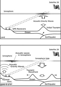
Tsunamigenic ionospheric hole
Authors: Yoshihiro Kakinami, Masashi Kamogawa et al
Link: Click here
Abstract
Traveling ionospheric disturbances generated by an epicentral
ground/sea surface motion, ionospheric disturbances associated
with Rayleigh-waves as well as post-seismic 4-minute monoperiodic
atmospheric resonances and other-period atmospheric oscillations
have been observed in large earthquakes. In addition, a giant
tsunami after the subduction earthquake produces an ionospheric
hole which is widely a sudden depletion of ionospheric total
electron content (TEC) in the hundred kilometer scale and lasts
for a few tens of minutes over the tsunami source area. The
tsunamigenic ionospheric hole detected by the TEC measurement
with Global Position System (GPS) was found in the 2011 M9.0
off the Pacific coast of Tohoku, the 2010 M8.8 Chile, and the
2004 M9.1 Sumatra earthquakes. This occurs because plasma is
descending at the lower thermosphere where the recombination
of ions and electrons is high through the meter-scale downwelling
of sea surface at the tsunami source area, and is highly depleted
due to the chemical processes.
|
|
|
Mayo de 2012
A Rogue Earthquake Off Sumatra
Authors: Jeffrey J. McGuire1 and Gregory C. Beroza
Link: Click here
Abstract
The magnitude (Mw) 8.6 earthquake of 11 April 2012 off the coast
of Sumatra is one for the record books. It is far and away the
largest strike-slip earthquake in the instrumental record. The
Mw 8.2 aftershock that occurred just over 2 hours later is
|
also
among the largest such earthquakes. Furthermore, the 11 April
mainshock may be the largest intraplate earthquake ever recorded,
although the location is consistent with the notion of a wide,
diffuse plate boundary that bisects the Indo-Australian Plate
near the Ninetyeast Ridge. The earthquakes are the latest in a
series of large (Mw 8) intraplate strike-slip earthquakes in oceanic
lithosphere. What do these earthquakes reveal about earthquake
physics, and how might they change earthquake hazard assessment?
|
|
Mayo de 2012
Seven years of postseismic deformation following the 2003
Mw = 6.8 Zemmouri earthquake (Algeria) from InSAR time series
Authors: Esra Cetin, Mustapha Meghraoui et al
Link: Click here
Abstract
We study the postseismic surface deformation of the Mw 6.8,
2003 Zemmouri earthquake (northern Algeria) using the Multi-Temporal
Small Baseline InSAR technique. InSAR time series obtained from
31 Envisat ASAR images from 2003 to 2010 reveal sub-cm coastline
ground movements between Cap Matifou and Dellys. Two regions
display subsidence at a maximum rate of 2 mm/yr in Cap Djenet
and 3.5 mm/yr in Boumerdes. These regions correlate well with
areas of
|
maximum
coseismic uplifts, and their association with two rupture segments.
Inverse modeling suggest that subsidence in the areas of high
coseismic uplift can be explained by afterslip on shallow sections
(<5 km) of the fault above the areas of coseismic slip, in
agreement with previous GPS observations. The earthquake impact
on soft sediments and the ground water table southwest of the
earthquake area, characterizes ground deformation of non-tectonic
origin. The cumulative postseismic moment due to 7 years afterslip
is equivalent to an Mw 6.3 earthquake. Therefore, the postseismic
deformation and stress buildup has significant implications on
the earthquake cycle models and recurrence intervals of large
earthquakes in the Algiers area. |
|
Mayo de 2012
Dynamic rupture of the 2011 Mw 9.0 Tohoku-Oki earthquake:
Roles of a possible subducting seamount
Author: Benchun Duan
Link: Click here
Abstract
Using a hybrid MPI/OpenMP parallel finite element method for
spontaneous rupture and seismic wave propagation simulations,
we investigate features in rupture propagation, slip distribution,
seismic radiation, and seafloor deformation of the 2011 Mw 9.0
Tohoku-Oki earthquake to gain physical insights into the event.
With simplified shallow dipping (10°) planar fault geometry,
1D velocity structure, and a slip-weakening friction law, we
primarily investigate initial stress and strength conditions
that can produce rupture and seismic radiation characteristics
of the event revealed by kinematic inversions, and seafloor
|
displacements
observed near the epicenter. By a large suite of numerical experiments
aided by parallel computing on modern supercomputers, we find
that a seamount of a dimension of ~ 70 km by 23 km just updip
of the hypocenter on the subducting plane, parameterized by higher
static friction, lower pore fluid pressure, and higher initial
stress than surrounding regions, may play a dominant role in the
2011 event. Its high strength stalls updip rupture for tens of
seconds, and its high stress drop generates large slip. Its failure
drives the rupture to propagate into the shallow portion that
is likely velocity-strengthening, resulting in significant slip
near the trench within a limited area. However, the preferred
model suggests that the largest slip in the event occurs near
the hypocenter. High-strength patches along the downdip portion
of the subducting plane are most effective among several possible
factors in generating high-frequency seismic radiations, suggesting
the initial strength distribution there is very heterogeneous.
|
|
Mayo de 2012
The 2007 M7.7 Tocopilla northern Chile earthquake sequence:
Implications for along-strike and downdip rupture segmentation
and megathrust frictional behavior
Authors: B. Schurr, G. Asch et al
Link: Click here
Abstract
In 2007 a M7.7 earthquake occurred near the town of Tocopilla
within the northern Chile seismic gap. Main shock slip, derived
from coseismic surface deformation, was confined to the depth
range between 30 and 55 km. We relocated ?1100 events during
six months before and one week after the main shock. Aftershock
seismicity is first congruent to the main shock slip and then
it spreads offshore west and northwest of Mejillones Peninsula
(MP). Waveform modeling for 38 aftershocks reveals source mechanisms
that are in the majority similar to the main shock. However,
a few events appear to occur in the upper plate, some with extensional
mechanisms.
|
Juxtaposing
the Tocopilla aftershocks with those following the neighboring
1995 Antofagasta earthquake produces a striking symmetry across
an EW axis in the center of MP. Events seem to skirt around MP,
probably due to a shallower Moho there. We suggest that the seismogenic
coupling zone in northern Chile changes its frictional behavior
in the downdip direction from unstable to mostly conditionally
stable. For both earthquake sequences, aftershocks agglomerate
in the conditionally stable region, whereas maximum inter-seismic
slip deficit and co-seismic slip occurs in the unstable region.
The boundary between the unstable and conditionally stable zones
parallels the coastline. We identify a similar segmentation for
other earthquakes in Chile and Peru, where the offshore segments
break in great M > 8 earthquakes, and the onshore segments
in smaller M < 8 earthquakes. Using critical taper analysis,
we demonstrate a causal relationship between varying slip behavior
on the interface and forearc wedge anatomy that can be attributed
to spatial variations in the rate-dependency of friction. |
|
Mayo de 2012
Modeling the effects of silica deposition and fault rupture
on natural geothermal systems
Authors: David E Dempsey, Julie Rowland et al
Link: Click here
Abstract
Natural geothermal convection abounds within the Taupo Volcanic
Zone (TVZ) of New Zealand's Central North Island. In many locations
the highly porous eruptive products that blanket the landscape
have been altered by the throughput of hydrothermal fluids and
the consequent deposition of silica. We detail a numerical model
that considers the evolution of a geothermal plume in the presence
of silica deposition/dissolution that control an evolving permeability
distribution. Precipitation of silica occurs according to a
gradient reaction regime, in which the dissolved silica concentration
is controlled by the temperature dependent silica solubility.
Over a period of 125kyr, continuous
|
geothermal circulation
leads to the development of a low permeability capzone, approximately
200 m thick, above the main geothermal upflow zone. The cap-zone
encourages lateral flow of rising fluids, increasing the area
across which geothermal expression is observed. It also has an
insulating effect on fluids below the cap, causing increases in
temperature, enthalpy, and the reservoir potential of the field.
A second model is constructed to consider the specific scenario
of fault rupture through the impermeable cap-zone. Coseismic increases
in permeability along the fault plane produce vigorous, renewed
flow through the center of the geothermal field, temporarily reducing
lateral flows. However, resealing of near surface permeability
is rapid, and the restoration of lateral flows and recovery of
the geothermal reservoir occurs within ~10kyr. These effects are
discussed in the context of two TVZ geothermal fields: the extinct
Ohakuri field, and Te Kopia, which is situated on a major active
normal fault. |
|
Mayo de 2012
Understanding of dynamic earthquake slip behavior using damage
as a tensor variable: Microcrack distribution, orientation,
and mode and secondary faulting
Author: Takehito Suzuki
Link: Click here
Abstract
The importance of the damage effect on dynamic earthquake slip
behavior is clarified using the damage tensor variable. Dynamic
mode II faults that are embedded in damage-inducing media are
assumed to relate to damage effects. This study confirms that
the rupture velocity for spontaneous fault tip growth in the
damage medium is reduced, being slightly smaller than rupture
velocities observed for classical elastic
|
material.
Inelastic energy loss resulting in damage is relatively small
but nonnegligible to the accumulated fracture energy. Two framework
parameters employed in this study determine microcrack orientations
and modes of microcracks and provide information on deviations
in microcrack distribution between isotropic and nonisotropic
ones. Spatial microcrack distribution patterns in isotropic and
homogeneous systems are strongly dependent on a parameter related
to the damage creation criterion. When considering secondary faulting,
two apparently different behaviors, pulverization and branch development,
are understood in a single framework, which gives a new insight
into fault zone formation. The present results show that damage
effect must be treated as a tensor variable rather than a scalar
one as employed in many previous studies. |
|
Mayo de 2012
The seismic coupling of subduction zones revisited
Authors: Christopher H. Scholz and Jaime Campos
Link: Click here
Abstract
The nature of seismic coupling for many of the world's subduction
zones has been reevaluated. Geodetic estimates of seismic coupling
obtained from GPS measurements of upper plate deformation during
the interseismic period are summarized. We compared those with
new estimates of seismic coupling obtained from seismological
data. The results show that with a few notable exceptions the
two methods agree to within about 10%. The seismological estimates
have been greatly improved over those made 20-30 years ago because
of an abundance of paleoseismological data that greatly extend
the
|
temporal record of great
subduction earthquakes and by the occurrence, in the intervening
years, of an unusual number of great and giant earthquakes that
have filled in some of the most critical holes in the seismic
record. The data also, again with a few notable exceptions, support
the frictional instability theory of seismic coupling, and in
particular, the test of that theory made by Scholz and Campos
(1995). Overall, the results support their prediction that high
coupling occurs for subduction zones subjected to high normal
forces with a switch to low coupling occurring fairly abruptly
as the normal force decreases below a critical value. There is
also considerable variation of coupling within individual subduction
zones. Earthquake asperities correlate with areas of high coupling
and hence have a semblance of permanence, but the rupture zones
and asperity distributions of great earthquakes may differ greatly
between seismic cycles because of differences in the phase of
seismic flux accumulation. |
|
Mayo de 2012
A new global database of Mars impact craters - Database creation,
properties, and parameters
Authors: Stuart J. Robbins and Brian M. Hynek
Link: Click here
Abstract
Impact craters have been used as a standard metric for a plethora
of planetary applications for many decades, including age-dating,
geologic mapping and stratigraphic relationships, as tracers
for surface processes, and as locations for sampling lower crust
and upper mantle material. Utilizing craters for these and other
investigations is significantly aided by an uniform
|
catalog
of craters across the surface of interest. Consequently, catalogs
of craters have been developed for decades for the Moon and other
planets. We present a new global catalog of Martian craters statistically
complete to diameters D ~ 1 km. It contains 384,343 craters, and
for each crater it lists detailed positional, interior morphologic,
ejecta morphologic and morphometric data, and modification state
information if it could be determined. In this paper, we detail
how the database was created, the different fields assigned, and
statistical uncertainties and checks. In our companion paper (Robbins
and Hynek, 2012), we discuss the first broad science applications
and results of this work. |
|
Mayo de 2012
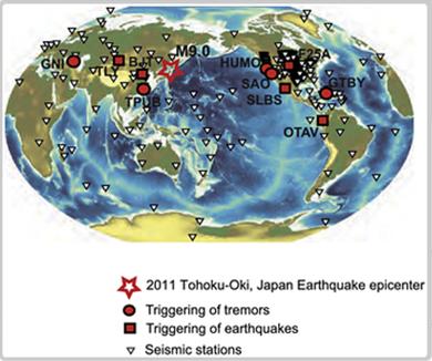
Remote triggered seismicity caused by the 2011, M9.0 Tohoku-Oki,
Japan earthquake
Authors: Hector Gonzalez-Huizar, Aaron A. Velasco et al
Link: Click here
Abstract
Seismic waves from large earthquakes have been shown to trigger
seismicity large distances from a mainshock, and this is termed
remotely or dynamically triggered seismicity. We performed a
global search for seismicity potentially triggered by the seismic
waves from the 2011, M9.0,
|
Tohoku-Oki, Japan Earthquake.
Using an event catalog, we search for earthquakes and tremors
instantaneously triggered during the passing of the seismic waves,
as well as for statistically significant changes in local and
global seismic rates after the passing of the waves. For earthquakes,
we find potential cases of instantaneous triggering in the United
States, Russia, China, Ecuador and Mexico, while for tremors we
find evidence for triggering in Taiwan, Armenia, Cuba and the
United States. In addition, we observed a potential case of delayed
triggering of larger magnitude earthquakes (including a M5.2)
in Baja California, Mexico. |
|
|
|
Mayo de 2012
Understanding Earthquakes
Author: Paul Segall
Link: Click here
Abstract
Progress in understanding the mechanics of earthquakes has come
from improvements in data collection, laboratory experiments,
and theory, allowing numerical simulations that are ever more
"Earthlike" in character. On page 707 of this issue
[Science Mag], Barbot et al. compare
|
sophisticated
dynamical simulations to a sequence of well-recorded moment magnitude
(Mw) 6.0 earthquakes along the Parkfield segment of the San Andreas
Fault. Parkfield was the site of the only official earthquake
forecast in the United States, with an intensive effort undertaken
to obtain high-resolution data near a moderate-sized shock. Although
the earthquake failed to occur within the expected time window,
it did provide a wealth of data that can be compared to the predictions
of dynamical models. |
|
Mayo de 2012
Probabilidades de ocurrencia creíbles para eventos
geofísicos extremos: Terremotos, erupciones volcánicas
y tormentas magnéticas
Autor: Jeffrey J. Love
Link: Click aquí
Abstract
El análisis estadístico de eventos geofísicos
extremos e inusuales observados en los registros históricos
se obtiene contando el número de eventos k que
superan los umbrales elegidos durante el intervalo de observación
tau. En virtud de las transformaciones que estabilizan
los datos y parámetros del modelo, las variaciones de
la tasa Poissoniana de ocurrencia más probable de eventos,
k / tau, se aplica para la inferencia frecuentista y
también, por inferencia bayesiana, con un modelo de Jeffreys
antes de que asegura la invariancia posterior bajo los cambios
de las variables. Los intervalos de confianza frecuentista y
bayesiano (Jeffreys) son aproximadamente iguales y fácil
de calcular: (1 / tau) (k - z / 2) 2, (k + z / 2) 2,
donde z es un parámetro que especifica el ancho, z
= 1 (z = 2) correspondiente a 1 sigma, 68,3% (2
sigma, 95,4%). Si sólo unos pocos eventos se han
observado, como suele ser el caso de eventos extremos, las "barras
de error" deben ser consideradas relativamente amplias.
A partir de los registros históricos conseguimos estimar
las tasas de ocurrencia más probables a largo plazo,
las probabilidades de ocurrencia a 10 años y los intervalos
de confianza y credibilidad frecuentista y bayesiano para grandes
terremotos, erupciones volcánicas explosivas y tormentas
magnéticas.
|
Mayo
de 2012
Credible occurrence probabilities for extreme geophysical
events: Earthquakes, volcanic eruptions, magnetic storms
Author: Jeffrey J. Love
Link: Click here
Abstract
Statistical analysis is made of rare, extreme geophysical events
recorded in historical data – counting the number of events
k with sizes that exceed chosen thresholds during specific
durations of time tau. Under transformations that stabilize
data and model-parameter variances, the most likely Poisson-event
occurrence rate, k/tau, applies for frequentist inference
and, also, for Bayesian inference with a Jeffreys prior that
ensures posterior invariance under changes of variables. Frequentist
confidence intervals and Bayesian (Jeffreys) credibility intervals
are approximately the same and easy to calculate: ( 1 / tau
) ( k - z / 2 ) 2 , ( k + z / 2 ) 2 , where z is a parameter
that specifies the width, z = 1 (z = 2) corresponding
to 1 sigma, 68.3% (2 sigma, 95.4%). If only a
few events have been observed, as is usually the case for extreme
events, then these “error-bar” intervals might be
considered to be relatively wide. From historical records, we
estimate most likely long-term occurrence rates, 10-yr occurrence
probabilities, and intervals of frequentist confidence and Bayesian
credibility for large earthquakes, explosive volcanic eruptions,
and magnetic storms.
|
|
Mayo de 2012
Under the Hood of the Earthquake Machine: Toward Predictive
Modeling of the Seismic Cycle
Authors: Sylvain Barbot1, Nadia Lapusta et al
Link: Click here
Abstract
development of physical models of the seismic cycle with potentially
predictive power. To explore that possibility, we developed
an integrative and fully dynamic model of the Parkfield segment
of
|
the San Andreas Fault.
The model succeeds in reproducing a realistic earthquake sequence
of irregular moment magnitude (Mw) 6.0 main shocks-including events
similar to the ones in 1966 and 2004-and provides an excellent
match for the detailed interseismic, coseismic, and postseismic
observations collected along this fault during the most recent
earthquake cycle. Such calibrated physical models provide new
ways to assess seismic hazards and forecast seismicity response
to perturbations of natural or anthropogenic origins. |
|
Mayo de 2012
Monitoring seismic velocity change caused by the 2011 Tohoku-oki
earthquake using ambient noise records
Authors: Shohei Minato, Takeshi Tsuji et al
Link: Click here
Abstract
We estimated the changes in seismic velocity in the southern
Tohoku district of Japan during the six-month period centered
on the 11 March 2011 Tohoku-oki earthquake, using scattered
waves retrieved by autocorrelation of ambient seismic noise.
The estimated velocity decrease after the
|
earthquake,
and after two large aftershocks in the study area, was as great
as 1.5% in the area nearest to the mainshock. The velocity changes
displayed gradual healing. The spatial distribution of the velocity
change showed a correlation with both the changes in static strain,
derived from GPS records, and the peak particle velocity experienced
during the three earthquakes, derived from strong-motion records.
Therefore, our results show that velocity changes possibly contain
information from deep in the crust bearing on coseismic stress
release, in addition to shallower effects due to strong ground
motion. |
|
Mayo de 2012
Unusual shallow normal-faulting earthquake sequence in compressional
northeast Japan activated after the 2011 off the Pacific coast
of Tohoku earthquake
Authors: Kazutoshi Imanishi, Ryosuke Ando et al
Link: Click here
Abstract
unusual shallow normal-faulting earthquake sequence occurred
near the Pacific coast at the Ibaraki-Fukushima prefectural
border. We have investigated why normal-faulting earthquakes
were activated in northeast (NE) Japan, which is otherwise characterized
by E-W compression. We computed the stress changes associated
with the mainshock on the basis of a finite fault slip model,
which showed that the amount of additional E-W
|
tensional
stresses in the study area was up to 1 MPa, which might be too
small to generate normal-faulting earthquakes in the pre-shock
compressional stress regime. We thus determined focal mechanisms
of microearthquakes that occurred in the area before the mainshock,
which indicated that the pre-shock stress field in the area showed
a normal-faulting stress regime in contrast to the overall reverse-faulting
regime in NE Japan. We concluded that the 2011 Tohoku earthquake
triggered the normal-faulting earthquake sequence in a limited
area in combination with a locally formed pre-shock normal-faulting
stress regime. We also explored possible mechanisms for localization
of a normal-faulting stress field at the Ibaraki-Fukushima prefectural
border. |
|
Mayo de 2012
Spherical-Earth finite element model of short-term postseismic
deformation following the 2004 Sumatra earthquake
Authors: Yan Hu, Kelin Wang et al
Link: Click here
Abstract
Decadal-scale postseismic deformation of subduction earthquakes
has been widely modeled using a Maxwell viscoelastic Earth with
a mantle-wedge viscosity of about 1019 Pa s. Short-term postseismic
deformation within a few years after the earthquake remains
a more challenging problem because of the predominance of afterslip
of the megathrust and the potentially more complex mantle rheology.
Questions include the necessity of invoking the transient rheology
and the relative importance of contributions from afterslip
and viscoelastic relaxation. In this work, we address these
questions by developing a
|
spherical-Earth
viscoelastic finite element model for the short-term postseismic
deformation following the magnitude 9.2 Sumatra earthquake of
2004. The model consists of elastic overriding and subducting
plates and a viscoelastic mantle of bi-viscous Burgers rheology,
with the continental mantle (mantle wedge) being less viscous
than the oceanic mantle by a factor of ten. Primary observational
constraints for the short-term postseismic deformation include
?1 year net displacements of nine near-field GPS sites and ~ 3
year time series from three far-field sites several hundred kilometers
from the 2004 rupture zone. Model results indicate that the afterslip
of the fault must be at work within the first few years after
the earthquake. The observed deformation is best explained with
a model that includes both the afterslip and transient rheology.
In the preferred model, the transient and steady state viscosities
of the mantle wedge are 5 × 10¹⁷ Pa s and 1019 Pa s, respectively.
|
|
Mayo de 2012
Spatial variations in earthquake source characteristics within
the 2011 Mw = 9.0 Tohoku, Japan rupture zone
Authors: Susan L. Bilek, Heather R. DeShon et al
Link: Click here
Abstract
The great Mw = 9.0 2011 Tohoku earthquake appears to have complex
rupture characteristics, with slower rupture velocity during
the early portion of the rupture and spatial variations in the
radiation frequency content. These spatial and temporal variations
suggest that the subduction
|
zone
fault has spatially varying friction conditions that led to differences
in the 2011 rupture characteristics, conditions that might also
affect other earthquakes within the rupture zone. We find spatial
variations for source parameters of 90 relocated earthquakes between
1992 and 2011 along northern Japan, with longer durations observed
in shallow near trench events relative to shorter duration deeper
events. A majority of these events do not lie within the high
slip zone of 2011, however, and occur instead in the region of
the 1896 tsunami earthquake to the north. We also find correlation
between the longest duration event locations and low seismic velocities
based on recent tomography models. |
|
Mayo de 2012
Influence of pore-pressure on the event-size distribution
of induced earthquakes
Authors: C. E. Bachmann, S. Wiemer et al
Link: Click here
Abstract
During an Enhanced Geothermal System (EGS) experiment, fluid
is injected at high pressure into crystalline rock, to enhance
its permeability and thus create a reservoir from which geothermal
heat can be extracted. The fracturing of the basement caused
by these high pore-pressures is associated with microseismicity.
However, the relationship between the magnitudes of these
|
induced
seismic events and the applied fluid injection rates, and thus
pore-pressure, is unknown. Here we show how pore-pressure can
be linked to the seismic frequency-magnitude distribution, described
by its slope, the b-value. We evaluate the dataset of an EGS in
Basel, Switzerland and compare the observed event-size distribution
with the outcome of a minimalistic model of pore-pressure evolution
that relates event-sizes to the differential stress ?D. We observe
that the decrease of b-values with increasing distance of the
injection point is likely caused by a decrease in pore-pressure.
This leads to an increase of the probability of a large magnitude
event with distance and time. |
|
Mayo de 2012
Improving tsunami warning using commercial ships
Authors: James H. Foster, Benjamin A. Brooks et al
Link: Click here
Abstract
Accurate and rapid detection and assessment of tsunamis is critical
for effective mitigation. We show here that a modest ?10 cm
tsunami from the M8.8 27 Feb 2010 Maule, Chile earthquake was
detected by kinematic Global Positions System (GPS) solutions
from a ship underway in the open ocean - the first time shipboard
tsunami
|
detection has been achieved. Our results illustrate
how the commercial shipping fleet represents a vast infrastructure
of potential open ocean GPS platforms on shipping lanes that
provide extremely good spatial coverage around most tsunamigenic
source regions. Given the affordability of geodetic GPS systems,
and ever-improving satellite communications, it would be possible
to equip a significant portion of the shipping fleet with real-time-streamed
GPS systems and create a cost-effective tsunami monitoring network
with denser and more distributed coverage. We project that such
a system would have detected the 2004 Indian Ocean tsunami in
less than an hour.
|
|
Abril de 2012
Frictional behavior of oceanic transform faults and its influence
on earthquake characteristics
Authors: Yajing Liu, Jeffrey J. McGuire et al
Link: Click here
Abstract
We use a three-dimensional strike-slip fault model in the framework
of rate and state-dependent friction to investigate earthquake
behavior and scaling relations on oceanic transform faults (OTFs).
Gabbro friction data under hydrothermal conditions are mapped
onto OTFs using temperatures from (1) a half-space cooling model,
and (2) a thermal model that incorporates a visco-plastic rheology,
non-Newtonian viscous flow and the effects of shear heating
and hydrothermal circulation. Without introducing small-scale
frictional heterogeneities on the fault, our model predicts
that an OTF segment can transition between seismic and
|
aseismic
slip over many earthquake cycles, consistent with the multimode
hypothesis for OTF ruptures. The average seismic coupling coefficient
xi is strongly dependent on the ratio of seismogenic zone width
W to earthquake nucleation size h*;xi increases by four orders
of magnitude as W/h* increases from ~1 to 2. Specifically, the
average ? = 0.15 ± 0.05 derived from global OTF earthquake
catalogs can be reached at W/h* ˜ 1.2-1.7. Further, in all
simulations the area of the largest earthquake rupture is less
than the total seismogenic area and we predict a deficiency of
large earthquakes on long transforms, which is also consistent
with observations. To match these observations over this narrow
range of W/h* requires an increase in the characteristic slip
distance dc as the seismogenic zone becomes wider and normal stress
is higher on long transforms. Earthquake magnitude and distribution
on the Gofar and Romanche transforms are better predicted by simulations
using the visco-plastic model than the half-space cooling model.
|
|
Abril de 2012
Aftershock seismicity of the 2010 Maule Mw=8.8, Chile, earthquake:
Correlation between co-seismic slip models and aftershock distribution?
Authors: A. Rietbrock, I. Ryder et al
Link: Click here
Abstract
The 27 February 2010 Maule, Chile (Mw=8.8) earthquake is one
of the best instrumentally observed subduction zone megathrust
events. Here we present locations, magnitudes and cumulative
equivalent moment of the first ~2 months of aftershocks, recorded
on a temporary network deployed within 2 weeks of the occurrence
of the mainshock. Using automatically-determined onset times
and a back projection approach for event association, we are
able to detect over 30,000 events in the time period analyzed.
To further increase the location
|
accuracy, we systematically
searched for potential S-wave arrivals and events were located
in a regional 2D velocity model. Additionally, we calculated regional
moment tensors to gain insight into the deformation history of
the aftershock sequence. We find that the aftershock seismicity
is concentrated between 40 and 140 km distance from the trench
over a depth range of 10 to 35 km. Focal mechanisms indicate a
predominance of thrust faulting, with occasional normal faulting
events. Increased activity is seen in the outer-rise region of
the Nazca plate, predominantly in the northern part of the rupture
area. Further down-dip, a second band of clustered seismicity,
showing mainly thrust motion, is located at depths of 40-45 km.
By comparing recent published mainshock source inversions with
our aftershock distribution, we discriminate slip models based
on the assumption that aftershocks occur in areas of rapid transition
between high and low slip, surrounding high-slip regions of the
mainshock. |
|
Abril de 2012
Tidal triggering of earthquakes prior to the 2011 Tohoku-Oki
earthquake (Mw 9.1)
Author: Sachiko Tanaka
Link: Click here
Abstract
I observe highly significant tidal triggering of earthquakes
prior to the 2011 Mw 9.1 Tohoku-Oki earthquake. Strong statistical
correlations between tidally-induced stresses and earthquake
|
occurrence
times are identified in the northern part of the Tohoku-Oki source
region, where the mainshock rupture initiated, in the several
to ten years before the Tohoku-Oki earthquake. The tidal phase
distribution of earthquakes in this period exhibits a peak where
the shear stress is at its maximum to promote failure. On the
other hand, no significant tidal correlation is found after the
Tohoku-Oki mainshock. These observations suggest that tidal triggering
occurs over a decade-long period preceding the Tohoku-Oki earthquake,
and the initial rupture site of this event is already critically
stressed in this precursory stage. |
|
Abril de 2012
Spatial migration of earthquakes within seismic clusters
in Southern California: Evidence for fluid diffusion
Authors: X. Chen, P. M. Shearer et al
Link: Click here
Abstract
Seismicity within many earthquake swarms is observed to migrate
slowly with time, which may reflect event triggering due to
slow fault slip or fluid flow. We search for this behavior in
Southern California by applying a weighted least squares method
to quantify event migration within 69 previously observed seismicity
bursts. We obtain best-fitting migration directions and velocities,
and compute a statistical migration significance sm for each
burst using a bootstrap resampling method. We define 37 bursts
with sm = 0.8 as the migration group, and 32 bursts with sm
< 0.8 as the non-migration group. To explore differences
between the two groups, for each burst we
|
compute effective stress
drop (delta sigma quasi, the ratio between total moment and radius),
the skew of the moment release time series (µ), the timing
of the largest event (tmax), and the distance separation between
the first half and second half of the sequence (ds). As expected,
the migration group features larger ds and lower ?squasi, consistent
with higher migration significance. It also features lower µ
and higher tmax, similar to observations from swarms in the Salton
Trough, while the non-migration group is more similar to main
shock-aftershock sequences. To explore possible fluid involvement,
we model the migration behavior with the fluid diffusion equation,
and identify 18 bursts with diffusion coefficients ranging from
0.01 to 0.8 m2/s, with the majority below 0.16 m2/s. The obtained
diffusion coefficients and migration behavior are similar to the
Reservoir-induced seismicity beneath the Açu reservoir
in Brazil. The majority of normal faulting events are associated
with these 18 bursts, while the non-migration group has the most
reverse faulting events, indicating a possible link between sequence
type and focal mechanism. |
|
Abril de 2012
Tidal triggering of earthquakes prior to the 2011 Tohoku-Oki
earthquake (Mw 9.1)
Author: Sachiko Tanaka
Link: Click here
Abstract
I observe highly significant tidal triggering of earthquakes
prior to the 2011 Mw 9.1 Tohoku-Oki earthquake. Strong statistical
correlations between tidally-induced stresses and earthquake
|
occurrence
times are identified in the northern part of the Tohoku-Oki source
region, where the mainshock rupture initiated, in the several
to ten years before the Tohoku-Oki earthquake. The tidal phase
distribution of earthquakes in this period exhibits a peak where
the shear stress is at its maximum to promote failure. On the
other hand, no significant tidal correlation is found after the
Tohoku-Oki mainshock. These observations suggest that tidal triggering
occurs over a decade-long period preceding the Tohoku-Oki earthquake,
and the initial rupture site of this event is already critically
stressed in this precursory stage. |
|
Abril de 2012
Geoelectric observations of the degradation of nearshore
submarine permafrost at Barrow (Alaskan Beaufort Sea)
Authors:Pier Paul Overduin, Sebastian Westermann et al
Link: Click here
Abstract
Submarine permafrost degradation rates may be determined by
a number of interacting processes, including rates of sea level
rise and coastal erosion, sea bottom temperature and salinity
regimes, geothermal heat flux and heat and mass diffusion within
the sediment column. Observations of ice-bearing permafrost
in shelf sediments are necessary in order to determine its spatial
distribution and to quantify its degradation rate. We tested
the use of direct current electrical
|
resistivity to ice-bearing
permafrost in Elson Lagoon northeast of Barrow, Alaska (Beaufort
Sea). A sharp increase in electrical resistivity was observed
in profiles collected perpendicular to and along the coastline
and is interpreted to be the boundary between ice-free sediment
and underlying ice-bearing submarine permafrost. The depth to
the interpreted ice-bearing permafrost increases from <2 m
below sea level to over 12 m below sea level with increasing distance
from the coastline. The dependence of the saline sediment electrical
resistivity on temperature and freezing was measured in the laboratory
to provide validation for the field measurements. Electrical resistivity
was shown to be effective for detection of shallow ice-bearing
permafrost in the coastal zone. Historical coastal retreat rates
were combined with the inclination of the top of the ice-bearing
permafrost to calculate mean vertical permafrost degradation rates
of 1 to 4 cm yr-1. |
|
Marzo de 2012
Relation between subduction megathrust earthquakes, trench
sediment thickness and upper plate strain
Authors: Arnauld Heuret, Clinton P. Conrad et al
Link: Click here
Abstract
Giant earthquake (moment magnitude Mw ³ 8.5) forecasts
for subduction zones have been empirically related to both tectonic
stresses and geometrical irregularities along the subduction
interface. Both of these controls have been suggested as able
to tune the ability of rupture to propagate laterally and, in
turn, exert an important control on giant earthquake generation.
Here we test these hypotheses, and their combined influence,
by compiling a dataset of trench fill thickness (a proxy for
smoothing of subducting plate relief by sediment input into
the subduction
|
channel)
and upper plate strain (a proxy for the tectonic stresses applied
to the subduction interface) for 44 segments of the global subduction
network. We statistically compare relationships between upper
plate strain, trench sediment thickness and maximal earthquake
magnitude. We find that the combination of both large trench fill
({greater than or equal to}1 km) and neutral upper plate strain
explains spatial patterns of giant earthquake occurrence to a
statistically significant degree. In fact, the concert of these
two factors is more highly correlated with giant earthquake occurrence
than either factor on its own. Less frequent giant earthquakes
of lower magnitude are also possible at subduction zones with
thinner trench fill and compressive upper plate strain. Extensional
upper plate strain and trench fill < 0.5 km appear to be unfavorable
conditions, as giant earthquakes have not been observed in these
geodynamical environments during the last 111 years. |
|
Marzo de 2012
Excess hafnium-176 in meteorites and the early Earth zircon
record
Authors: Martin Bizzarro, James Connelly et al
Link: Click here
Abstract
Lars Borg
The long-lived 176Lu-to-176Hf decay system is a powerful tool
to understand ancient chemical fractionation events associated
with planetary differentiation. Detrital Hadean zircons (>3.8
Gyr) from the Jack Hills metasedimentary belt of Western Australia
record extremely enriched Hf-isotope signals suggesting early
extraction of a continental crust (>4.5 Gyr) but fail to
identify a prevalent complementary depleted mantle reservoir,
suggesting that crust formation processes in the early Earth
were fundamentally distinct from today. However, this conclusion
assumes that the Hf-isotope composition of bulk chondrite meteorites
can be used to estimate the
|
composition of Earth
prior to its differentiation into major silicate reservoirs, namely
the bulk silicate Earth (BSE). We report a 176Lu-176Hf internal
mineral isochron age of 4869{plus minus}34 Myr for the pristine
SAH99555 angrite meteorite. This age is ~300 Myr older than the
age of the Solar System, confirming the existence of an energetic
process yielding excess 176Hf in affected early-formed Solar System
objects through the production of the 176Lu isomer (t1/2~3.9 hours).
Thus, chondrite meteorites contain excess 176Hf and their present-day
composition cannot be used to infer the Lu- Hf parameters of BSE.
Using a revised BSE estimate based on the SAH99555 isochron, we
show that Earth's oldest zircons preserve a record of coexisting
enriched and depleted hafnium reservoirs as early as ~4.3 Gyr
in Earth's history, with little evidence for the existence of
continental crust prior to ~4.4 Gyr. This new view suggests continuous
juvenile crustal growth and recycling through-out the Hadean and
Archean eras, perhaps analogous to modern plate tectonics. |
|
Marzo de 2012
Transdimensional inverse thermal history modeling for quantitative
thermochronology
Author: Kerry Gallagher
Link: Click here
Abstract
A new approach for inverse thermal history modeling is presented.
The method uses Bayesian transdimensional Markov Chain Monte
Carlo and allows us to specify a wide range of possible thermal
history models to be considered as general prior information
on time, temperature (and temperature offset for multiple samples
in a vertical profile). We can also incorporate more focused
geological constraints in terms of more specific priors. The
Bayesian approach naturally
|
prefers
simpler thermal history models (which provide an adequate fit
to the observations), and so reduces the problems associated with
over interpretation of inferred thermal histories. The output
of the method is a collection or ensemble of thermal histories,
which quantifies the range of accepted models in terms a (posterior)
probability distribution. Individual models, such as the best
data fitting (maximum likelihood) model or the expected model
(effectively the weighted mean from the posterior distribution)
can be examined. Different data types (e.g., fission track, U-Th/He,
40Ar/39Ar) can be combined, requiring just a data-specific predictive
forward model and data fit (likelihood) function. To demonstrate
the main features and implementation of the approach, examples
are presented using both synthetic and real data. |
|
Marzo de 2012
Are megaquakes clustered?
Authors: Eric G. Daub, Eli Ben-Naim et al
Link: Click here
Abstract
We study statistical properties of the number of large earthquakes
over the past century. We analyze the cumulative distribution
of the number of earthquakes with magnitude larger than threshold
M in time interval T, and quantify the statistical significance
of these results by
|
simulating
a large number of synthetic random catalogs. We find that in general,
the earthquake record cannot be distinguished from a process that
is random in time. This conclusion holds whether aftershocks are
removed or not, except at magnitudes below M = 7.3. At long time
intervals (T = 2-5 years), we find that statistically significant
clustering is present in the catalog for lower magnitude thresholds
(M = 7-7.2). However, this clustering is due to a large number
of earthquakes on record in the early part of the 20th century,
when magnitudes are less certain. |
|
|
|
Febrero de 2012
Thirty years of elevation change on Antarctic Peninsula ice
shelves from multi-mission satellite radar altimetry
Authors: Helen Amanda Fricker and Laurence Padman
Link: Click here
Abstract
We use data acquired between 1978 and 2008 by four satellite
radar altimeter missions (Seasat, ERS-1, ERS-2 and Envisat)
to determine multi-decadal elevation change rates (dhi/dt) for
six major Antarctic Peninsula (AP) ice shelves. In areas covered
by the Seasat orbit (to 72.16oS), regionally-averaged 30-year
trends were negative (surface lowering), with rates between
-0.03 and -0.16 m a-1. Surface lowering preceded the start of
near-continuous radar altimeter operations that began with ERS-1
in 1992. The average rate of
|
lowering
for the first 14 years of the period was typically smaller than
the 30-year average; the exception was the southern Wilkins Ice
Shelf, which experienced negligible lowering between 2000 and
2008, when a series of large calving events began. Analyses of
the continuous ERS/Envisat time series (to 81.5o) for 1992-2008
reveal a period of strong negative dhi/dt on most ice shelves
between 1992 and 1995. Based on prior studies of regional atmospheric
and oceanic conditions, we hypothesize that the observed elevation
changes on Larsen C Ice Shelf are driven primarily by firn compaction
while the western AP ice shelves are responding to changes in
both surface mass balance and basal melt rates. Our time series
also show that large changes in dhi/dt can occur on interannual
time scales, reinforcing the importance of long time series altimetry
to separate long-term trends associated with climate change from
interannual to interdecadal natural variability. |
|
Febrero de 2012
Fixed recurrence and slip models better predict earthquake
behavior than the time- and slip-predictable models: 1. Repeating
earthquakes
Authors: N. D'Agostino, D. Cheloni et al
Link: Click here
Abstract
The behavior of individual events in repeating earthquake sequences
in California, Taiwan and Japan is better predicted by a model
with fixed inter-event time or fixed slip than it is by the
time- and slip-predictable models for earthquake occurrence.
Given that repeating earthquakes are highly regular in both
inter-event time and seismic moment, the time- and slip-predictable
models seem ideally suited to explain their behavior. Taken
together with evidence from the companion manuscript that shows
similar results for laboratory experiments we conclude that
the short-term predictions of the time- and slip-predictable
models should be rejected in favor of earthquake models that
assume either fixed slip or fixed recurrence interval. This
implies that the elastic rebound model underlying the time-
and slip-predictable models offers no additional value in describing
earthquake behavior in an event-to-event sense, but its value
in a long-term sense cannot be determined. These models likely
fail because they rely on assumptions that oversimplify the
earthquake cycle. We note that the time and slip of these events
is predicted quite well by fixed slip and fixed recurrence models,
so in some sense they are time- and slip-predictable. While
fixed recurrence and slip models better predict repeating earthquake
behavior than the time- and slip-predictable models, we observe
a correlation between slip and the preceding recurrence time
for many repeating earthquake sequences in Parkfield, California.
This correlation is not found in other regions, and the sequences
with the correlative slip-predictable behavior are not distinguishable
from nearby earthquake sequences that do not exhibit this behavior.
|
Febrero de 2012
Fixed recurrence and slip models better predict earthquake
behavior than the time- and slip-predictable models: 2. Laboratory
earthquakes
Authors: Justin L. Rubinstein, William L. Ellsworth et al
Link: Click here
Abstract
The behavior of individual stick-slip events observed in three
different laboratory experimental configurations is better explained
by a "memoryless" earthquake model with fixed inter-event
time or fixed slip than it is by the time- and slip-predictable
models for earthquake occurrence. We make similar findings in
the companion manuscript for the behavior of natural repeating
earthquakes. Taken together, these results allow us to conclude
that the predictions of a characteristic earthquake model that
assumes either fixed slip or fixed recurrence interval should
be preferred to the predictions of the time- and slip-predictable
models for all earthquakes. Given that the fixed slip and recurrence
models are the preferred models for all of the experiments we
examine, we infer that in an event-to-event sense the elastic
rebound model underlying the time- and slip-predictable models
does not explain earthquake behavior. This does not indicate
that the elastic rebound model should be rejected in a long-term-sense,
but it should be rejected for short-term predictions. The time-
and slip-predictable models likely offer worse predictions of
earthquake behavior because they rely on assumptions that are
too simple to explain the behavior of earthquakes. Specifically,
the time-predictable model assumes a constant failure threshold
and the slip-predictable model assumes that there is a constant
minimum stress. There is experimental and field evidence that
these assumptions are not valid for all earthquakes.
|
|
Febrero de 2012
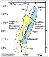
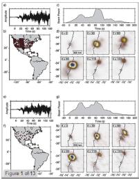
Imaging short-period seismic radiation from the 27 February
2010 Chile (MW 8.8) earthquake by back-projection of P, PP,
and PKIKP waves
Authors: Keith D. Koper, Alexander R. Hutko et al
Link: Click here
Abstract
Teleseismic short-period (0.5-5 s) P waves from the 27 February
2010 Chile earthquake (Mw 8.8) are back projected to the source
region to image locations of coherent short-period seismic wave
radiation. Several receiver array configurations are analyzed
using different P wave arrivals, including networks of stations
in North America (P), Japan (PKIKP), and Europe (PP), as well
as a global configuration of stations with a broad azimuthal
distribution and longer-period P waves (5-20 s). Coherent bursts
of short-period radiation from the source are concentrated below
the Chilean coastline, along the downdip portion of the megathrust.
The short-period source region expands bilaterally, with significant
irregularity in the radiation. Comparison with finite fault
slip models inverted from longer-period seismic waves indicates
that the regions of large slip on the megathrust are located
updip of the regions of short-period radiation, a manifestation
of frequency-dependent seismic radiation, similar to observations
for the great 2011 Tohoku earthquake (Mw 9.0). Back projection
of synthetic P waves generated from the finite fault models
demonstrates that if the short-period energy had radiated with
the same space-time distribution as the long-period energy,
back-projection analysis would image it in the correct location,
updip. We conclude that back-projection imaging of short-period
signals provides a distinct view of the seismic source that
is missed by studies based only on long-period seismic waves,
geodetic data, and/or tsunami observations.
|
|
|
Febrero de 2012
Spectral induced polarization of shaly sands: Influence of
the electrical double layer
Author: A. Revil
Link: Click here
Abstract
I developed a new model named POLARIS describing the complex
conductivity of (pyrite-free) shaly poorly sorted sands. This
model is based on the solution given by the effective medium
theory for grains coated by an electrical double layer and immersed
in a background electrolyte. The electrical double layer comprises
the Stern layer and the diffuse layer. Both layers play very
distinct roles in the in-phase and quadrature conductivities.
The polarization of the shaly sands is mainly controlled by
the polarization of the Stern layer (except at very high salinities)
with a very small mobility of the counterions contained in this
layer. The in-phase component of the conductivity
|
is
controlled by the conductivity of the pore water with a contribution
associated with the diffuse layer (the contribution of the Stern
layer seems negligible). The fraction of counterions in the Stern
layer is computed from a simple sorption isotherm and is used
to infer the quadrature conductivity. The quadrature conductivity
is assumed to be frequency independent, which is a reasonable
approximation in clayey sands and sandstones, in agreement with
observations. The polarization model is also based on the assumption
that the Stern layer is discontinuous between grains, an assumption
that is consistent with recent models of ionic transport in clayey
sands. POLARIS explains the dependence of the quadrature conductivity
on the salinity, cation exchange capacity, specific surface area
(or specific surface per unit pore volume), and temperature. It
can be used to predict the saturation and the permeability (inside
1 order of magnitude). |
|
Febrero de 2012
Space-time distribution of afterslip following the 2009 L'Aquila
earthquake
Authors: N. D'Agostino, D. Cheloni et al
Link: Click here
Abstract
The inversion of multitemporal DInSAR and GPS measurements unravels
the coseismic and postseismic (afterslip) slip distributions
associated with the 2009 MW 6.3 L'Aquila earthquake and provides
insights into the rheological properties and long-term behavior
of the responsible structure, the Paganica fault. Well-resolved
patches of high postseismic slip (10-20 cm) appear to surround
the main coseismic patch (maximum slip ˜1 m) through the
entire seismogenic layer above the hypocenter without any obvious
depth-dependent control. Time series of postseismic displacement
are well reproduced by an exponential function with best-fit
decay constants in the range of 20-40 days. A sudden discontinuity
in the evolution of released postseismic moment at ˜130
days after the main shock does not correlate with independent
seismological and geodetic data and is attributed to residual
noise in the InSAR time series. The data are unable to resolve
migration of afterslip
|
along
the fault probably because of the time interval (six days) between
the main shock and the first radar acquisition. Surface fractures
observed along the Paganica fault follow the steepest gradients
of postseismic line-of-sight satellite displacements and are consistent
with a sudden and delayed failure of the shallow layer in response
to upward tapering of slip. The occurrence of afterslip at various
levels through the entire seismogenic layer argues against exclusive
depth-dependent variations of frictional properties on the fault,
supporting the hypothesis of significant horizontal frictional
heterogeneities and/or geometrical complexities. We support the
hypothesis that such heterogeneities and complexities may be at
the origin of the long-term variable behavior suggested by the
paleoseismological studies. Rupture of fault patches with dimensions
similar to that activated in 2009 appears to have a ˜500
year recurrence time interval documented by paleoseismic and historical
studies. In addition to that, paleoseismological evidence of large
(>0.5 m) coseismic offsets seems to require seismic events,
recurring every 1000-2000 years, characterized by (1) multisegment
linkage, (2) surface ruptures larger than in 2009, and (3) complete
failure of the 2009 coseismic and postseismic patches. |
|
Febrero de 2012
Rupture directivity of the 2011, Mw 5.2 Lorca earthquake
(Spain)
Authors: José-Ángel López-Comino, Flor
de Lis Mancilla et al
Link: Click here
Abstract
On May 11th 2011, a rather small earthquake caused nine fatalities
in the city of Lorca, SE-Spain. We analyze seismograms from
a dense network to characterize the source of this earthquake.
We estimate an oblique reverse faulting mechanism, moment magnitude
of 5.2
|
and a shallow hypocenter
(4.6 km), at only 5.5 km epicentral distance from the city center.
Double difference relocations yield a ~5 km long, NE-SW trending
distribution of aftershocks SW of the mainshock, suggesting a
SW propagating rupture along the Alhama de Murcia fault. We use
the Mw 4.6 foreshock and an Mw 3.9 aftershock as empirical Greens
functions to estimate apparent source time functions, observing
a clear directivity effect. We model apparent durations with a
unilateral and asymmetric bilateral rupture, in both cases obtaining
rupture directivity of ~N220°E, towards Lorca. In addition
to the near epicenter and shallow depth, directivity may have
contributed to the significant impact. |
|
Febrero de 2012
Stress before and after the 2011 great Tohoku-oki earthquake
and induced earthquakes in inland areas of eastern Japan
Authors: Keisuke Yoshida, Akira Hasegawa et al
Link: Click here
Abstract
Stress fields in inland areas of eastern Japan before and after
the Tohoku-oki earthquake were estimated by inverting focal
mechanism data. Before the earthquake, s1 axis was oriented
EW in Tohoku but NW-SE in Kanto-Chubu. The stress fields changed
after the earthquake in northern Tohoku and in southeastern
Tohoku near Iwaki
|
city, where the orientations
of the principal stresses became approximately the same as the
orientations of the static stress change associated with the earthquake.
This indicates that differential stress magnitudes in these areas
before the earthquake were smaller than 1 MPa. The stress field
did not change in central Tohoku, even though the stresses loaded
after the earthquake had nearly reversed orientations, which indicates
that the differential stress magnitudes there were significantly
larger than 1 MPa. In Kanto-Chubu, stresses having nearly the
same orientations as the background stresses were loaded after
the earthquake, and the stress fields did not change as expected.
This may have caused very high induced seismicities in Kanto-Chubu.
|
|
Febrero
de 2012
A Rayleigh wave back-projection method applied to the 2011
Tohoku earthquake
Authors: Daniel Roten, Hiroe Miyake et al
Link: Click here
Abstract
We study the rupture process of the 2011 Tohoku megathrust by
analyzing 384 regional strong-motion records using a novel back-projection
method for Rayleigh waves with periods between 13 and 100 s.
The proposed approach is based on isolating the signal at the
selected period with a continuous wavelet transform, and generating
the stack using arrival times predicted from detailed fundamental
mode Rayleigh wave group velocity maps. We verify the method
by back-projecting synthetic time series representing a point
source off the coast of Tohoku, which we generate with a 3D
finite difference method and a mesh based on the Japan Integrated
Velocity
|
Structure
Model. Application of the method to K- NET/KiK-net records of
the Mw 9.1 Tohoku earthquake reveals several Rayleigh wave emitters,
which we attribute to different stages of rupture. Stage 1 is
characterized by slow rupture down-dip from the hypocenter. The
onset of stage 2 is marked by energetic Rayleigh waves emitted
from the region between the JMA hypocenter and the trench within
60 s after hypocentral time. During stage 3 the rupture propagates
bilaterally towards the north and south at rupture velocities
between 3 and 3.5 km · s?1, reaching Iwate-oki 65 s and
Ibaraki-oki 105 s after nucleation. In contrast to short-period
back-projections from teleseismic P-waves, which place radiation
sources below the Honshu coastline, Rayleigh wave emitters identified
from our long-period back-projection are located 50-100 km west
of the trench. This result supports the interpretation of frequency-dependent
seismic wave radiation as suggested in previous studies. |
|
Enero de 2012
Mineral, Virginia, earthquake illustrates seismicity of a
passive-aggressive margin
Authors: Emily Wolin, Seth Stein et al
Link: Click here
Abstract
The August 2011 M 5.8 Mineral, Virginia, earthquake that shook
much of the northeastern U.S. dramatically demonstrated that
passive continental margins sometimes have large earthquakes.
We illustrate some general aspects of such earthquakes and outline
some of the many unresolved questions about them. They occur
both offshore and onshore, reaching magnitude 7, and are thought
to reflect reactivation of favorably-oriented, generally margin-parallel,
faults created during one or more
|
Wilson cycles by the modern stress field. They pose both tsunami
and shaking hazards. However, their specific geologic setting
and causes are unclear because large magnitude events occur
infrequently, microseismicity is not well recorded, and there
is little, if any, surface expression of repeated ruptures.
Thus presently active seismic zones may be areas associated
with higher seismicity over the long term, the present loci
of activity that migrates, or aftershock zones of large prehistoric
earthquakes. The stresses causing the earthquakes may result
from platewide driving forces, glacial isostatic adjustment,
localized margin stresses, and/or dynamic topography. The resulting
uncertainties make developing cost-effective mitigation strategies
a major challenge. Progress on these issues requires integrating
seismic, geodetic, and geological techniques.
|
Enero
de 2012
Transforming Earthquake Detection?
Author: Richard M. Allen
Link: Click here
Abstract
Earthquakes are a collective experience. Citizens have long
participated in earthquake science through the reporting, collection,
and analysis of individual experiences. The value of citizen-generated
status reports was clear after the 1995 Kobe, Japan, earthquake.
Today's communications infrastructure has taken citizen engagement
to a new level: Earthquake-related Twitter messages can outrun
the shaking, Internet traffic detects earthquakes and maps the
distribution of shaking in minutes , and accelerometers in consumer
electronic devices record seismic waveforms. What are we learning
from this flood of data, and what are the limitations? How do
we harness these new capabilities for scientific discovery,
and what is the role of education?
|
Modern geophysical instruments
can record a magnitude 5 (M5) earthquake from the other side of
the world. However, to map, track, and analyze the details of
large destructive earthquake ruptures, and to elucidate how the
rupture process links to earthquake impacts, requires detailed
data from close to the event. Currently, the best traditional
geophysical networks only have stations every ~10 km and cover
limited areas. Contributions of citizens have the potential to
provide much higher resolution, especially in residential areas.
The best-developed citizen-based earthquake science project today
is the U.S. Geological Survey's (USGS) "Did You Feel It?"
(DYFI) (8-10). After an earthquake, individuals can go online
and answer questions designed to capture the data necessary to
estimate shaking intensity. The location information of each report
is converted to latitude-longitude coordinates and the data are
mapped. Online tools allow users to explore the data set that
includes their contribution. The project also has an educational
component explaining earthquake phenomena... |
Enero
de 2012
A Tantalizing View of What Set Off Japan's Killer Quake
Author: Richard A. Kerr
Link: Click here
Abstract
Japanese scientists combing through the vast jumble of seismic
signals recorded in the days before the great magnitude-9.0
earthquake that ravaged their homeland have just sorted out
more than 1000 newly recognized earthquakes. The find reveals
how the lethal offshore fault slipped slowly just before it
ripped loose. That slow slip now appears to have loaded the
fault to the breaking point, triggering the devastating quake
last March.
|
The
work-the fruit of decades of intensive monitoring around Japan-gives
seismologists a much-anticipated peek into a fundamental mystery:
"How does a big earthquake happen?" asks seismologist
Lucile Jones of the U.S. Geological Survey (USGS) in Pasadena,
California. Although it is a long-sought precursor to a big quake,
the slow slip "is not a tool for prediction," she quickly
adds, at least not by itself. It does, however, suggest that this
time, in this place, Earth held one clue that a big quake was
imminent. Researchers' next step-learning whether such a clue
is rare or commonplace-will require close looks at many more earthquakes... |
Enero
de 2012
A Long-Lived Lunar Core Dynamo
Authors: Erin K. Shea, Benjamin P. Weiss et al
Link: Click here
Abstract
Paleomagnetic measurements indicate that a core dynamo probably
existed on the Moon 4.2 billion years ago. However, the subsequent
history of the lunar core dynamo is unknown. Here we report
paleomagnetic, petrologic, and 40Ar/39Ar thermochronometry measurements
on the 3.7-billion-year-old mare basalt sample 10020. This sample
contains a high-coercivity magnetization acquired in a stable
field of at least ~12 microteslas. These data extend the known
lifetime of the lunar dynamo by 500 million years. Such a long-lived
lunar dynamo probably required a power source other than thermochemical
convection from secular cooling of the lunar interior. The inferred
strong intensity of the lunar paleofield presents a challenge
to current dynamo theory.
|
The
discovery of remanent magnetization in samples taken by the Apollo
lunar missions and by spacecraft observations of the lunar crust
has long suggested that the Moon formed a metallic core and a
dynamo-generated magnetic field. However, the association of magnetization
with the antipodes of impact basins and laboratory studies of
transient plasma-generated magnetic fields suggest that meteoroid
impacts could also be a source of lunar magnetization. Because
impact fields from the largest basin-forming events are expected
to last less than 1 day, they should only be recorded by shocked
or quickly cooled rocks. Therefore, to identify records of a core
dynamo field, it is important to study slowly cooled samples with
high magnetic recording fidelity that show no petrographic evidence
of shock. Unfortunately, few lunar rocks have all of these properties.
An exception is lunar troctolite sample 76535, which was observed
to have a stable natural remanent magnetization (NRM) formed in
a field of ~1 to 50 µT that is stable up to coercivities
>200 mT. The magnetic history of this sample, coupled... |
|
Enero de 2012
Generation and evolution of hydrothermal fluids at Yellowstone:
Insights from the Heart Lake Geyser Basin
Authors: J. B. Lowenstern, D. Bergfeld et al
Link: Click here
Abstract
We sampled fumaroles and hot springs from the Heart Lake Geyser
Basin (HLGB), measured water and gas discharge, and estimated
heat and mass flux from this geothermal area in 2009. The combined
data set reveals that diverse fluids share an origin by mixing
of deep solute-rich parent water with dilute heated meteoric
water, accompanied by subsequent boiling. A variety of chemical
and isotopic geothermometers are consistent with a parent water
that equilibrates with rocks at 205°C ± 10°C
and then undergoes 21% ± 2% adiabatic boiling. Measured
diffuse CO2 flux and fumarole compositions are
|
consistent
with an initial dissolved CO2 concentration of 21 ± 7 mmol
upon arrival at the caldera boundary and prior to southeast flow,
boiling, and discharge along the Witch Creek drainage. The calculated
advective flow from the basin is 78 ± 16 L s-1 of parent
thermal water, corresponding to 68 ± 14 MW, or ~1% of the
estimated thermal flux from Yellowstone. Helium and carbon isotopes
reveal minor addition of locally derived crustal, biogenic, and
meteoric gases as this fluid boils and degasses, reducing the
He isotope ratio (Rc/Ra) from 2.91 to 1.09. The HLGB is one of
the few thermal areas at Yellowstone that approaches a closed
system, where a series of progressively boiled waters can be sampled
along with related steam and noncondensable gas. At other Yellowstone
locations, steam and gas are found without associated neutral
Cl waters (e.g., Hot Spring Basin) or Cl-rich waters emerge without
significant associated steam and gas (Upper Geyser Basin). |
|
Enero de 2012
Structure and seismogenic properties of the Mentawai segment
of the Sumatra subduction zone revealed by local earthquake
traveltime tomography
Authors: R. Collings, D. Lange et al
Link: Click here
Abstract
On 12 September 2007, an Mw 8.4 earthquake occurred within the
southern section of the Mentawai segment of the Sumatra subduction
zone, where the subduction thrust had previously ruptured in
1833 and 1797. Traveltime data obtained from a temporary local
seismic network, deployed between December 2007 and October
2008 to record the aftershocks of the 2007 event, was used to
determine two-dimensional (2-D) and three-dimensional (3-D)
velocity models of the Mentawai segment. The seismicity distribution
reveals significant activity along the subduction
|
interface
and within two clusters in the overriding plate either side of
the forearc basin. The downgoing slab is clearly distinguished
by a dipping region of high Vp (8.0 km/s), which can be a traced
to ~50 km depth, with an increased Vp/Vs ratio (1.75 to 1.90)
beneath the islands and the western side of the forearc basin,
suggesting hydrated oceanic crust. Above the slab, a shallow continental
Moho of less than 30 km depth can be inferred, suggesting that
the intersection of the continental mantle with the subducting
slab is much shallower than the downdip limit of the seismogenic
zone despite localized serpentinization being present at the toe
of the mantle wedge. The outer arc islands are characterized by
low Vp (4.5-5.8 km/s) and high Vp/Vs (greater than 2.0), suggesting
that they consist of fluid saturated sediments. The very low rigidity
of the outer forearc contributed to the slow rupture of the Mw
7.7 Mentawai tsunami earthquake on 25 October 2010. |
|
Enero de 2012
Electron acceleration in a geomagnetic Field Line Resonance
Authors: P. A. Damiano and J. R. Johnson
Link: Click here
Abstract
A hybrid MHD kinetic-electron model in dipolar coordinates is
used to simulate the upward current region of a geomagnetic
Field Line Resonance (FLR) system for a realistic ambient
|
electron
temperature of a keV. It is found that mirror force effects result
in potential drops sufficient to accelerate electrons to energies
in excess of a keV in support of field aligned currents on the
order of 0.5 µA/m2. The wave energy dissipated in this acceleration
would completely damp an undriven FLR with an equatorial width
of 0.5 RE within two resonance cycles. |
Enero
de 2012
A new formulation for pore-network modeling of two-phase flow
Authors: A. Raoof & S. M. Hassanizadeh
Link: Click here
Abstract
Pore network models of two-phase flow in porous media are widely
used to investigate constitutive relationships between saturation
and relative permeability as well as capillary pressure. However,
results of many studies show a discrepancy between calculated
relative permeability and corresponding measured values. Often,
calculated values overestimate the measured values. An important
feature of almost all pore network models is that the resistance
to flow is assumed to come from pore throats only; i.e., the
resistance of pore bodies to the flow is considered to be negligible
compare to the resistance of pore throats. We contend that this
simplification may considerably affect the results for relative
permeability curves. In this study, we present a new formulation
for pore network
|
modeling
of two-phase flow, which allows for the calculation of wetting
phase fluxes in the edges of (partially) drained pores. In a quantitative
investigation, we have shown the significance of this effect.
The pore space is represented by cubic pore bodies and parallelepiped
pore throats in a Multi-Directional Pore Network model. This model
allows for a distribution of coordination numbers ranging between
1 and 26. This topological property, together with geometrical
distributions of pore sizes, is used to mimic the microstructure
of real porous media. In the presence of the nonwetting phase,
the wetting fluid is considered to fill only spaces along edges
of cubic pore bodies. We show that the resistance to the flow
of the wetting phase within these filaments of fluids are comparable
to the resistance to the wetting phase flow within pore throats.
Resulting saturation-relative permeability relationships show
very good agreement with measured curves. Explicit representation
of wetting phase filaments and calculation of different fluxes
within pore bodies may also lead to improved predictions of transport
properties such as dispersivities and mass transfer coefficients.
|
Enero
de 2012
Fluid flow during slab unbending and dehydration: Implications
for intermediate-depth seismicity, slab weakening and deep water
recycling
Authors: Manuele Faccenda, Taras V. Gerya et al
Link: Click here
Abstract
Subducting oceanic plates carry a considerable amount of water
from the surface down to mantle depths and contribute significantly
to the global water cycle. A part of these volatiles stored
in the slab is expelled at intermediate depths (70-300 km) where
dehydration reactions occur. However, despite the fact that
water considerably affects many physical properties of rocks,
not much is known about the fluid flow path and the interaction
with the rocks through which volatiles flow in the slab interior
during its dehydration. We performed thermomechanical models
(coupled with a petrological database and with incompressible
aqueous fluid flow) of a dynamically subducting and dehydrating
oceanic plate. Results show that, during slab dehydration, unbending
stresses drive part of the released fluids into the cold core
of the plate toward a level of strong tectonic under-pressure
and neutral (slab-normal) pressure
|
gradients.
Fluids progressively accumulate and percolate updip along such
a layer forming, together with the upper hydrated layer near the
top of the slab, a Double Hydrated Zone (DHZ) where intermediate-depth
seismicity could be triggered. The location and predicted mechanics
of the DHZ would be consistent with seismological observations
regarding Double Seismic Zones (DSZs) found in most subduction
zones and suggests that hydrofracturing could be the trigger mechanism
for observed intermediate-depth seismicity. In the light of our
results, the lower plane of the DSZ is more likely to reflect
a layer of upward percolating fluid than a level of mantle dehydration.
In our models, a 20-30 km thick DSZ forms in relatively old oceanic
plates without requiring an extremely deep slab hydration prior
to subduction. The redistribution of fluids into the slab interior
during slab unbending also has important implications for slab
weakening and the deep water cycle. We estimate that, over the
whole of Earth's history, a volume of water equivalent to around
one to two oceans can be stored in nominally anhydrous minerals
of the oceanic lithosphere and transported to the transition zone
by this mechanism, suggesting that mantle regassing could have
been efficient even without invoking the formation of high pressure
hydrous minerals. |
Enero de 2012
Time domain parallelization for computational geodynamics
Author: Henri Samuel
Link: Click here
Abstract
I present a time domain parallelization approach for geodynamic
modeling. This algorithm, named parareal, is based on the use
of coarse sequential and fine parallel propagators to predict
and to iteratively correct the solution of the governing equations
over a given time interal. Although the method has been successfully
used to solve differential equations, in various scientific
areas, it has not been applied to model solid-
|
state convective motions
relevant to the Earth and other planetary mantles. In that case,
the time-dependence of the velocity is only implicit, which requires
modifications to the original algorithm. The performances of this
adapted version of the parareal algorithm were investigated using
theoretical model predictions in good agreement with numerical
experiments. I show that under optimum conditions, the parallel
speedup increases linearly with the number of processors, and
speedups close to 10 were measured, using only few tens of CPUs.
This parareal approach can be used alone or combined with any
spatial parallel algorithm, allowing significant additional increase
in speedup with increasing number of processors. |
Enero
de 2012
Comparison of multiple linear and nonlinear regression, autoregressive
integrated moving average, artificial neural network, and wavelet
artificial neural network methods for urban water demand forecasting
in Montreal, Canada
Authors:Jan Adamowski, Hiu Fung Chan et al
Link: Click here
Abstract
Daily water demand forecasts are an important component of cost-effective
and sustainable management and optimization of urban water supply
systems. In this study, a method based on coupling discrete
wavelet transforms (WA) and artificial neural networks (ANNs)
for urban water demand forecasting applications is proposed
and tested. Multiple linear regression (MLR), multiple
|
nonlinear
regression (MNLR), autoregressive integrated moving average (ARIMA),
ANN and WA-ANN models for urban water demand forecasting at lead
times of one day for the summer months (May to August) were developed,
and their relative performance was compared using the coefficient
of determination, root mean square error, relative root mean square
error, and efficiency index. The key variables used to develop
and validate the models were daily total precipitation, daily
maximum temperature, and daily water demand data from 2001 to
2009 in the city of Montreal, Canada. The WA-ANN models were found
to provide more accurate urban water demand forecasts than the
MLR, MNLR, ARIMA, and ANN models. The results of this study indicate
that coupled wavelet-neural network models are a potentially promising
new method of urban water demand forecasting that merit further
study. |
Enero de 2012
Is a global warming signature emerging in the tropical Pacific?
Authors: K. Ashok, T. P. Sabin et al
Link: Click here
Abstract
The tropical pacific experienced a hitherto-unseen anomalous
basinwide warming from May 2009 through April 2010 with the
maximum warming to the east of the dateline, but for a weak
anomalous cooling west of 140°E after early boreal fall.
Our observed analysis and model experiments isolate
|
the potential teleconnections
from TP during the summer of 2009. Further, we show through an
empirical orthogonal function analysis of the tropical Pacific
SSTA that the anomalous conditions in TP during this period could
have manifested as a canonical El Niño, but for a slowly
intensifying background west-east gradient. This zonal SST gradient
is subject to an increasing trend associated with global warming.
A possible implication is that any further increase in global
warming may result in more basinwide warm events in place of canonical
El Niños, along with the occurrence of more intense La
Niñas and El Niño Modokis. |
Enero
de 2012
Probabilistic tsunami hazard in the Mediterranean Sea
Authors: Mathilde B. Sørensen, Matteo Spada et al
Link: Click here
Abstract
Estimating the occurrence probability of natural disasters is
critical for setting construction standards and, more generally,
prioritizing risk mitigation efforts. Tsunami hazard in the
Mediterranean region has traditionally been estimated by considering
so-called "most credible" scenarios of tsunami impact
for limited geographical regions, but little attention has been
paid to the probability of any given scenario. We present here
the first probabilistic estimate of earthquake-generated tsunami
hazard for the
|
entire Mediterranean Sea. We estimate the annual
probability of exceeding a given tsunami amplitude at any coastal
location in the region by applying a Monte Carlo based technique.
Earthquake activity rates are estimated from the observed seismicity,
and tsunami impact is derived from deterministic tsunami wave
propagation scenarios. The highest hazard is in the eastern
Mediterranean owing to earthquakes along the Hellenic Arc, but
most of the Mediterranean coastline is prone to tsunami impact.
Our method allows us to identify the main sources of tsunami
hazard at any given location and to investigate the potential
for issuing timely tsunami warnings. We find that the probability
of a tsunami wave exceeding 1 m somewhere in the Mediterranean
in the next 30 years is close to 100%. This underlines the urgent
need for a tsunami warning system in the region.
|
|
|
Diciembre de 2011
Propagation of an earthquake triggering front from the 2011
Tohoku-Oki earthquake
Author: Masatoshi Miyazawa | Disaster Prevention
Research Institute, Kyoto University, Kyoto, Japan
Link: Click here
Abstract
Increases in seismicity have been widely observed at varying
distances from the source area following large earthquakes.
The increased number of earthquakes are usually called aftershocks
if the area is within a rupture length of the mainshock, and
called remotely triggered events if they are well beyond that
distance. These earthquakes can be explained as being induced
by static and/or dynamic stress changes due to the mainshock.
However, clear observations of dynamic triggering have been
inadequate to
|
differentiate between the two mechanisms. This
study shows that early post-seismic events triggered by the
2011 Mw 9.0 Tohoku-Oki earthquake systematically propagated
over Japan in a southwestern direction, associated with the
strong seismic waves from the source. The propagation front
was consistent with the arrivals of large amplitude surface
waves traveling at 3.1 to 3.3 km/s and extending to a distance
of 1,350 km. There were no observations of triggered earthquakes
in the northern direction. Dynamic stress changes toward the
north were comparable to or smaller than those necessary for
triggering in the southwestern direction. Static stress changes
were one to two orders smaller than dynamic stress changes at
remote distance, indicating that static stress was not the main
mechanism of the triggering. Furthermore, the dynamic stress/strain
changes play an important role for remote triggering if the
value is more than ~500 kPa in stress or ~10-6 in strain.
|
Diciembre
de 2011
Quasi-hidden Markov model and its applications in cluster analysis
of earthquake catalogs
Author: Zhengxiao Wu
Link: Click here
Abstract
We identify a broad class of models, quasi-hidden Markov models
(QHMMs), which include hidden Markov models (HMMs) as special
cases. Applying the QHMM framework, this paper studies how an
earthquake cluster propagates statistically. Two QHMMs are used
to describe two different propagating patterns. The "mother-and-kids"
model regards the first shock in an earthquake cluster as "mother"
and the aftershocks as "kids," which occur in a neighborhood
centered by the mother. In the "domino" model, however,
the next aftershock strikes in a neighborhood centered by the
most
|
recent
previous earthquake in the cluster, and therefore aftershocks
act like dominoes. As the likelihood of QHMMs can be efficiently
computed via the forward algorithm, likelihood-based model selection
criteria can be calculated to compare these two models. We demonstrate
this procedure using data from the central New Zealand region.
For this data set, the mother-and-kids model yields a higher likelihood
as well as smaller AIC and BIC. In other words, in the aforementioned
area the next aftershock is more likely to occur near the first
shock than near the latest aftershock in the cluster. This provides
an answer, though not entirely satisfactorily, to the question
"where will the next aftershock be?". The asymptotic
consistency of the model selection procedure in the paper is duly
established, namely that, when the number of the observations
goes to infinity, with probability one the procedure picks out
the model with the smaller deviation from the true model (in terms
of relative entropy rate). |
Diciembre de 2011
Megaquake Heightened the Risk to Tokyo
Author: Richard A. Kerr
Link: Click here
Abstract
Every rupturing fault, large or small, passes its accumulated
stress on to neighboring faults, so March's magnitude-9 Tohoku
earthquake bequeathed a huge amount of stress to faults offshore
and across central Japan. Researchers reported at the meeting
that the redistributed stress activated distant, long-quiescent
faults, the first time that has been recorded. Most disturbingly,
the stress instantly raised the risk of a major quake on some
faults, including one beneath greater Tokyo and its 30 million
people.
|
Geophysicist Shinji
Toda of Kyoto University in Japan and colleagues took advantage
of Japan's dense network of seismometers to compare post-Tohoku
seismic activity with calculations of how the megaquake changed
the stress on various faults. They found an increase in small
to moderate quakes inland across the island of Honshu starting
at the time of the Tohoku quake. Many faults that normally rupture
when squeezed by added stress went silent. At the same time, long-quiet
faults began failing when the sudden added stress pulled them
apart. And areas of heightened seismicity remain unusually active,
they reported. Added stress from the megaquake seems to have triggered
at least five of the seven large, unusually distant aftershocks...
|
Diciembre
de 2011
Characterization of a stratigraphically constrained gas hydrate
system along the western continental margin of Svalbard from ocean
bottom seismometer data
Authors: Anne Chabert, Tim A. Minshull et al
Link: Click here
Abstract
The ongoing warming of bottom water in the Arctic region is
anticipated to destabilize some of the gas hydrate present in
shallow seafloor sediment, potentially causing the release of
methane from dissociating hydrate into the ocean and the atmosphere.
Ocean-bottom seismometer (OBS) experiments were conducted along
the continental margin of western Svalbard to quantify the amount
of methane present as hydrate or gas beneath the seabed. P-
and S-wave velocities were modeled for five sites along the
continental margin, using ray-trace forward modeling. Two southern
sites were located in the vicinity of a 30 km long zone where
methane gas bubbles escaping from the seafloor were observed
during the cruise. The three remaining sites were located
|
along
an E-W orientated line in the north of the margin. At the deepest
northern site, Vp anomalies indicate the presence of hydrate in
the sediment immediately overlying a zone containing free gas
up to 100-m thick. The acoustic impedance contrast between the
two zones forms a bottom-simulating reflector (BSR) at approximately
195 m below the seabed. The two other sites within the gas hydrate
stability zone (GHSZ) do not show the clear presence of a BSR
or of gas hydrate. However, anomalously low Vp, indicating the
presence of free gas, was modeled for both sites. The hydrate
content was estimated from Vp and Vs, using effective-medium theory.
At the deepest northern site, modeling suggests a pore-space hydrate
concentration of 7-12%, if hydrate forms as part of a connected
framework, and about 22% if it is pore-filling. At the two other
northern sites, located between the deepest site and the landward
limit of the GHSZ, we suggest that hydrate is present in the sediment
as inclusions. Hydrate may be present in small quantities at these
two sites (4-5%) of the pore space. The variation in lithology
for the three sites indicated by high-resolution seismic profiles
may control the distribution, concentration and formation of hydrate
and free gas. |
Diciembre de 2011
Observations of changes in waveform character induced by the
1999 Mw7.6 Chi-Chi earthquake
Authors: Kate Huihsuan Chen, Takashi Furumura et al
Link: Click here
Abstract
We observe changes in the waveforms of repeating earthquakes
in eastern Taiwan following the 1999 Mw7.6 Chi-Chi earthquake,
while their recurrence intervals appear to be unaffected. There
is a clear reduction in waveform similarity and velocity changes
indicated by delayed phases at the time of the Chi-Chi event.
These changes are limited to stations in and paths that cross
the 70 × 100 km region
|
surrounding the Chi-Chi
source area, the area where seismic intensity and co-seismic surface
displacements were largest. This suggests that damage at the near-surface
is responsible for the observed waveform changes. Delays are largest
in the late S-wave coda, reaching approximately 120 ms. This corresponds
to a path averaged S wave velocity reduction of approximately
1%. There is also evidence that damage in the fault-zone caused
changes in waveform character at sites in the footwall, where
source-receiver paths propagate either along or across the rupture.
The reduction in waveform similarity persists through the most
recent repeating event in our study (November 15, 2007), indicating
that the subsurface damage induced by the Chi-Chi earthquake did
not fully heal within the first 8 years following the Chi-Chi
earthquake. |
Diciembre
de 2011
Forecasting of low-latitude storm-time ionospheric foF2 using
support vector machine
Authors: Pan-Pan Ban, Shu-Ji Sun et al
Link: Click here
Abstract
An empirical model for predicting low-latitude storm-time ionospheric
foF2 is developed using the support vector machine technique.
Considering that the ionospheric disturbances are mainly caused
by interplanetary disturbances, the solar wind data are introduced
as model input, as well as the ionospheric observations of Haikou
|
(HK,
with geographic coordinates of 110.3°E and 20.0°N, and
geomagnetic latitudes of 8.6°N) and Chongqing (CQ, 106.5°E,
29.6°N, and geomagnetic latitudes of 18.1°N) in China.
Data from 45 storms are selected as training samples to construct
the model, and other 26 storms are used to validate and evaluate
the model. The results indicate that the model proposed here can
capture the low-latitude ionospheric disturbances most of the
time. Compared with another empirical model, STORM, which has
been included in International Reference Ionosphere (IRI) as storm
time corrections, our model shows remarkable improvement at least
for the given events. |
|