|
Febrero de 2013
Do earthquakes talk to each other? Triggering and interaction
of repeating sequences at Parkfield
Authors: Kate Huihusan Chen, Roland Bürgmann et al
Link: Click here
Knowledge of what governs the timing of earthquakes
is essential to understanding the nature of the earthquake cycle
and to determining earthquake hazard, yet the variability and
controls of earthquake recurrences are not well established.
The large population of small, characteristically repeating
earthquakes at Parkfield provides a unique opportunity to study
how the interaction of earthquakes affects their recurrence
properties. We analyze 112 M ?0.4~3.0 repeating earthquake sequences
(RESs) to examine the triggering effect from nearby microseismicity.
We find that the repeating events with a smaller number of neighboring
earthquakes
|
in
their immediate vicinity tend to recur in a more periodic manner
(i.e., the coefficient of variation in recurrence intervals is
less than 0.3). The total static stress perturbation from close-by
earthquakes, however, does not seem to strongly influence RES
regularity. The uneven distribution of stress changes in time
has a modest but significant impact on recurrence intervals. A
significant reduction of recurrence intervals occurs in the case
of very high-stress changes from neighboring events. Close-by
events influence RES timing in a matter of several days or less
by short-term triggering. Events that occurred within less than
1 day of an RES often imposed or experienced high-stress changes.
A static stress increment of ~30 kPa can be enough to produce
such short-term triggering. We find that the triggered repeating
events are often near the end of their average earthquake cycle,
but some events occur following a substantially shortened interval.
When comparing the accelerated occurrence at the time of RES events
following neighboring events with varying magnitudes, we find
that the distance of short-term triggering increases from <1
km to 4 km for M1 to M4 events. |
|
Febrero de 2013
Mapping inflation at Santorini volcano, Greece, using GPS
and InSAR
Authors: I. Papoutsis, X. Papanikolaou et al
Link: Click here
Recent studies have indicated that for the first
time since 1950, intense geophysical activity is occurring at
the Santorini volcano. Here, we present and discuss the surface
deformation associated with this activity, spanning from January
2011 to February 2012. Analysis of satellite interferometry
data was performed using two well-established techniques, namely,
Persistent Scatterer Interferometry (PSI) and Small
|
Baseline Subset (SBAS),
producing dense line-of-sight (LOS) ground deformation maps. The
displacement field was compared with GPS observations from 10
continuous sites installed on Santorini. Results show a clear
and large inflation signal, up to 150?mm/yr in the LOS direction,
with a radial pattern outward from the center of the caldera.
We model the deformation inferred from GPS and InSAR using a Mogi
source located north of the Nea Kameni island, at a depth between
3.3?km and 6.3?km and with a volume change rate in the range of
12 million m3 to 24 million m3 per year. The latest InSAR and
GPS data suggest that the intense geophysical activity has started
to diminish since the end of February 2012. |
|
Febrero de 2013
Local deformations around volcanoes associated with the 2011
off the Pacific coast of Tohoku earthquake
Authors: T. Ozawa and E. Fujita.
Link: Click here
An Mw 9.0 great earthquake struck northeast
Japan on 11 March 2011, causing crustal deformation of 1 to
2?m in volcanic areas. We applied synthetic aperture radar interferometry
using Phased Array type L-band Synthetic Aperture Radar on the
ALOS satellite to investigate local deformation around volcanoes
associated with the earthquake. We estimated the fault-slip
distribution along the trough based on obtained interferograms
and crustal deformation from GEONET, and the estimated fault
model explained the observed coseismic deformations well. The
residual suggested local deformation around the Akita-Komagatake,
Kurikoma, Zao, Azuma, and
|
Nasu
volcanoes. Their deformations were obtained from independent synthetic
aperture radar pairs. Additionally, deformations in the Kurikoma,
Zao, and Azuma volcanoes were confirmed by GEONET data (no GEONET
stations are located in the deformation areas of other volcanoes).
These facts indicate that the obtained local deformations must
be actual deformations, rather than noise. Our hypothesis is that
coseismic extensional deformation concentrates in the soft medium
under a volcano (e.g., magma and its surrounding rock) and that
this deformation has caused local deformation with subsidence.
To validate this hypothesis, we carried out numerical experiments
using the finite element method for a soft medium under a volcano.
Distributions of observed local deformations stretch in the direction
of the minor principal axis of strain, and such distributions
were obtained in this experiment, indicating that the hypothesis
is plausible. Conceivably, such a concentration of coseismic deformation
in a magma chamber may induce a volcanic eruption. |
|
Enero
de 2013
Could electrical conductivity replace water level in rating
curves for alpine streams?
Authors: Steven V. Weijs, Raphaël Mutzner et al
Link: Click here
Streamflow time series are important for inference
and understanding of the hydrological processes in alpine watersheds.
Because streamflow is expensive to continuously measure directly,
it is usually derived from measured water levels, using a rating
curve modeling the stage-discharge relationship. In alpine streams,
this practice is complicated by the fact that the streambed
constantly changes due to erosion and sedimentation by the turbulent
mountain streams. This makes the stage-discharge relationship
|
dynamic, requiring frequent
discharge gaugings to have reliable streamflow estimates. During
an ongoing field study in the Val Ferret watershed in the Swiss
Alps, 93 streamflow values were measured in the period 2009-2011
using salt dilution gauging with the gulp injection method. The
natural background electrical conductivity in the stream, which
was measured as by-product of these gaugings, was shown to be
a strong predictor for the streamflow, even marginally outperforming
water level. Analysis of the residuals of both predictive relations
revealed errors in the gauged streamflows. These could be corrected
by filtering disinformation from erroneous calibration coefficients.
In total, extracting information from the auxiliary data enabled
to reduce the uncertainty in the rating curve, as measured by
the root-mean-square error in log-transformed streamflow relative
to that of the original stage-discharge relationship, by 43.7%. |
|
Enero de 2013
High pressure and temperature electrical resistivity of iron
and implications for planetary cores
Authors: Liwei Deng, Christopher Seagle et al
Link: Click here
Abstract
Electrical resistivity measurements of polycrystalline iron
have been performed at 5, 7, and 15?GPa and in the temperature
range 293-2200?K by employing a four-wired method. The kinks
in electrical resistivity associated with solid iron phase transitions
and the solid to liquid transition were clearly observed upon
increasing temperature. Geometry corrections due to volume
|
variations
with pressure and temperature were applied to the entire data
set. High pressure and temperature thermal conductivity were calculated
by fitting resistivity data through the Wiedemann-Franz law. The
temperature dependences of electrical resistivity and thermal
conductivity for ?, ?, and ? solid iron have been determined at
high-pressure conditions. Our study provides the first experimental
constraint on the heat flux conducted at Mercury's outmost core,
estimated to be 0.29-0.36?TW, assuming an adiabatic core. Extrapolations
of our data to Martian outer core conditions yield a series of
heat transport parameters (e.g., electrical resistivity, thermal
conductivity, and heat flux), which are in reasonable comparison
with various geophysical estimates. |
|
Enero de 2013
Constant dimensionality of fault roughness from the scale
of micro-fractures to the scale of continents
Authors: François Renard, Thibault Candela et al
Link: Click here
Abstract
Many faults and fractures in various natural and man-made materials
share a remarkable common fractal property in their morphology.
We report on the roughness of faults in rocks by analyzing the
out-of-plane fluctuations of slip
|
surfaces. They display
a statistical power-law relationship with a nearly constant fractal
exponent from millimeter scale micro-fractures in fault zones
to coastlines measuring thousands of kilometers that have recorded
continental breakup. A possible origin of this striking fractal
relationship over 11 orders of magnitude of length scales is that
all faulting processes in rocks share common characteristics that
play a crucial role in the shaping of fault surfaces, such as
the effects of elastic long-range stress interactions and stress
screening by mechanical heterogeneities during quasi-static fracture
growth. |
|
Enero de 2013
Compositional Instability of Earth's Solid Inner Core
Authors: D. Gubbins, D. Alfè et al
Link: Click here
Abstract
All models that invoke convection to explain the observed seismic
variations in Earth's inner core require unstable inner core
stratification. Previous work has assumed that chemical effects
are stabilising and focused on thermal convection, but recent
calculations indicate that the thermal conductivity at core
temperatures and pressures is so large that the inner core must
cool entirely by
|
conduction.
We examine partitioning of Oxygen, Sulphur, and Silicon in binary
iron alloys and show that inner core growth results in a variable
light element concentration with time: Oxygen concentration decreases,
Sulphur concentration decreases initially and increases later,
and Silicon produces a negligible effect to within the model errors.
The result is a net destabilising concentration gradient. Convective
stability is measured by a Rayleigh number, which exceeds the
critical value for reasonable estimates of the viscosity and diffusivity.
Our results suggest that inner core convection models, including
the recently-proposed translational mode, can be viable candidates
for explaining seismic results if the driving force is compositional. |
|
Enero de 2013
The role of acids in electrical conduction through ice
Authors: David E. Stillman, Joseph A. MacGregor et al
Link: Click here
Abstract
Electrical conduction through meteoric polar ice is controlled
by soluble impurities that originate mostly from sea salt, biomass
burning, and volcanic eruptions. The strongest conductivity
response is to acids, yet the mechanism causing this response
has been unclear. Here we elucidate conduction mechanisms in
ice using broadband dielectric spectroscopy of meteoric polar
ice cores. We find that conduction through polycrystalline polar
ice is consistent with Jaccard
|
theory for migration of charged protonic point
defects through single ice crystals, except that bulk DC conduction
is impeded by grain boundaries. Neither our observations nor
modeling using Archie's Law support the hypothesis that grain-boundary
networks of unfrozen acids cause significant electrolytic conduction.
Common electrical logs of ice cores (by electrical conductivity
measurement [ECM] or dielectric profiling [DEP]) and the attenuation
of radio waves in ice sheets thus respond to protonic point
defects only. This response implies that joint interpretation
of electrical and chemical logs can determine impurity partitioning
between the lattice and grain boundaries or inclusions. For
example, in the Greenland Ice Core Project (GRIP) ice core from
central Greenland, on average more than half of the available
lattice-soluble impurities (H+, Cl-, NH4+) create defects. Understanding
this partitioning could help further resolve the nature of past
changes in atmospheric chemistry.
|
|
Enero de 2013
Surface waves of the 2011 Tohoku earthquake: Observations
of Taiwan's dense high-rate GPS network
Authors: David A. Seekell, Michael L. Pace et al
Link: Click here
Abstract
Surface waves generated by the 2011 Mw 9.0 Tohoku, Japan earthquake
were recorded by both the high-rate GPS and broadband seismic
stations in Taiwan. In this study, we investigate the precision
of high-rate GPS displacements and estimate the feasibility
of using GPS for seismology study in Taiwan. One hertz observations
of 210 continuous GPS stations in Taiwan and neighboring islands
were processed using a precise point positioning technique to
estimate the absolute epoch-by-epoch positions generated by
the Tohoku earthquake. Modified
|
sidereal
filtering was used to correct for near-daily periodical variations
of high-rate position time series that may be influenced by multipath
effects, and a band-pass filter was used to remove noises from
marginal frequencies. For all the 210 stations, the GPS precision
after modified sidereal filtering improved from 8.2 to 7.4?mm
in the horizontal and from 19.5 to 12.7?mm in the vertical components
except for about 20% of the data with large position errors. After
applying the band-pass filter in the teleseismic frequency band
(0.008-0.08?Hz), excluding 54 stations with noisy data, 156 continuous
GPS stations were selected. Surface wave displacements derived
from both high-rate GPS and broadband seismometers are highly
consistent, and the correlation coefficients are enhanced by a
band-pass filter (0.008-0.08?Hz) from 0.85 to 0.95 in the horizontal
and from 0.58 to 0.85 in the vertical components. We consider
continuous GPS can be used as an alternative approach to study
characteristics of surface wave propagation in Taiwan. |
|
Enero de 2013
Global observation of vertical-CLVD earthquakes at active
volcanoes
Authors: Ashley Shuler, Meredith Nettles et al
Link: Click here
Abstract
Some of the largest and most anomalous volcanic earthquakes
have non-double-couple focal mechanisms. Here, we investigate
the link between volcanic unrest and the occurrence of non-double-couple
earthquakes with dominant vertical tension or pressure axes,
known as vertical compensated-linear-vector-dipole (vertical-CLVD)
earthquakes. We determine focal mechanisms for 313 target earthquakes
from the standard and surface wave catalogs of the Global Centroid
Moment Tensor Project and identify 86 shallow 4.3???MW???5.8
vertical-CLVD earthquakes located near volcanoes that have erupted
in the last ~100?years. The majority of vertical-CLVD earthquakes
occur in subduction
|
zones in association
with basaltic-to-andesitic stratovolcanoes or submarine volcanoes,
although vertical-CLVD earthquakes are also located in continental
rifts and in regions of hot spot volcanism. Vertical-CLVD earthquakes
are associated with many types of confirmed or suspected eruptive
activity at nearby volcanoes, including volcanic earthquake swarms
as well as effusive and explosive eruptions and caldera collapse.
Approximately 70% of all vertical-CLVD earthquakes studied occur
during episodes of documented volcanic unrest at a nearby volcano.
Given that volcanic unrest is underreported, most shallow vertical-CLVD
earthquakes near active volcanoes are likely related to magma
migration or eruption processes. Vertical-CLVD earthquakes with
dominant vertical pressure axes generally occur after volcanic
eruptions, whereas vertical-CLVD earthquakes with dominant vertical
tension axes generally occur before the start of volcanic unrest.
The occurrence of these events may be useful for identifying volcanoes
that have recently erupted and those that are likely to erupt
in the future. |
|
Enero de 2013
A fractal-based approach to lake size distributions
Authors: David A. Seekell, Michael L. Pace et al
Link: Click here
Abstract
The abundance and size distribution of lakes is critical to
assessing the role of lakes in regional and global biogeochemical
processes. Lakes are fractal, but do not always conform to the
power-law size-distribution typically associated with fractal
geographical features. Here, we evaluate the fractal geometry
of lakes with the goal of explaining
|
apparently
inconsistent observations of power-law and non-power-law lake
size-distributions. The power-law size-distribution is a special
case for lakes near the mean elevation. Lakes in flat regions
are power-law distributed while lakes in mountainous regions deviate
from power-law distributions. Empirical analyzes of lake-size
datasets from the Adirondack Mountains in New York and the flat
island of Gotland in Sweden support this finding. Our approach
provides a unifying framework for lake size-distributions, indicates
that small lakes cannot dominate total lake surface area, and
underscores the importance of regional hypsometry in influencing
lake size-distributions. |
|
Enero de 2013
Real-time high-rate coseismic displacement from ambiguity-fixed
precise point positioning: Application to earthquake early warning
Authors: 1. Xingxing Li, Maorong Ge et al
Link: Click here
Abstract
Nowadays more and more high-rate real-time GPS data become available
that provides a great opportunity to contribute to Earthquake
Early Warning (EEW) system in terms of capturing regional surface
displacements, as an independent information source, useful
for
|
promptly estimating
the magnitude of large destructive earthquake. In our study, we
demonstrate the performance of the real-time ambiguity-fixed precise
point positioning (PPP) approach using 5 Hz GPS data collected
during El Mayor-Cucapah earthquake (Mw 7.2, 4 April, 2010). The
PPP based displacements show to agree with accelerometer based
displacement at centimeter level. The key for successfully obtaining
high precision displacements is the efficient ambiguity resolution.
PPP with ambiguity fixing can result in correct permanent co-seismic
offsets and correct recovery of moment magnitude and fault slip
inversion at levels comparable to post-processing. |
|
Enero de 2013
Coupled hydromechanical and electromagnetic disturbances
in unsaturated porous materials
Authors: A. Revil, H. Mahardika et al
Link: Click here
Abstract
A theory of cross-coupled flow equations in unsaturated soils
is necessary to predict (1) electroosmotic flow with application
to electro-remediation and agriculture, (2) the electroseismic
and the seismoelectric effects to develop new geophysical methods
to characterized the vadose zone, and (3) the streaming current,
which can be used to investigate remotely ground water flow
in unsaturated conditions in the capillary water regime. To
develop such a theory, the cross-coupled generalized Darcy and
Ohm constitutive equations of transport are extended to unsaturated
conditions. This model accounts for inertial effects and for
the polarization of the porous materials. Rather than using
the zeta potential, like in conventional theories for the saturated
case, the key parameter used here is the quasi-static
|
volumetric
charge density of the pore space, which can be directly computed
from the quasi-static permeability. The apparent permeability
entering Darcy's law is also frequency-dependent with a critical
relaxation time that is dependent on the saturation. A decrease
of saturation increases the associated relaxation frequency. The
final form of the equations couples the Maxwell equations and
a simplified form of two fluid phases Biot theory accounting for
water saturation. A generalized expression of the Richard equation
is derived accounting for the effect of the vibration of the skeleton
during the passage of seismic waves and the electrical field.
A new expression is obtained for the effective stress tensor.
The model is tested against experimental data regarding the saturation
and frequency dependence of the streaming potential coupling coefficient.
The model is also adapted for two phase flow conditions and a
numerical application is shown for water flooding of a NAPL (oil)
contaminated aquifer. Seismoelectric conversions are mostly taking
place at the NAPL(oil) / water encroachment front and can be therefore
used to track remotely the position of this front. This is not
the case of other geophysical methods. |
|
Enero de 2013
A temporal change of shear wave anisotropy within the marine
sedimentary layer associated with the 2011 Tohoku-Oki earthquake
Authors: Takashi Tonegawa, Yoshio Fukao et al
Link: Click here
Abstract
We found persistent reflections of S waves from the bottom of
a ~350-m thick marine sedimentary layer on the outer rise of
the Japan Trench, just to the east of the source area of the
2011 great Tohoku-Oki earthquake (Mw9.0), by auto-correlating
ambient seismic noise recorded on 1-year continuous records
of broadband ocean bottom seismometers (BBOBSs). The two-way
travel times of reflected S waves, which vary as a
|
function of the polarization
direction, indicate a velocity anisotropy of ~1.7% in the sedimentary
layer. The fast direction is estimated to be trench-parallel,
possibly due to cracks or normal faults formed by bending of the
plate in the outer rise. The travel time also shows a coseismic
velocity reduction of ~2%, with slightly reduced anisotropy, within
the layer. The change gradually recovered to pre-earthquake conditions
through 4?months after the earthquake, although recovery was not
complete during the period of the observation. We also detected
a similar anisotropic structure and magnitude of coseismic velocity
reduction in this layer based on S coda of earthquakes with magnitudes
greater than 5.0. Such coseismic changes can be explained either
by increases of crack density and crack sphericity within the
suddenly stressed sedimentary layer or by channeling and networking
of water flow in the strongly shaken sedimentary layer. |
|
Diciembre de 2012
Earthquake sound perception
Authors: Patrizia Tosi, Paola Sbarra et al
Link: Click here
Abstract
Sound is an effect produced by almost all earthquakes. Using
a web-based questionnaire on earthquake effects that included
questions relating to seismic sound, we collected 77,000 responses
for recent shallow Italian earthquakes. An analysis of audibility
attenuation indicated that the decrease of the percentage of
respondents
|
hearing
the sound was proportional to the logarithm of the epicentral
distance and linearly dependent on earthquake magnitude, in accordance
with the behavior of ground displacement. Even if this result
was based on Italian data, qualitative agreement with the results
of theoretical displacement, and of a similar study based on French
seismicity suggests wider validity. We also found that, given
earthquake magnitude, audibility increased together with the observed
macroseismic intensity, leading to the possibility of accounting
for sound audibility in intensity assessment. Magnitude influenced
this behavior, making small events easier to recognize, as suggested
by their frequency content. |
|
Diciembre de 2012
The 1707 Mw8.7 Hoei earthquake triggered the largest historical
eruption of Mt. Fuji
Authors:Christine Chesley, Peter C. LaFemina et al
Link: Click here
Abstract
Studies in magma-tectonics point to a spatiotemporal correlation
between earthquakes and volcanic eruptions. Here, we examine
the correlation between two great Japanese earthquakes, the
1703 Mw 8.2 Genroku and 1707 Mw 8.7 Hoei, and Mt. Fuji's explosive
(VEI 5) Hoei eruption, 49 days after the 1707 earthquake. We
model the static stress changes and dilatational
|
strain imparted on the
Mt. Fuji magmatic system due to each earthquake to determine if
these mechanisms enhanced the potential for eruption. Our results
show that both earthquakes clamped the dike from 8 km to the surface
and compressed magma chambers at 8 km and 20 km depths. The 1707
earthquake decreased the normal stress on the dike at 20 km, the
proposed depth of a basaltic magma chamber, by 1.06 bars (0.106
MPa). We hypothesize that the stress change and strain generated
by the 1707 earthquake triggered the eruption of Mt. Fuji by permitting
opening of the dike and ascent of basaltic magma from 20 km into
andesitic and dacitic magma chambers located at 8 km depth. The
injection of basaltic magma into the more evolved magmatic system
induced magma mixing and a Plinian eruption ensued. |
|
Diciembre de 2012
Seismic anisotropy above and below the subducting Nazca lithosphere
in southern South America
Authors: Julia G. MacDougall, Karen M. Fischer et al
Link: Click here
Abstract
The goal of this study is to better constrain anisotropy and
mantle flow above and below the Nazca slab from 28°S to
42°S through modeling of shear wave splitting in local S,
SKS and SKKS (SK(K)S) phases. Comparisons of local S splitting
times and path lengths in the slab, mantle wedge,
|
and
upper plate indicate that splitting times for arc and back-arc
stations are consistent with anisotropy in the mantle wedge, but
long slab paths to fore-arc stations imply that slab anisotropy
is also significant. SK(K)S shear wave splitting observations
and models for sub-slab anisotropy show that significant anisotropy
is present below the slab, and that the orientation of sub-slab
anisotropy sometimes differs from anisotropy above the slab. Anisotropy
both above the slab and below the slab in the South American subduction
zone is consistent with mantle flow that is driven by a combination
of entrainment with downgoing slab motion and flow complexity
related to variations in slab shape and slab rollback. |
Diciembre de
2012
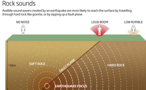
Strange booms: what's causing noises over the horizon?
Author: Kate Ravilious
Link: Click here
Abstract
Every so often, a loud booming sound is heard in the distance
without any obvious explanations. What on Earth could the culprit
be?
|
|
Diciembre de 2012
Elevated pore pressure and anomalously low stress in regions
of low frequency earthquakes along the Nankai Trough subduction
megathrust
Authors: Hiroko Kitajima, Demian M. Saffer et al
Link: Click here
Abstract
Recent seismic reflection and ocean bottom seismometer (OBS)
studies reveal broad regions of low seismic velocity along the
Nankai subduction plate boundary megathrust offshore SW Japan.
These low velocity zones (LVZ's) extend ?55 km landward from
the trench, corresponding to depths of >?10 km below sea
floor. Here, we estimate the in-situ pore pressure and stress
state within these LVZ's by combining P-wave velocities obtained
from the geophysical surveys
|
with
new well-constrained empirical relations between P-wave velocity,
porosity, and effective mean stress defined by laboratory deformation
tests on drill core samples of the incoming oceanic sediment.
We document excess pore pressures of 17-87 MPa that extend ?55
km into the subduction zone, indicating that trapped pore fluids
support ?45-91% of the overburden stress along the base of the
upper plate and surrounding major fault zones. The resulting effective
stresses in the LVZ are limited to ?1/3 of the values expected
for non-overpressured conditions. These low effective stresses
should lead to a mechanically weak and predominantly aseismic
plate boundary. The region of lowest effective stress coincides
with precisely located very low frequency earthquakes, providing
the first quantitative evidence linking these anomalous slip events
to low stress and high pore pressure. |
|
Diciembre de 2012
Early magnitude and potential damage zone estimates for the
great Mw 9 Tohoku-Oki earthquake
Authors: Simona Colombelli, Aldo Zollo et al
Link: Click here
Abstract
The Mw 9.0, 2011 Tohoku-Oki earthquake has re-opened the discussion
among the scientific community about the effectiveness of earthquake
early warning for large events. A well-known problem with real-time
procedures is the parameter saturation, which may lead to magnitude
underestimation for large earthquakes.
|
Here we measure the
initial peak ground displacement and the predominant period by
progressively expanding the time window and distance range, to
provide consistent magnitude estimates (M = 8.4) and a rapid prediction
of the potential damage area. This information would have been
available 35 s after the first P-wave detection and could have
been refined in the successive 20 s using data from more distant
stations. We show the suitability of the existing regression relationships
between early warning parameters and magnitude, provided that
an appropriate P-wave time window is used for parameter estimation.
We interpret the magnitude under-estimation as a combined effect
of high-pass filtering and frequency dependence of the main radiating
source during the rupture process. |
|
Diciembre de 2012
Microseisms and hum from ocean surface gravity waves
Authors: James Traer, Peter Gerstoft et al
Link: Click here
Abstract
Ocean waves incident on coasts generate seismic surface waves
in three frequency bands via three pathways: direct pressure
on the seafloor (primary microseisms, PM), standing waves from
interaction of incident and reflected waves (double-frequency
microseisms, DF), and swell-transformed infragravity wave interactions
(the
|
Earth's
seismic hum). Beamforming of USArray seismic data shows that the
source azimuths of the generation regions of hum, PM and DF microseisms
vary seasonally, consistent with hemispheric storm patterns. The
correlation of beam power with wave height over all azimuths is
highest in near-coastal waters. Seismic signals generated by waves
from Hurricane Irene and from a storm in the Southern Ocean have
good spatial and temporal correlation with nearshore wave height
and peak period for all three wave-induced seismic signals, suggesting
that ocean waves in shallow water commonly excite hum (via infragravity
waves), PM, and DF microseisms concurrently. |
|
Diciembre de 2012
Redes Neuronales para predecir terremotos en Chile
Autores: Jorge Reyes, Antonio Morales y Francisco Martínez
Link: Clic aquí
Abstract
En este trabajo se presenta un novedoso sistema de predicción
de terremotos. Este método, basado en la aplicación
de Redes Neuronales artificiales, ha sido utilizado para predecir
los terremotos en Chile, uno de los países con mayor
actividad sísmica en el mundo. Los parámetros
de entrada están relacionados con la Ley de Gutenberg/Richter,
la Ley de Bath, y la Ley de Omori-Utsu, parámetros fuertemente
correlacionadas con la sismicidad, como se ha demostrado en
sólidos trabajos anteriores. En este estudio presentamos
dos tipos de predicciones: la probabilidad de que ocurra un
terremoto de magnitud mayor que un umbral, y la probabilidad
de que ocurra un terremoto de magnitud ubicada dentro de un
específico intervalo, en ambos casos dentro de los próximos
5 días en las áreas analizadas. Para las cuatro
regiones sísmicas de Chile examinadas se presenta un
prototipo de Red Neuronal con epicentros dentro de un área
que va desde 0.5° × 0.5° a 1° × 1°
(máxima incerteza espacial). Los prototipos predicen
un terremoto cada vez que la probabilidad de un sismo de magnitud
mayor que un umbral es suficientemente alta. Los valores del
umbral se han ajustado con el fin de obtener la mínima
cantidad posible de falsos positivos. La confiabilidad de nuestro
método se ha corroborado con experimentos retrospectivos
por medio de pruebas estadísticas y mediante la comparación
con conocidos clasificadores de aprendizaje automatizado. La
alta tasa de éxito alcanzada apoya la idoneidad de la
aplicación de "Soft Computing" en el ámbito
de la Sismología y plantea nuevos desafíos a ser
abordados.
|
Diciembre de 2012
Neural networks to predict earthquakes in Chile
Authors: Jorge Reyes, Antonio Morales and Francisco Martínez
Link: Click here
Abstract
A new earthquake prediction system is presented in this work.
This method, based on the application of artificial neural networks,
has been used to predict earthquakes in Chile, one of the countries
with larger seismic activity. The input values are related to
the b-value, the Bath's law, and the Omori–Utsu's law,
parameters that are strongly correlated with seismicity, as
shown in solid previous works. Two kind of prediction are provided
in this study: The probability that an earthquake of magnitude
larger than a threshold value happens, and the probability that
an earthquake of a limited magnitude interval might occur, both
during the next five days in the areas analyzed. For the four
Chile's seismic regions examined, with epicenters placed on
meshes with dimensions varying from 0.5° × 0.5°
to 1° × 1°, a prototype of neuronal network is
presented. The prototypes predict an earthquake every time the
probability of an earthquake of magnitude larger than a threshold
is sufficiently high. The threshold values have been adjusted
with the aim of obtaining as few false positives as possible.
The accuracy of the method has been assessed in retrospective
experiments by means of statistical tests and compared with
well-known machine learning classifiers. The high success rate
achieved supports the suitability of applying soft computing
in this field and poses new challenges to be addressed.
|
|
Noviembre de 2012
Challenges of anticipating the 2011 Tohoku earthquake and
tsunami using coastal geology
Authors: Yuki Sawai, Yuichi Namegaya et al
Link: Click here
Abstract
Can the magnitude of a giant earthquake be estimated from paleoseismological
data alone? Attempts to estimate the size of the Jogan earthquake
of AD 869, whose tsunami affected much of the same coast as
the 2011 Tohoku tsunami, offers an excellent opportunity to
address this question, which is fundamental to assessing earthquake
and tsunami hazards at subduction zones. Between 2004 and 2010,
examining stratigraphy at 399 locations beneath paddy fields
along 180 km of coast mainly south of Sendai, we
|
learned
that a tsunami deposit associated with the AD 869 Jogan earthquake
had run inland at least 1.5 km across multiple coastal lowlands,
and that one of the lowlands had subsided during the Jogan earthquake
and an earlier earthquake as well. Radiocarbon ages just below/above
sand deposits left by the pre-Jogan tsunamis suggested recurrence
intervals in the range of 500 to 800 years. Modeling inundation
and subsidence, we estimated size of the Jogan earthquake as moment
magnitude 8.4 or larger and a fault rupture area 200 km long.
We did not consider a longer rupture, like the one in 2011, because
coastal landform and absence of a volcanic ash layer make any
Jogan layer difficult to identify along the Sanriku coast. Still,
Sendai tsunami geology might have reduced casualties by improving
evacuation maps and informing public-awareness campaigns. |
|
Noviembre de 2012
Supershear rupture on multiple faults for the Mw 8.6 Off
Northern Sumatra, Indonesia earthquake of April 11, 2012
Authors: Dun Wang, Jim Mori et al
Link: Click here
Abstract
We perform a back projection method to image the rupture propagation
and short-period energy release of the 2012 Off Northern Sumatra
|
earthquake (Mw 8.6)
using Hi-net data recorded in Japan. The results show a complex
pattern of four conjugate faults over about 180 sec. There is
a striking correspondence between the lengths and orientations
of our rupture pattern with the distribution of aftershocks. Each
of the first three stages of the rupture corresponds to a clear
lineation in the aftershocks, with lengths of 200 to 400 km. Rupture
speeds for several of the fault segments were very high, about
5 km/s, and exceed the local S-wave velocity. This is the first
example of an oceanic earthquake with supershear rupture speed.
|
|
Noviembre de 2012
Environmental magnetism: Principles and applications
Authors: Qingsong Liu, Andrew P. Roberts et al
Link: Click here
Abstract
In environmental magnetism, rock and mineral magnetic techniques
are used to investigate the formation, transportation, deposition,
and postdepositional alterations of magnetic minerals under
the influences of a wide range of environmental processes. All
materials respond in some way to an applied magnetic field,
and iron-bearing minerals are sensitive to a range of environmental
processes, which makes magnetic measurements extremely useful
for detecting signals associated with environmental processes.
Environmental magnetism has grown considerably since the mid
1970s and now contributes to research in the geosciences and
in
|
branches
of physics, chemistry, and biology and environmental science,
including research on climate change, pollution, iron biomineralization,
and depositional and diagenetic processes in sediments to name
a few applications. Magnetic parameters are used to routinely
scan sediments, but interpretation is often difficult and requires
understanding of the underlying physics and chemistry. Thorough
examination of magnetic properties and of the environmental processes
that give rise to the measured magnetic signal is needed to avoid
ambiguities, complexities, and limitations to interpretations.
In this review, we evaluate environmental magnetic parameters
based on theory and empirical results. We describe how ambiguities
can be resolved by use of combined techniques and demonstrate
the power of environmental magnetism in enabling quantitative
environmental interpretations. We also review recent developments
that demonstrate the mutual benefit of environmental magnetism
from close collaborations with biology, chemistry, and physics.
Finally, we discuss directions in which environmental magnetism
is likely to develop in the future. |
|
Noviembre de 2012
Fragmented Indian plate and vertically coherent deformation
beneath eastern Tibet
Authors: Savas Ceylan, James Ni et al
Link: Click here
Abstract
Using fundamental mode Rayleigh waves from the INDEPTH-IV and
Namche-Barwa seismic experiments for periods between 20 and
143 s, we have investigated the lithospheric structure beneath
eastern Tibet. We have found a ?200-km-wide high velocity body,
starting at ?60 km depth and roughly centered beneath the Bangong-Nijuang
Suture, which is most likely a piece of the underthrusting Indian
continental lithosphere. The sub-horizontal underthrusting of
the Indian lithosphere beneath eastern Tibet appears to be
|
accompanied by its lateral
tearing into at least two fragments, and subsequent break-off
of the westernmost portion at ?91°E-33°N. The uppermost
mantle low velocity zone we observe beneath the N. Qiangtang and
Songpan-Ganzi terranes is most probably due to warmer and thinner
lithosphere relative to southern Tibet. We attribute the low velocity
zones concentrated along the northern and southern branches of
the eastern Kunlun fault at lithospheric depths to strain heating
caused by shearing. The azimuthal fast directions at all periods
up to 143 s (?200 km peak sensitivity depth) beneath the N. Qiangtang
and Songpan-Ganzi terranes are consistent, suggesting vertically
coherent deformation between crust and uppermost mantle. Furthermore,
the low velocity zone below the Kunlun Shan reaching down to >200
km argues against a present southward continental subduction along
the southern margin of Qaidam Basin. |
|
Noviembre de 2012
Dynamic process of turbidity generation triggered by the
2011 Tohoku-Oki earthquake
Authors: Takuroh Noguchi, Wataru Tanikawa et al
Link: Click here
Abstract
We analyzed the distribution of turbidity in seawater near the
epicenter of the 2011 Tohoku earthquake (Mw 9.0) as well as
the mineral composition and grain size distribution of suspended
particles and of shallow sediments in cores from the same area.
One month after the earthquake in an area where large changes
in bathymetry accompanied the earthquake, we observed a strong
turbidity anomaly above the seafloor (maximum 5 mg/L) that greatly
exceeded
|
turbidity
measured several years before the earthquake (average 0.59 mg/L).
The suspended particles were composed of material similar to the
surface material of the sediment cores, and we inferred that they
were generated locally by a disturbance due to slope failure.
We estimated slope stability on the basis of the geophysical characteristics
of the sediment cores as well as the acceleration of the earthquake.
Our results showed that a submarine landslide could have been
induced by the very large ground acceleration of the Tohoku earthquake,
as high as 10-15 m/s2, even if the sediment layer on the sliding
surface was thin. We interpreted the turbidity anomaly observed
one month after the Tohoku earthquake as the result of shallow
submarine landsliding and stirring up of unconsolidated sediment
around the epicentral area. |
|
Noviembre de 2012
Radial 1-D seismic structures in the deep mantle in mantle
convection simulations with self-consistently calculated mineralogy
Authors: Takashi Nakagawa, Paul J. Tackley et al
Link: Click here
Abstract
Numerical thermo-chemical mantle convection simulations in a
spherical annulus geometry with self-consistently calculated
mineralogy and mineral physics are used to predict detailed
deep mantle seismic structures, particularly local radial profiles
of shear wave velocity (Vs) and bulk sound velocity (Vb). The
predicted structures are compared to seismological observations
and used to guide the interpretation of seismic observations
and to test the model. The mantle composition is described as
a mixture of MORB (Mid-Oceanic-Ridge-Basalt) and harzburgitic
end-members in the Na2O-CaO-FeO-MgO-Al2O3-SiO2 system. To assess
the influence of chemical variability, four different sets of
end-member compositions are evaluated. Results confirm that
the post-perovskite (pPv) phase causes anti-correlated S wave
and bulk sound velocities in the
|
deep mantle, due to
pPv being fast in Vs but slow in bulk sound velocity. Local 1-D
seismic profiles display great lateral variability, and often
have multiple discontinuities in the deep mantle due to MORB layers
in folded slabs, with a positive Vs anomaly and negative bulk
sound anomaly, or the perovskite-pPv phase transition. The pPv
transition is not visible inside piles of segregated MORB because
of the high temperature and small velocity contrast of pPv in
MORB. Piles of segregated MORB are seismically slow in both Vs
and bulk sound despite being expected to be fast in Vs, because
they are hotter than the surrounding material. Anelasticity has
a significant influence on profiles of Vs only in the lower thermal
boundary layer, which corresponds to below 2600 to 2800 km depth
depending on region, where temperatures are higher than the extrapolated
adiabat. These results indicate the importance of using a joint
geodynamical-mineralogical approach to predict and aid in the
interpretation of deep mantle seismic structure, because interpretations
based on seismology and mineral physics alone may be misleading
and do not capture the strong lateral variability in 1-D structure
obtained here: for example, multiple reflections arising from
folded slabs and the precise balance between thermal and compositional
influences on seismic structure. |
|
Noviembre de 2012
Uncertainty in the velocity between the mass center and surface
of Earth
Author: Donald F. Argus
Link: Click here
Abstract
Using spectral analysis and data decimation, we estimate the
uncertainty in the velocity between the cumulative mass center
of Earth (CM) and geodetic sites on Earth's surface. Knowing
this velocity is crucial for evaluating space geodetic observations
of continental uplift and subsidence in terms of postglacial
rebound and sea level rise. We find SLR observations of satellite
LAGEOS to constrain the X and Y components of the velocity of
CM to ±0.4 mm/yr and the Z component to ±0.9 mm/yr.
(95% confidence limits, X is in the direction
|
of
0°N 0°E, Y of 0°N 90°E, and Z of 90°N.) The
uncertainty in Z is high, so that the estimate includes the independent
inference made jointly using site velocities, the rigid plate
hypothesis, and models of postglacial rebound that the true velocity
of CM has a Z component of 0.5-1.0 mm/yr relative to that in ITRF2008.
Uncertainty in scale rate, an intermediate parameter in the determination
of an ITRF, is ±0.36 mm/yr for VLBI, ±0.52 mm/yr
for SLR, and ±0.20 mm/yr for GPS. The scale of GPS depends
on that of VLBI and SLR, but the low GPS uncertainty indicates
that GPS results are, for the first time, unbiased by changing
satellite Block types, evidently due to newly incorporated satellite
phase center variations. GPS constrains the velocity of CM nearly
as well as SLR, representing a technical advance given that a
GPS satellite is not a sphere and responds strongly to solar radiation
pressure. |
|
Octubre de 2012
The 2005 volcano-tectonic earthquake swarm in the Andaman
Sea: Triggered by the 2004 great Sumatra-Andaman earthquake
Authors: Bhaskar Kundu, Denis Legrand
Link: Click here
Abstract
A 6 day duration earthquakes swarm occurred in the Andaman Sea,
31 days after the giant 2004 Sumatra-Andaman earthquake (Mw
9.2). The swarm occurred less than 100 km from the eastern edge
of the 2004 earthquake rupture and is the most energetic ever
recorded in the world. The earthquakes swarm appear to have
occurred on en echelon fault system bounded by the two
|
main right-lateral strike-slip
faults, namely, the Seulimeum Strand of Sumatra Fault system (SEU)
and the West Andaman Fault (WAF). At the beginning of the swarm,
earthquakes with predominantly strike-slip focal mechanisms occurred
which were followed by earthquakes with predominantly normal faulting
focal mechanisms having significant deviatoric component. High
b value, presence of double slope in the Gutenberg-Richter relation,
presence of monogenetic submarine volcanoes in the region of the
swarm and the earthquake focal mechanisms suggest that the swarm
was of volcano-tectonic origin and fluid flow played an important
role in its occurrence. Indeed, our modeling suggests that it
was triggered by the 2004 Sumatra-Andaman earthquake through poroelastic
relaxation of the coseismic stresses. |
|
Octubre de 2012
Seismic-afterslip characterization of the 2010 MW 8.8 Maule,
Chile, earthquake based on moment tensor inversion
Authors: Hans Agurto, Andreas Rietbrock et al
Link: Click here
Abstract
On February 27th 2010, a MW8.8 earthquake struck the coast of
south-central Chile, rupturing ?500 km along the subduction
interface. Here we estimate the amount of seismically-released
afterslip (SRA) and the mechanisms underlying the distribution
of aftershocks of this megathrust earthquake. We employ data
from a temporary local network to perform regional moment tensor
(RMT) inversions. Additionally, we relocate global
|
centroid-moment-tensor
(GCMT) solutions, assembling a unified catalog covering the time
period from the mainshock to March 2012. We find that most (70%)
of the aftershocks with MW > 4 correspond to thrust events
occurring on the megathrust plane, in areas of moderate co-seismic
slip between 0.15 and 0.7 fraction of the maximum slip (Smax).
In particular, a concentration of aftershocks is observed between
the main patches of co-seismic slip, where the highest values
of SRA are observed (1.7 m). On the other hand, small events,
MW < 4, occur in the areas of largest co-seismic slip (>0.85
Smax), likely related to processes in the damage zone surrounding
the megathrust plane. Our study provides insight into the mechanics
of the seismic afterslip pattern of this large megathrust earthquake
and a quantitative approach to the distribution of aftershocks
relative to coseismic slip that can be used for similar studies
in other tectonic settings. |
|
Octubre de 2012
Decade-scale decrease in b value prior to the M9-class 2011
Tohoku and 2004 Sumatra quakes
Authors: K. Z. Nanjo, N. Hirata et al
Link: Click here
Abstract
The Gutenberg-Richter frequency-magnitude distribution of earthquakes
has become well established in seismology. The slope of the
relation between frequency and magnitude (b
|
value) is typically
1, but it often shows variations around 1. Based on an analysis
of seismicity prior to the 2011 Tohoku and 2004 Sumatra earthquakes
(both in magnitude (M) 9 class), we show that the pronounced decade-scale
decrease in b value was a common precursor to both mega-quakes
around their hypocenters. This is the first report on M9-class
quakes to confirm a change in b value, which has been predicted
based on the results of laboratory experiments. We propose that
the b value is an important indicator of an impending great earthquake,
and has great potential in terms of predicting a future large
quake off the Pacific coast of Hokkaido, Japan. |
|
Octubre de 2012
Sombrero Uplift Above the Altiplano-Puna Magma Body: Evidence
of a Ballooning Mid-Crustal Diapir
Authors: Yuri Fialko and Jill Pearse
Link: Click here
Abstract
The Altiplano-Puna ultralow-velocity zone in the central Andes,
South America, is the largest active magma body in Earth’s
continental crust. Space
|
geodetic observations
reported an uplift in the Altiplano-Puna proper at a rate of ~10
mm/year; however, the nature of the inferred inflation source
has been uncertain. We present data showing that the uplift has
persisted at a nearly constant rate over the past two decades,
and is surrounded by a broad zone of subsidence. We show that
the ongoing uplift and peripheral subsidence may result from a
large mid-crustal diapir fed by partial melt from the Altiplano-Puna
Magma Body. |
|
Octubre de 2012
An Ancient Core Dynamo in Asteroid Vesta
Authors: Roger R. Fu, Benjamin P. Weiss et al
Link: Click here
Abstract
The asteroid Vesta is the smallest known planetary body that
has experienced large-scale igneous differentiation. However,
it has been previously uncertain whether Vesta and similarly
sized planetesimals formed advecting metallic cores and dynamo
magnetic fields. Here we show that remanent magnetization in
the eucrite meteorite Allan Hills A81001 formed during cooling
on Vesta 3.69 billion years ago in a surface magnetic field
of at least 2 microteslas. This field most likely originated
from crustal remanence produced by an earlier dynamo, suggesting
that Vesta formed an advecting liquid metallic core. Furthermore,
the inferred present-day crustal fields can account for the
lack of solar wind ion-generated space weathering effects on
Vesta.
|
The
terrestrial planets are thought to have formed from the successive
growth and accretion of protoplanetary objects <1000 km in
diameter. A fraction of these protoplanets have survived to the
present day and include 4 Vesta, the second most massive asteroid
(525 km mean diameter). In particular, Vesta's high density, primordial
basaltic crust, and large size suggest that it is an intact remnant
of the early solar system that escaped catastrophic collisional
disruption. Vesta therefore provides an opportunity to characterize
the building blocks of the terrestrial planets and to study the
processes of planetesimal accretion and differentiation.
Meteorites of the howardite-eucrite-diogenite (HED) clan probably
sample the crust and upper mantle of Vesta. Geochemical studies
of HED meteorites suggest that Vesta has a fully differentiated
structure, with a metallic core ranging from 5 to 25% of the total
planetary mass that formed within ~1 to 4 million years (My) of
the beginning of the solar system. Recent volume and mass constraints
from the NASA Dawn mission provide evidence of a metallic core
between 107 and 113 km in radius. |
|
Octubre de 2012
The 2010 Mw 8.8 Maule, Chile earthquake: Nucleation and rupture
propagation controlled by a subducted topographic high
Authors: Stephen P. Hicks, Andreas Rietbrock et al
Link: Click here
Abstract
Knowledge of seismic properties in an earthquake rupture zone
is essential for understanding the factors controlling rupture
dynamics. We use data from aftershocks following the Maule earthquake
to derive a three-dimensional seismic velocity model of the
central Chile forearc. At 36°S, we find
|
a high vp (>7.0 km/s)
and high vp/vs (?1.89) anomaly lying along the megathrust at 25
km depth, which coincides with a strong forearc Bouguer gravity
signal. We interpret this as a subducted topographic high, possibly
a former seamount on the Nazca slab. The Maule earthquake nucleated
at the anomaly's updip boundary; yet high co-seismic slip occurred
where the megathrust is overlain by lower seismic velocities.
Sparse aftershock seismicity occurs within this structure, suggesting
that it disrupts normal interface seismogenesis. These findings
imply that subducted structures can be conducive to the nucleation
of large megathrust earthquakes, even if they subsequently hinder
co-seismic slip and aftershock activity. |
|
Octubre de 2012
Can a sinking metallic diapir generate a dynamo?
Authors: Julien Monteux, Nathanaël Schaeffer et al
Link: Click here
Abstract
Metallic diapirs may have strongly contributed to core formations
during the first million years of planetary evolutions. The
aim of this study is to determine whether the dynamics induced
by the diapir sinking can drive a dynamo and to characterize
the required conditions on the size of the diapir, the mantle
viscosity and the planetary latitude at which the diapir sinks.
We impose a classical Hadamard flow solution for the motion
at the interface between a spherical sinking diapir and a viscous
mantle on dynamical simulations that account for rotational
and inertial effects in
|
order
to model the flow within the diapir. The flows are confined to
a velocity layer with a thickness that decreases with increasing
rotation rate. These 3D flows are is then used as input for kinematic
dynamo simulations to determine the critical magnetic Reynolds
number for dynamo onset. Our results demonstrate that the flow
pattern inside a diapir sinking into a rotating planet can generate
a magnetic field. Large diapirs (R > 10 km) sinking in a mantle
with a viscosity ranging from 109 to 1014 Pa.s provide plausible
conditions for a dynamo. Equatorial sinking diapirs are confined
to a thicker velocity layer and are thus possibly more favorable
for dynamo generation than polar sinking diapirs. In addition
equatorial sinking diapirs produce stronger saturated magnetic
fields. However, for the range of parameters studied here, estimation
of the intensity of diapir-driven magnetic fields suggests that
they could not have contributed to the lunar or Martian crustal
paleomagnetic fields. |
|
Octubre de 2012
How changes in the tilt angle of the geomagnetic dipole affect
the coupled magnetosphere-ionosphere-thermosphere system
Authors: Ingrid Cnossen and Arthur D. Richmond
Link: Click here
Abstract
The orientation of the Earth's magnetic field has changed dramatically
during the geological past. We have investigated the effects
of changes in dipole tilt angle on the magnetosphere, ionosphere,
and thermosphere, using the Coupled Magnetosphere-Ionosphere-Thermosphere
(CMIT) model. The dipole tilt angle modulates the efficiency
of solar wind-magnetosphere coupling, by influencing the diurnal
variation in the angle ? between the dipole axis and the GSM
z axis. This influences how much Joule heating occurs at high
magnetic
|
latitudes. The dipole
tilt angle also controls the geographic distribution of the Joule
heating, as it determines the geographic latitude of the magnetic
poles. Changes in the amount and distribution of Joule heating
with tilt an`gle produce further changes in temperature and neutral
winds. The latter affect the O/N2 ratio, which in turn modifies
the peak electron density of the F2 layer, NmF2. All these effects
are most important when the Interplanetary Magnetic Field (IMF)
is southward, while being almost negligible under northward IMF.
However, a change in dipole tilt also changes the inclination
of the magnetic field, which affects the vertical component of
ionospheric plasma diffusion along the magnetic field, regardless
of the IMF direction. Changes in vertical plasma diffusion are
responsible for ?2/3 of the changes in NmF2 and most of the low
to midlatitude changes in hmF2 under southward IMF and for most
of the changes in both variables under northward IMF. Thermal
contraction may be responsible for high-latitude decreases in
hmF2 with increasing tilt angle under southward IMF. |
|
Octubre de 2012
The history of Mars' dynamo as revealed by modeling magnetic
anomalies near Tyrrhenus Mons and Syrtis Major
Authors: C. Milbury, G. Schubert et al
Link: Click here
Abstract
The lack of magnetic anomalies within the major impact basins
(Hellas, Argyre, and Isidis) has led many investigators to the
conclusion that Mars' dynamo shut down prior to the time when
these basins formed (?4.0 Ga). We test this hypothesis by analyzing
gravity and magnetic anomalies in the regions surrounding Tyrrhenus
Mons and Syrtis Major, two volcanoes that were active during
the late Noachian and Hesperian. We model magnetic anomalies
that are associated with gravity anomalies and generally find
that sources located
|
below
Noachian surface units tend to favor paleopoles near the equator
and sources located below Hesperian surface features favor paleopoles
near the geographical poles, suggesting polar wander during the
Noachian- Hesperian. Both paleopole clusters have positive and
negative polarities, indicating reversals of the field during
the Noachian and Hesperian. Magnetization of sources below Hesperian
surfaces is evidence that the dynamo persisted beyond the formation
of the major impact basins. The demagnetization associated with
the volcanic construct of Syrtis Major implies dynamo cessation
occurred while it was geologically active approximately 3.6 billion
years ago. Timing of dynamo activity is fundamentally linked to
Mars' climate via the stability of its atmosphere, and is coupled
to the extent and duration of surface geologic activity. Thus,
the dynamo history is key for understanding both when Mars was
most geologically active and when it may have been most hospitable
to life. |
|
Octubre de 2012
The 2012 Ferrara Seismic Sequence: Regional Crustal Structure,
Earthquake Sources, and Seismic Hazard
Authors: Luca Malagnini, Robert B. Herrmann et al
Link: Click here
Abstract
Inadequate seismic design codes can be dangerous, particularly
when they underestimate the true hazard. In this study we use
data from a sequence of moderate-sized earthquakes in northeast
Italy to validate and test a regional wave propagation model
which, in turn, is used to understand some weaknesses of the
current design spectra. Our velocity model, while
|
regionalized and somewhat
ad hoc, is consistent with geophysical observations and the local
geology. In the 0.02-0.1 Hz band, this model is validated by using
it to calculate moment tensor solutions of 20 earthquakes (5.6
{greater than or equal to} MW {greater than or equal to} 3.2)
in the 2012 Ferrara, Italy, seismic sequence. The seismic spectra
observed for the relatively small mainshock significantly exceeded
the design spectra to be used in the area for critical structures.
Observations and synthetics reveal that the ground motions are
dominated by long-duration surface waves, which, apparently, the
design codes do not adequately anticipate. In light of our results,
the present seismic hazard assessment in the entire Pianura Padana,
including the city of Milan, needs to be re-evaluated. |
|
Octubre de 2012
Rapid Acceleration Leads to Rapid Weakening in Earthquake-Like
Laboratory Experiments
Authors: J. C. Chang, D. A. Lockner et al
Link: Click here
Abstract
After nucleation, a large earthquake propagates as an expanding
rupture front along a fault. This front activates countless
fault patches that slip by consuming energy stored in Earth's
crust. We simulated the slip of a fault patch by rapidly
|
loading
an experimental fault with energy stored in a spinning flywheel.
The spontaneous evolution of strength, acceleration, and velocity
indicates that our experiments are proxies of fault-patch behavior
during earthquakes of moment magnitude (Mw) = 4 to 8. We show
that seismically determined earthquake parameters (e.g., displacement,
velocity, magnitude, or fracture energy) can be used to estimate
the intensity of the energy release during an earthquake. Our
experiments further indicate that high acceleration imposed by
the earthquake's rupture front quickens dynamic weakening by intense
wear of the fault zone. |
|
Octubre de 2012
Earthquakes in the Lab
Authors: Toshihiko Shimamoto and Tetsuhiro Togo
Link: Click here
Abstract
Understanding how earthquakes of different sizes occur is one
of the most challenging questions in fault and earthquake mechanics.
On page 101 of this issue, Chang et al. (1) report the results
of a carefully conducted experiment using a spinning flywheel
attached to a high-velocity frictional testing machine to produce
what they term an earthquake-like slip event. By changing the
rate of revolution of
|
the
flywheel, the amount of kinetic energy transferred to the simulated
fault in Sierra White granite or Kasota dolomite could be varied
by about six orders of magnitude and could produce a series of
frictional slips ranging from 0.003 to 4.6 m, corresponding to
a moment magnitude range of Mw = 4 to 8 with respect to the range
of fault displacements. The power relationship between energy
input and displacement is similar to that found for natural earthquakes.
Also, the slip produced by the flywheel is characterized by very
rapid initial acceleration followed by gradual deceleration, somewhat
similar to slip history recognized for natural earthquakes (2).
Such experiments will arouse discussions about whether they are
realistic proxies of natural earthquakes. |
|
Octubre de 2012
Earthquake Recurrence Models Fail when Earthquakes Fail to
Reset the Stress Field
Authors: Thessa Tormann, Stefan Wiemer et al
Link: Click here
Abstract
Parkfield's regularly occurring M6 mainshocks, about every 25
years, have over two decades stoked seismologists' hopes to
successfully predict an earthquake of significant size. However,
with the longest known inter-event time of 38 years, the latest
M6 in the series (28 Sep 2004) did not conform to any of the
applied forecast models,
|
questioning
once more the predictability of earthquakes in general. Our study
investigates the spatial pattern of b-values along the Parkfield
segment through the seismic cycle and documents a stably stressed
structure. The forecasted rate of M6 earthquakes based on Parkfield's
microseismicity b-values corresponds well to observed rates. We
interpret the observed b-value stability in terms of the evolution
of the stress field in that area: the M6 Parkfield earthquakes
do not fully unload the stress on the fault, explaining why time
recurrent models fail. We present the 1989 M6.9 Loma Prieta earthquake
as counter example, which did release a significant portion of
the stress along its fault segment and yields a substantial change
in b-values. |
|
Octubre de 2012
Decay and expansion of the early aftershock activity following
the 2011, Mw9.0 Tohoku earthquake
Authors: O. Lengliné, B. Enescu et al
Link: Click here
Abstract
The 2011, Mw9.0 Tohoku earthquake was followed by an abundant
amount of seismicity providing a unique opportunity to analyze
the triggering mechanism of great earthquakes. Although the
Tohoku earthquake occurred close to a dense seismic network,
many aftershocks that occurred
|
in the first few hours
after the mainshock are not recorded in the earthquake catalogs.
Here we use a template waveform approach to recover as many as
possible missing events in the first 12 hours following the Tohoku
mainshock. Our analysis is able to detect about 1.4 times more
events than those listed in the High Sensitivity Seismograph (Hi-net)
earthquake catalog. Combining our new dataset with earthquakes
that occurred at latter times, we are able to observe a continuous
decay of the aftershock rate and along strike expansion of aftershock
area. We relate the latter observation to the occurrence of post-seismic
slip over the deep interface. |
|
Septiembre de 2012
Shock vaporization of silica and the thermodynamics of planetary
impact events
Authors: R. G. Kraus, S. T. Stewart et al
Link: Click here
Abstract
The most energetic planetary collisions attain shock pressures
that result in abundant melting and vaporization. Accurate predictions
of the extent of melting and vaporization require knowledge
of vast regions of the phase diagrams of the constituent materials.
To reach the liquid-vapor phase boundary of silica, we conducted
uniaxial shock-and-release experiments, where quartz was shocked
to a state sufficient to initiate vaporization upon isentropic
decompression (hundreds of GPa). The apparent temperature of
the decompressing fluid was measured with a streaked optical
pyrometer, and the bulk density was inferred by stagnation onto
a standard
|
window.
To interpret the observed post-shock temperatures, we developed
a model for the apparent temperature of a material isentropically
decompressing through the liquid-vapor coexistence region. Using
published thermodynamic data, we revised the liquid-vapor boundary
for silica and calculated the entropy on the quartz Hugoniot.
The silica post-shock temperature measurements, up to entropies
beyond the critical point, are in excellent qualitative agreement
with the predictions from the decompressing two-phase mixture
model. Shock-and-release experiments provide an accurate measurement
of the temperature on the phase boundary for entropies below the
critical point, with increasing uncertainties near and above the
critical point entropy. Our new criteria for shock-induced vaporization
of quartz are much lower than previous estimates, primarily because
of the revised entropy on the Hugoniot. As the thermodynamics
of other silicates are expected to be similar to quartz, vaporization
is a significant process during high-velocity planetary collisions.
|
|
Septiembre de 2012
Local spectral variability and the origin of the Martian
crustal magnetic field
Authors: Kevin W. Lewis and Frederik J. Simons
Link: Click here
Abstract
The crustal remanent magnetic field of Mars remains enigmatic
in many respects. Its heterogeneous surface distribution points
to a complex history of formation and modification, and has
been resistant to attempts at identifying magnetic paleopoles
and constraining the geologic origin of crustal sources. We
use a multitaper technique to quantify the spatial diversity
of the field via the localized magnetic power
|
spectrum,
which allows us to isolate more weakly magnetized regions and
characterize them spectrally for the first time. We find clear
geographical differences in spectral properties and parameterize
them in terms of source strengths and equivalent-layer decorrelation
depths. These depths to the base of the magnetic layer in our
model correlate with independent crustal-thickness estimates.
The correspondence indicates that a significant fraction of the
martian crustal column may contribute to the observed field, as
would be consistent with an intrusive magmatic origin. We identify
several anomalous regions, and propose geophysical mechanisms
for generating their spectral signatures. |
|
Septiembre de 2012
On secular changes of correlation between geomagnetic indices
and variations in solar activity
Authors: Jean-Louis Le Mouël, Elena Blanter et al
Link: Click here
Abstract
Geomagnetic indices can be divided in two families, sometimes
called "mean" and "range" families, which
reflect different interactions between solar and terrestrial
processes on time scales ranging from hourly to secular and
longer. We are interested here in trying to evaluate secular
change in the correlations between these indices and variations
in solar activity as indicators of secular changes in solar
behavior. We use on one hand daily values of geomagnetic indices
Dst and ? (members of the "mean" family), and Ap and
aa (members of the "range" family), and on the other
hand solar indices WN (sunspot number), F10.7 (radio flux),
interplanetary magnetic field B and solar wind speed v over
the period 1955-2005. We calculate correlations between pairs
of
|
geomagnetic
indices, between pairs of solar indices (including the composite
Bv2), and between pairs consisting in a geomagnetic vs a solar
index, all averaged over one to eleven years. The relationship
between geomagnetic indices depends on the evolution of solar
activity; strong losses of correlation occur during the declining
phase of solar cycle 20 and in solar cycle 23. We confirm the
strong correlation between aa and Bv2 and to a lesser extent between
Dst and B. On the other hand, correlations between aa or Dst and
v are non-stationary and display strong increases between 1975
and 2000. Some geomagnetic indices can be used as proxies for
the behavior of solar wind indices for times when these were not
available. We discuss possible physical origins of sub-decadal
to secular evolutions of correlations and their relation with
the character of solar activity (correlation of DP2 substorms
and main storm occurrence, generation of toroidal field of a new
cycle during descending phase of old cycle and prediction of next
cycle, and also links with coupling of nonlinear oscillators and
abrupt regime changes). |
|
Septiembre de 2012
The role of triggering by static stress transfer during geothermal
reservoir stimulation
Authors: M. Schoenball, C. Baujard et al
Link: Click here
Abstract
During creation of an Enhanced Geothermal System, massive fluid
injections are conducted to induce fracture shear which generates
reservoir permeability. In this study we analyze coseismic static
stress transfer caused by induced seismic events during a stimulation
at the European research project at Soultz-sous-Forêts
(Alsace, France). For this purpose we developed an efficient
method to calculate coseismic static stress changes from an
elliptical slip distribution on a circular fracture using superposition
of rectangular sources, which enables us to apply an analytical
solution for fast computation. This
|
method is applied on
a data set of 715 focal mechanisms derived from seismic recordings
of the stimulation of the well GPK2 to calculate temporal evolution
of static stress transfer. We find that the resulting structure
of coseismic stress changes can be divided into three parts: a
quiet zone where no spreading of seismicity occurs, an active
zone within the created reservoir with ongoing fracturing and
a process zone where the growth of the reservoir occurs. Static
stress changes in the active zone are of the order of 1 MPa, both
positive and negative, but may exceed this value considerably
on a local scale. Analysis of stress changes from a cluster of
events that occurred after shut-in lets us conclude that triggering
by coseismic static stress changes is possible for some events.
Our analysis shows that triggering by static stress transfer plays
a minor role for injection induced seismicity in a volumetric
reservoir, whereas it can be quite effective for rupture propagation
along single large fault zones. |
|
Septiembre de 2012
A real-time forecast service for the ionospheric equatorial
zonal electric field
Authors: C. Manoj and S. Maus
Link: Click here
Abstract
The zonal electric field is the primary driver of two important
features of the equatorial ionosphere: (1)The Equatorial Ionization
Anomaly (EIA), and (2) plasma density irregularities, also known
as spread-F. During propagation through the ionosphere, communication
and navigation radio signals are attenuated, delayed and scattered
by these ionospheric features. Prediction of the zonal electric
field is therefore a key to the real-time specification of the
ionosphere. We divide the zonal electric field into a climatological
contribution plus the prompt-penetration contribution predicted
|
by a transfer-function model applied to the interplanetary electric
field measured by the Advanced Composition Explorer (ACE) satellite.
The zonal electric field is predicted about one hour in advance,
covering all local times and longitudes. The real-time prediction
is available as a Google application at http://www.geomag.us/models/PPEFM/RealtimeEF.html.
The benefit of this application to space weather forecasting is
twofold: As the driver of the equatorial plasma fountain, the
predicted zonal electric field is a leading indicator by 2-3 h
of the EIA and the Total Electron Content (TEC) of the equatorial
ionosphere. Second, rapid uplift of the ionosphere by strong eastward
electric field is known to induce spread-F. Prediction of enhanced
prompt penetration electric field in the eastward direction therefore
enables the forecast of radio communication and navigation outages
in the equatorial region. |
|
Septiembre de 2012
Magnetotelluric monitoring of a fluid injection: Example
from an enhanced geothermal system
Authors: J. R. Peacock, S. Thiel et al
Link: Click here
Abstract
Enhanced geothermal systems (EGS) are on the verge of becoming
commercially viable for power production, where advancements
in subsurface characterization are imperative to develop EGS
into a competitive industry. Theory of an EGS is simple, pump
fluids into thermally enhanced lithology and extract the hot
fluids to produce energy. One significant complication in EGS
development is estimating where injected fluids flow in the
subsurface. Micro-seismic surveys can provide
|
information about where
fractures opened, but not fracture connectivity nor fluid inclusion.
Electromagnetic methods are sensitive to conductivity contrasts
and can be used as a supplementary tool to delineate reservoir
boundaries. In July, 2011, an injection test for a 3.6 km deep
EGS at Paralana, South Australia was continuously monitored by
both micro-seismic and magnetotellurics (MT). Presented are the
first results from continuous MT measurements suggesting transient
variations in subsurface conductivity structure generated from
the introduction of fluids at depth can be measured. Furthermore,
phase tensor representation of the time dependent MT response
suggests fluids migrated in a NE direction from the injection
well. Results from this experiment supports the extension of MT
to a monitoring tool for not only EGS but other hydraulic stimulations.
|
|
Septiembre de 2012
Is there a 60-year oscillation in global mean sea level?
Authors: Don P. Chambers, Mark A. Merrifield et al
Link: Click here
Abstract
We examine long tide gauge records in every ocean basin to examine
whether a quasi 60-year oscillation observed in global mean
sea level (GMSL) reconstructions reflects a true global oscillation,
or an artifact associated with a small number of gauges. We
find that there is a significant oscillation with a period around
60-years in the majority of the tide gauges examined during
the 20th Century, and that it appears in
|
every
ocean basin. Averaging of tide gauges over regions shows that
the phase and amplitude of the fluctuations are similar in the
North Atlantic, western North Pacific, and Indian Oceans, while
the signal is shifted by 10 years in the western South Pacific.
The only sampled region with no apparent 60-year fluctuation is
the Central/Eastern North Pacific. The phase of the 60-year oscillation
found in the tide gauge records is such that sea level in the
North Atlantic, western North Pacific, Indian Ocean, and western
South Pacific has been increasing since 1985-1990. Although the
tide gauge data are still too limited, both in time and space,
to determine conclusively that there is a 60-year oscillation
in GMSL, the possibility should be considered when attempting
to interpret the acceleration in the rate of global and regional
mean sea level rise. |
|
Septiembre de 2012
Xenopumices from the 2011-2012 submarine eruption of El Hierro
(Canary Islands, Spain): Constraints on the plumbing system
and magma ascent
Authors: S. Meletlidis, A. Di Roberto et al
Link: Click here
Abstract
Textures, petrography and geochemical compositions of products
emitted during the onset of the 2011-2012 submarine eruption
(15 October, 2011) off the coast of El Hierro have been investigated
to get information on interaction mechanism between the first
rising magma and the crust during the onset of the eruption
as well as to get information on magma storage and
|
plumbing systems beneath
El Hierro volcano. Studied products consist of 5-50 cm bombs with
an outer black to greenish, vesicular crust with bulk basanite
composition containing pumiceous xenoliths (xenopumices). Our
results show that xenopumices are much more heterogeneous that
previously observed, since consist of a macro-scale mingling of
a gray trachyte and white rhyolite. We interpreted xenopumices
as resulting from the interaction (heating) between the basanitic
magma feeding the eruption, a stagnant trachytic magma pocket/s
and an associated hydrothermally altered halo with rhyolitic composition.
Our findings confirm the importance of the study of the early
products of an eruption since they can contain crucial information
on the plumbing system geometry and the mechanism of magma ascent.
|
|
Septiembre
de 2012
¿Podemos confiar en las pruebas de detección
de clusters de teremotos?
Autor: Felipe Dimer de Oliveira
Link: Clic aquí
Abstract
Poner a prueba el catálogo mundial de terremotos en busca
de señales de atributos no Poissonianos, ha sido un área
de intensas investigaciones, en especial desde el terremoto
de Tohoku del año 2011. El procedimiento usual consiste
en probar estadísticamente que el catálogo mundial
es bien explicado por un proceso Poissoniano. En este paper
analizamos uno de los aspectos de este problema que ha sido
ignorado en la literatura: la capacidad de tales pruebas para
detectar características no Poissonianas, si es que éstas
existen. Aquí estamos hablando de los Errores Estadísticos
de Probabilidad de Tipo II. Nosotros argumentamos en este artículo
que la baja frecuencia de los eventos de gran magnitud y la
corta extensión temporal de nuestros catálogos
reduce la capacidad de las pruebas estadísticas y las
vuelve incapaces de proporcionar una inequívoca respuesta
a esta pregunta. Demostramos nuestras afirmaciones mediante
un contraejemplo basado en un proceso estocástico que
ha sido construído de un modo "clusterizado"
y analizando la resultante distribución de los p-values
dados por una selección de ciertas pruebas estadísticas
que pueden ser encontradas en la literatura.
|
Septiembre de 2012
Can we trust earthquake cluster detection tests?
Author: Felipe Dimer de Oliveira
Link: Click here
Abstract
Testing the global earthquake catalogue for indications of non-Poissonian
attributes has been an area of intense research, especially
since the 2011 Tohoku earthquake. The usual approach is to test
statistically the hypothesis that the global earthquake catalogue
is well explained by a Poissonian process. In this paper we
analyse one aspect of this problem which has been disregarded
by the literature: the power of such tests to detect non-Poissonian
features if they exist; that is, the probability of type II
statistical errors. We argue in this article that the low frequency
of large events and the brevity of our earthquake catalogues
reduce the power of the statistical tests and render them unable
to provide an unequivocal answer to this question. We do this
using a counter example of a stochastic process that is clustered
by construction and by analysing the resulting distribution
of p-values given by a selection of statistical tests related
to those found in the literature.
|
|
|
|
Septiembre de 2012
A computational and theoretical analysis of falling frequency
VLF emissions
Authors: David Nunn and Yoshiharu Omura
Link: Click here
Abstract
Recently much progress has been made in the simulation and theoretical
understanding of rising frequency triggered emissions and rising
chorus. Both PIC and Vlasov VHS codes produce risers in the
region downstream from the equator toward which the VLF waves
are traveling. The VHS code only produces fallers or downward
hooks with difficulty due to the coherent nature of wave particle
interaction across the equator. With the VHS code we now confine
the interaction region to be the region upstream from the equator,
where inhomogeneity factor S is positive. This suppresses correlated
wave particle interaction
|
effects across the equator and the tendency
of the code to trigger risers, and permits the formation of
a proper falling tone generation region. The VHS code now easily
and reproducibly triggers falling tones. The evolution of resonant
particle current JE in space and time shows a generation point
at ?5224 km and the wavefield undergoes amplification of some
25 dB in traversing the nonlinear generation region. The current
component parallel to wave magnetic field (JB) is positive,
whereas it is negative for risers. The resonant particle trap
shows an enhanced distribution function or 'hill', whereas risers
have a 'hole'. According to recent theory (Omura et al., 2008,
2009) sweeping frequency is due primarily to the advective term.
The nonlinear frequency shift term is now negative (??12 Hz)
and the sweep rate of ?800 Hz/s is approximately nonlinear frequency
shift divided by TN, the transition time, of the order of a
trapping time.
|
|
Agosto de 2012
Geodetic constraints on afterslip characteristics following
the March 9, 2011, Sanriku-oki earthquake, Japan
Authors: Yusaku Ohta, Ryota Hino et al
Link: Click here
Abstract
A magnitude 7.3 foreshock occurred at the subducting Pacific
plate interface on March 9, 2011, 51 h before the magnitude
9.0 Tohoku earthquake off the Pacific coast of Japan. We propose
a coseismic and postseismic afterslip model of the magnitude
7.3 event based on a global positioning system network and ocean
|
bottom pressure gauge
sites. The estimated coseismic slip and afterslip areas show complementary
spatial distributions; the afterslip distribution is located up-dip
of the coseismic slip for the foreshock and northward of hypocenter
of the Tohoku earthquake. The slip amount for the afterslip is
roughly consistent with that determined by repeating earthquake
analysis carried out in a previous study. The estimated moment
release for the afterslip reached magnitude 6.8, even within a
short time period of 51h. A volumetric strainmeter time series
also suggests that this event advanced with a rapid decay time
constant compared with other typical large earthquakes. |
|
Agosto de 2012
Powering Ganymede's dynamo
Authors: X. Zhan and G. Schubert
Link: Click here
Abstract
It is generally believed that Ganymede's core is composed of
an Fe-FeS alloy and that convective motions inside it are responsible
for generating the satellite's magnetic field. Analysis of the
melting behavior of Fe-FeS alloys at Ganymede's core pressures
suggests that, besides the growth of a solid inner core, convection
can be driven by two novel mechanisms: Fe snow and FeS flotation.
To advance our understanding of magnetic field generation in
Ganymede, we construct dynamo models in which deep inner core
growth, Fe-snow and FeS flotation drive
|
convection.
Although a dynamo can be found in each of these cases, the dynamos
have different characteristics. For example, some dynamos are
dipole dominant and others are not. It is found that multipole-dominant
magnetic fields are generated in all Fe-snow cases, while dipole
dominant dynamos are found in FeS flotation cases and in inner
core growth cases. Ganymede's present dipole-dominant magnetic
field suggests that the Fe-snow process does not play a primary
role in driving Ganymede's core convection. The reason that Fe-snow
driven convection does not produce a dipole-dominant dynamo can
be related to the buoyancy flux. In Fe-snow cases, the buoyancy
source is located at the core-mantle boundary (CMB), and the buoyancy
flux peaks there, while in the other two cases, the buoyancy source
is located at the inner core boundary where the buoyancy flux
peaks. |
|
Agosto de 2012
The crystal fabric of ice from full-waveform borehole sonic
logging
Authors: Alessio Gusmeroli, Erin C. Pettit et al
Link: Click here
Abstract
In an ice sheet, a preferred crystal orientation fabric affects
deformation rates because ice crystals are strongly anisotropic:
shear along the basal plane is significantly easier than shear
perpendicular to the basal plane. The effect of fabric can be
as important as temperature in defining deformation rates. Fabric
is typically measured using analysis of thin sections under
the microscope with co-polarized light. Due to the time-consuming
and destructive nature of these measurements, however, it is
difficult to capture
|
the spatial variation
in fabric necessary for evincing ice sheet flow patterns. Because
an ice crystal is similarly elastically anisotropic, the speed
of elastic waves through ice can be used as a proxy for quantify
anisotropy. We use borehole sonic logging measurements and thin
section data from Dome C, East Antarctica to define the relations
between apparent fabric and borehole measured elastic speeds (compressional
VP and vertically polarized shear VSV). These relations, valid
for single maximum fabrics, allow in-situ, depth-continuous fabric
estimates of unimodal fabric strength from borehole sonic logging.
We describe the single maximum fabric using a1: the largest eigenvalue
of the second-order orientation tensor. For ice at -16°C and
a1 in the 0.7-1 range the relations are VP = 248 a13.7 + 3755
m s-1 and VSV = -210a17.3 + 1968 m s-1. |
|
Agosto de 2012
Theory and numerical modeling of electrical self-potential
signatures of unsaturated flow in melting snow
Authors: B. Kulessa, D. Chandler et al
Link: Click here
Abstract
We have developed a new theory and numerical model of electrical
self-potential (SP) signals associated with unsaturated flow
in melting snow. The model is applicable to continuous natural
melt as well as transient flow phenomena such as meltwater pulses
and is tested using laboratory column experiments. SP signals
fundamentally depend on the temporal evolution of snow porosity
and meltwater flux, electrical conductivity (EC), and pH. We
infer a reversal of the sign of the zeta potential (a fundamental
electrical property of grain surfaces in porous media) consistent
with well-known elution sequences of ions that cause progressive
increases and decreases in meltwater pH and EC, respectively.
Injection of fully melted snow
|
samples,
containing the entire natural range of ions, into melting snow
columns caused additional temporary reversals of the sign of the
zeta potential. Widely used empirical relationships between effective
saturation, meltwater fraction, EC, and pH, as well as snow porosity,
grain size, and permeability, are found to be robust for modeling
purposes. Thus nonintrusive SP measurements can serve as proxies
for snow meltwater fluxes and the temporal evolution of fundamental
snow textural, hydraulic, or water quality parameters. Adaptation
of automated multisensor SP acquisition technology from other
environmental applications thus promises to bridge the widely
acknowledged gap in spatial scales between satellite remote sensing
and point measurements of snow properties. SP measurements and
modeling may therefore contribute to solving a wide range of problems
related to the assessment of water resource availability, avalanche
or flood risk, or the amplification of climatic forcing of ice
shelf, ice sheet, or glacier dynamics. |
|
Agosto de 2012
Geoneutrinos and the radioactive power of the Earth
Author: S. T. Dye
Link: Click here
Abstract
Chemical and physical Earth models agree little as to the radioactive
power of the planet. Each predicts a range of radioactive powers,
overlapping slightly with the other at about 24 TW, and together
spanning 14–46 TW. Approximately 20% of this radioactive
power (3–8 TW) escapes to space in the form of geoneutrinos.
The remaining 11–38 TW heats the planet with significant
geodynamical consequences, appearing as the radiogenic component
of the 43–49 TW surface heat flow. The nonradiogenic component
of the surface heat flow (5–38 TW) is presumably primordial,
a legacy of the formation and early evolution of the planet.
A constraining measurement of radiogenic heating provides insights
to the thermal history of the Earth and potentially discriminates
chemical and physical
|
Earth models. Radiogenic
heating in the planet primarily springs from unstable nuclides
of uranium, thorium, and potassium. The paths to their stable
daughter nuclides include nuclear beta decays, producing geoneutrinos.
Large subsurface detectors efficiently record the energy but not
the direction of the infrequent interactions of the highest-energy
geoneutrinos, originating only from uranium and thorium. The measured
energy spectrum of the interactions estimates the relative amounts
of these heat-producing elements, while the intensity estimates
planetary radiogenic power. Recent geoneutrino observations in
Japan and Italy find consistent values of radiogenic heating.
The combined result mildly excludes the lowest model values of
radiogenic heating and, assuming whole mantle convection, identifies
primordial heat loss. Future observations have the potential to
measure radiogenic heating with better precision, further constraining
geological models and the thermal evolution of the Earth. This
review presents the science and status of geoneutrino observations
and the prospects for measuring the radioactive power of the planet.
|
|
Agosto
de 2012
Probabilistic prediction of barrier-island response to hurricanes
Authors: Nathaniel G. Plant and Hilary F. Stockdon
Link: Click here
Abstract
Prediction of barrier-island response to hurricane attack is
important for assessing the vulnerability of communities, infrastructure,
habitat, and recreational assets to the impacts of storm surge,
waves, and erosion. We have demonstrated that a conceptual model
intended to make qualitative predictions of the type of beach
response to storms (e.g., beach erosion, dune erosion, dune
overwash, inundation) can be reformulated in a Bayesian network
to make quantitative predictions of the morphologic response.
In an application of this approach at Santa Rosa Island, FL,
predicted dune-crest elevation changes in response to Hurricane
Ivan explained about 20% to 30% of the
|
observed
variance. An extended Bayesian network based on the original conceptual
model, which included dune elevations, storm surge, and swash,
but with the addition of beach and dune widths as input variables,
showed improved skill compared to the original model, explaining
70% of dune elevation change variance and about 60% of dune and
shoreline position change variance. This probabilistic approach
accurately represented prediction uncertainty (measured with the
log likelihood ratio), and it outperformed the baseline prediction
(i.e., the prior distribution based on the observations). Finally,
sensitivity studies demonstrated that degrading the resolution
of the Bayesian network or removing data from the calibration
process reduced the skill of the predictions by 30% to 40%. The
reduction in skill did not change conclusions regarding the relative
importance of the input variables, and the extended model's skill
always outperformed the original model. |
|
Agosto de 2012
Postseismic motion after the 2001 MW 7.8 Kokoxili earthquake
in Tibet observed by InSAR time series
Authors:Yangmao Wen and Zhenhong Li et al
Link: Click here
Abstract
On November 14th 2001, a Mw 7.8 earthquake occurred in the Kokoxili
region of northern Tibet. The earthquake ruptured more than
400 km along the western part of the Kunlun fault with a maximum
of 8 m left-lateral slip. In this paper, we use a multitemporal
Interferometric SAR (InSAR) time series technique to map the
postseismic motion following the large Kokoxili event. SAR data
from Envisat descending orbits along five adjacent tracks covering
almost the entire ruptured fault length are used to calculate
the displacement time series for a period between 2 and 6 years
after the earthquake. A peak-to-trough signal of 8 cm in the
radar line of sight is observed during the period between 2003
and 2008. Two different mechanisms are employed to
|
explain the observed
surface displacements, namely afterslip and viscoelastic relaxation.
The observations inverted for afterslip on and below the coseismic
rupture plane shows that the maximum slip in the afterslip model
is 0.6 m. The position of the maximum postseismic slip is located
in the middle of two relatively high coseismic slip patches, which
suggests that afterslip is a plausible mechanism. Models of viscoelastic
stress relaxation in a Maxwell half-space give a best fitting
viscosity for the mid-to-lower crust of 2-5 × 10¹⁹ Pa s,
and the principal postseismic relaxation process is due to viscous
flow in the lower crust to upper mantle. However, the InSAR observations
are incapable of distinguishing between localized (afterslip)
and distributed (viscoelastic relaxation) deformation. And the
lowest misfits are produced by mixed models of viscoelastic relaxation
in the mantle below 70 km and afterslip in the crust. Modeling
of viscoelastic relaxation in a Maxwell half-space, and also a
mixed mechanism model, enables us to place an effective viscosity
of 2 × 10¹⁹ Pa s on the lower crust to mantle of northern
Tibet. |
|
|
|
Agosto de 2012
Interseismic strain accumulation along the western boundary
of the Indian subcontinent
Authors: Walter Szeliga, Roger Bilham et al
Link: Click here
Abstract
Despite an overall sinistral slip rate of ?3 cm/yr, few major
earthquakes have occurred in the past 200 years along the Chaman
fault system, the western boundary of the India Plate with the
Eurasia Plate. GPS and InSAR data reported here indicate sinistral
shear velocities of 8-17 mm/yr across the westernmost branches
of the fault system, suggesting that a significant fraction
of the plate boundary slip is distributed in the fold and fault
belt to the east. At its southernmost on-land segment (?26°N),
near the triple junction between the Arabia, Eurasia, and India
Plates, we find the velocity across the Ornach Nal fault is
|
15.1+13.4+16.9 mm/yr,
with a locking depth probably less than 3 km. At latitude 30°N
near the town of Chaman, Pakistan, where a M6.5 earthquake occurred
in 1892, the velocity is 8.5+6.8+10.3 mm/yr and the fault is locked
at approximately 3.4 km depth. At latitude 33°N and further
north, InSAR data indicate a velocity across the Chaman fault
of 16.8 ± 2.7 mm/yr. The width of the plate boundary varies
from several km in the south where we observe ?2 mm/yr of convergence
near the westernmost strike-slip faults, to a few hundreds of
km in the north where we observe 6-9 mm/yr of convergence, and
where the faulting becomes distinctly transpressional. The shallow
locking depth along much of the transform system suggests that
earthquakes larger than those that have occurred in the historical
record would be unexpected, and that the recurrence interval of
those earthquakes that have occurred is of the order of one or
two centuries, similar in length to the known historical record. |
|
Agosto de 2012
Pyrite alteration and neoformed magnetic minerals in the
fault zone of the Chi-Chi earthquake (Mw 7.6, 1999): Evidence
for frictional heating and co-seismic fluids
Authors: Yu-Min Chou, Sheng-Rong Song et al
Link: Click here
Abstract
During an earthquake, physical and chemical transformations
lead to alteration and formation of minerals in the gouge layer.
Altered and neoformed minerals can be used as tracers of some
earthquake processes. In this study, we investigate pyrite and
magnetic minerals within the host Chinshui siltstone and the
16-cm-thick gouge. This gouge hosts the principal slip zone
of Chi-Chi earthquake (Mw 7.6, 1999). In the Chinshui siltstone,
pyrite framboids of various sizes and euhedral pyrite are observed.
The
|
magnetic mineral assemblage comprises stoichiometric
magnetite, greigite, and fine-grained pyrrhotite. The pyrite
content is generally reduced in the gouge compared to the wall
rock. The magnetic mineral assemblage in the gouge consists
of goethite, pyrrhotite, and partially oxidized magnetite. The
pyrrhotite, goethite and some magnetite are neoformed. Pyrrhotite
likely formed from high temperature decomposition of pyrite
(>500°C) generated during co-seismic slip of repeated
earthquakes. Goethite is inferred to have formed from hot aqueous
co-seismic fluid (>350°C) in association with the 1999
Chi-Chi event. Elevated fluid temperatures can also explain
the partial alteration of magnetite and the retrograde alteration
of some pyrrhotite to pyrite. We suggest that characterization
of neoformed magnetic minerals can provide important information
for studying earthquake slip zones in sediment-derived fault
gouge.
|
|
Agosto de 2012
Heterogeneities along the 2009 L'Aquila normal fault inferred
by the b-value distribution
Authors: Pasquale De Gori, Francesco Pio Lucente et al
Link: Click here
Abstract
In this study we map the distribution of the b-value of the
Gutenberg-Richter law-as well as complementary seismicity parameters-along
the fault responsible for the 2009 MW 6.1 L'Aquila earthquake.
We perform the calculations for two
|
independent
aftershock sub-catalogs, before and after a stable magnitude of
completeness is reached. We find a substantial spatial variability
of the b-values, which range from 0.6 to 1.3 over the fault plane.
The comparison between the spatial distribution of the b-values
and the main-shock slip pattern shows that the largest slip occurs
in normal-to-high b-values portion of the fault plane, while low
b-value is observed close to the main-shock nucleation. No substantial
differences are found in the b-value computed before and after
the main-shock struck in the small region of the fault plane populated
by foreshocks. |
|
Agosto de 2012
Functional shape of the earthquake frequency-magnitude distribution
and completeness magnitude
Author: A. Mignan
Link: Click here
Abstract
We investigated the functional shape of the earthquake frequency-magnitude
distribution (FMD) to identify its dependence on the completeness
magnitude Mc. The FMD takes the form N(m) ? exp(??m)q(m) where
N(m) is the event number, m the magnitude, exp(??m) the Gutenberg-Richter
law and q(m) a detection function. q(m) is commonly defined
as the cumulative Normal distribution to describe the gradual
curvature of bulk FMDs. Recent results however suggest that
this gradual curvature is
|
due to Mc heterogeneities,
meaning that the functional shape of the elemental FMD has yet
to California and Nevada and in synthetic catalogs. We show that
the angular FMD model better describes the elemental FMD and that
the sum of elemental angular FMDs leads to the gradually curved
bulk FMD. We propose an FMD shape ontology consisting of 5 categories
depending on the Mc spatial distribution, from Mc constant to
Mc highly heterogeneous: (I) Angular FMD, (II) Intermediary FMD,
(III) Intermediary FMD with multiple maxima, (IV) Gradually curved
FMD and (V) Gradually curved FMD with multiple maxima. We also
demonstrate that the gradually curved FMD model overestimates
Mc. This study provides new insights into earthquake detectability
properties by using seismicity as a proxy and the means to accurately
estimate Mc in any given volume. |
|
|
|
Agosto de 2012
The 2012 Mw 8.6 Sumatra earthquake: Evidence of westward
sequential seismic ruptures associated to the reactivation of
a N-S ocean fabric
Authors: Claudio Satriano, Eszter Kiraly et al
Link: Click here
Abstract
The 11 April 2012 Mw 8.6 earthquake offshore Sumatra is the
largest of the rare great intraplate earthquakes of the instrumental
era. This major strike-slip event occurred in the diffuse zone
of deformation that accommodates differential rotation between
Indian and Australian plates. We perform a back projection analysis
- calibrated with well-located aftershocks - of short-period
|
teleseismic P-waves
recorded by the European array to image the rupture process during
the mainshock. In complement, a Love wave analysis is conducted
for tracking azimuthal change in the apparent global source duration
due to the source spatio-temporal extent. The combined analysis
reveals a complex rupture pattern, characterized by three main
episodes of energy release, the latest being located 370 km west
of the epicenter, on the Ninety East Ridge, with a delay of 120
s. We interpret the 11 April 2012 Mw 8.6 offshore Sumatra earthquake
as a complex westward-propagating sequence of dynamically triggered
strike-slip fault ruptures, associated to the reactivation of
the inherited NNE-striking sea floor fabric. The dynamic triggering
mechanism could result from the interaction between transient
surface wave stress perturbations and fluids. |
Agosto de 2012
Rayleigh wave signature in ionograms induced by strong earthquakes
Authors: Takashi Maruyama, Takuya Tsugawa et al
Link: Click here
Abstract
After the magnitude 9.0 earthquake off the Pacific coast of
Tohoku (near the east coast of Honshu, Japan), which occurred
on 11 March 2011, an unusual multiple-cusp signature (MCS) was
observed in ionograms at three ionosonde stations across Japan.
To investigate the general characteristics of MCSs, we examined
ionograms obtained during the period 1957 to 2011 from five
ionosonde stations in Japan after earthquakes with a seismic
magnitude of 8.0 or greater. A total of 43 such earthquakes
occurred after 1957, as
|
recorded
in the database of the United States Geological Survey. MCSs were
observed in 8 of 43 earthquakes, allowing us to investigate the
specific conditions of MCS appearance. The appearance of MCSs
at different epicentral distances exhibits traveling characteristics
at a velocity of ?4.0 km/s, which is in the range of Rayleigh
waves. There is a ?7 min offset in delay time after the earthquake
at each epicentral distance in the travel-time diagram. This offset
is consistent with the propagation time of acoustic waves from
the ground to the ionosphere launched by Rayleigh waves. MCSs
in ionograms provide a snapshot of vertical disturbances induced
by a wave because the sweep time for the whole ionospheric echo
traces is much shorter than the propagation time of acoustic waves.
The vertical scale of the disturbances is 10?30 km, which corresponds
to an acoustic wave period of 20 to 50 s at ionospheric heights.
|
|
Agosto de 2012
Frequency dependence of mud volcano response to earthquakes
Authors: Maxwell L. Rudolph, Michael Manga et al
Link: Click here
Abstract
Distant earthquakes can trigger the eruption of mud volcanoes.
We document the response of the Davis-Schrimpf mud volcanoes,
California, to
|
two earthquakes and
non-response to four additional events. We show that the Davis-Schrimpf
mud volcanoes are more sensitive to long period seismic waves
than to shorter period waves of the same amplitude. Our observations
are consistent with models for dislodging bubbles and particles
by time varying flows produced by seismic waves. Mobilizing trapped
bubbles or particles increases permeability or fluid mobility,
increasing discharge. |
|
Agosto de 2012
Coseismic slip distribution of the 2011 off the Pacific Coast
of Tohoku Earthquake (M9.0) refined by means of seafloor geodetic
data
Authors: T. Iinuma, R. Hino et al
Link: Click here
Abstract
On 11 March 2011, the devastating M9.0 Tohoku Earthquake occurred
on the interface of the subducting Pacific plate, and was followed
by a huge tsunami that killed about 20,000 people. Several geophysical
studies have already suggested that the very shallow portion
of the plate interface might have played an important role in
producing such a large earthquake and tsunami. However, the
sparsity of seafloor observations leads to insufficient spatial
resolution of the fault slip on such a shallow plate interface.
For this reason, the location and degree of the slip has not
yet been estimated accurately
|
enough
to assess future seismic risks. Thus, we estimated the coseismic
slip distribution based on terrestrial GPS observations and all
available seafloor geodetic data that significantly improve the
spatial resolution at the shallow portion of the plate interface.
The results reveal that an extremely large (greater than 50 m)
slip occurred in a small (about 40 km in width and 120 km in length)
area near the Japan Trench and generated the huge tsunami. The
estimated slip distribution and a comparison of it with the coupling
coefficient distribution deduced from the analysis of the small
repeating earthquakes suggest that the 2011 Tohoku Earthquake
released strain energy that had accumulated over the past 1000
years, probably since the Jogan Earthquake in 869. The accurate
assessments of seismic risks on very shallow plate interfaces
in subduction zones throughout the world can be obtained by improving
the quality and quantity of seafloor geodetic observations. |
|
Julio de 2012
Omori law for eruption foreshocks and aftershocks
Authors: A. Schmid and J.-R. Grasso
Link: Click here
Abstract
Using the 1973-2009 worldwide catalogs for M ? 4.8 seismicity
and VEI ? 0 volcano eruptions, we compare the properties of
seismic damage patterns contemporary with eruption with the
properties of foreshocks and aftershocks of classic tectonic
earthquakes. Using superposed epoch analysis, we demonstrated
that the seismicity rate after eruption decreases as a power
law similar to the Omori law of earthquake aftershocks. We further
show that a complete mapping of Omori law of earthquake aftershocks
onto eruption aftershocks does exist as Rerup(t) = (K0.10?(VEI))/[(t+c)p],
volcanic explosivity index (VEI), being an empirical measure
that exponentially scales with eruption size. ? close to 0.4
is the value reported for M = 5-6.5 earthquakes from the same
catalog. The p values are in the 0.7 range, i.e., robustly smaller
than the 0.9-1.0 range for earthquake aftershocks we estimated
in the volcanic area. K value for eruptions is 2-10 times smaller
than for earthquakes, and it scales with
|
VEI values. All those
parameters characterize a slower damage relaxation after eruptions
than after earthquakes. When earthquakes' foreshock rates are
proposed to be independent of the main shock magnitude, we resolved
a strong increase in foreshock rates including an increase of
the p? value of the inverse Omori law prior eruptions with eruption
size. These patterns, all emerging from mean field analysis, are
evidence of the volcanic eruptions being contemporary with a stochastic
brittle damage in the Earth crust. These results suggest a generic
damage relaxation within the Earth crust as power law distributed
after or before events. The loading and relaxation exponents and
the damage rate emerge as being controlled by the loading rate,
as reported during lab-scale experiments. The more impulsive the
loading, i.e., km/s for the slip velocity during earthquakes against
km/h for dyke propagation, the faster the relaxation (0.9-1.0
p values for earthquakes' aftershocks against 0.7 for eruptions'
aftershocks). Before eruptions, the larger the impending events,
the higher the p values. All the observations converge toward
the amplitude and frequency of the stress step to drive the Omori
law parameters as qualitatively reproduced by the rate and state
friction law response of brittle crust faults to loading. |
|
Julio de 2012
Crustal deformations in the epicentral area of the West Bohemia
2008 earthquake swarm in central Europe
Authors: Vladimír Schenk, Zdenka Schenková et
al
Link: Click here
Abstract
In West Bohemia, central Europe, during October 2008 an earthquake
swarm of 25,000 shocks with a maximum event of ML ? 3.7-3.8
occurred at depths of 7-11 km. In 2007, annual GPS campaigns
were launched. During the co-seismic phase, displacements of
a few centimeters were detected at GPS sites. Maximum displacement
was revealed at the KOPA site, which subsided by 167 mm. The
epicentral area is covered by eluvium of 4-10 m thick, and is
located in undulating pastures and well-forested valleys where
visible surface soil effects could not be observed. To test
possible fault manifestations, rough geomorphologic, geoelectric,
and
|
geochemical surveys
were performed. GPS and seismic data, with geologic materials,
were used to build a forward model for surface displacements,
crustal deformations, and shear and normal stress fields. The
fields enabled us to better determine crustal deformations and
stresses that appeared within the seismic cycle, during the pre-,
co-, and post-seismic phases. During the co-seismic phase, modeled
fault motions along N-S faults located within the epicentral zone
reached 0.6-1 mm/day. Possible structural block rotations were
comprised of these motions. A dominant role for stress accumulation,
release, and relaxation was assigned to the Mariánské
Lázn? fault zone and the Nový Kostel zone. Strain
loads slowly, and when local PT conditions with an action of deep
magmatic fluids reach instability, the strain is released and
stress balancing occurs. The process leads to the reversible motions
known for silent earthquakes. A forward crustal deformation model
for West Bohemia is also presented within. |
|
Julio de 2012
High precision U/Pb zircon dating of the Chaltén Plutonic
Complex (Cerro Fitz Roy, Patagonia) and its relationship to
arc migration in the southernmost Andes
Authors: Cristobal Ramírez de Arellano, ,Benita Putlitz
et al
Link: Click here
Abstract
We report new high-precision U/Pb ages and geochemical data
from the Chaltén Plutonic Complex to better understand
the link between magmatism and tectonics in Southern Patagonia.
This small intrusion located in the back-arc region east of
the Patagonian Batholith provides important insights on the
role of arc migration and subduction erosion. The Chaltén
Plutonic Complex consists of a suite of calc-alkaline gabbroic
to granitic rocks, which were emplaced over 530 kyr between
16.90 ± 0.05 Ma and 16.37 ±
|
0.02
Ma. A synthesis of age and geochemical data from other intrusions
in Patagonia reveals (a) striking similarities between the Chaltén
Plutonic Complex and the Neogene intrusions of the batholith and
differences to other back-arc intrusions such as Torres del Paine
(b) a distinct E-W trend of calc-alkaline magmatic activity between
20 and 17 Ma. We propose that this trend reflects the eastward
migration of the magmatic arc, and the consistent age pattern
between the subduction segments north and south of the Chile triple
junction suggests a causal relation with a period of fast subduction
of the Farallón-Nazca plate during the Early Miocene. Previously
proposed flat slab models are not consistent with the present
location and morphology of the Southern Patagonian Batholith.
We advocate, alternatively, that migration of the magmatic arc
is caused by subduction erosion due to the increasing subduction
velocities during the Early Miocene. |
|
Julio de 2012
Stress- and aftershock- constrained joint inversions for
co- and post- seismic slip applied to the 2004 M6.0 Parkfield
earthquake
Authors: Lifeng Wang, Sebastian Hainzl et al
Link: Click here
Abstract
Both aftershocks and geodetically measured postseismic displacements
are important markers of the stress relaxation process following
large earthquakes. Postseismic displacements can be related
to creep-like relaxation in the vicinity of the coseismic rupture
by means of inversion methods. However, the results of slip
inversions are typically non-unique and subject to large uncertainties.
Therefore, we explore the possibility to improve inversions
by mechanical constraints. In particular, we take into account
the physical understanding that postseismic deformation is stress-driven,
and occurs in the coseismically stressed zone. We do joint inversions
for co- and post- seismic slip in a
|
Bayesian framework in
the case of the 2004 M6.0 Parkfield earthquake. We perform a number
of inversions with different constraints, and calculate their
statistical significance. According to information criteria, the
best result is preferably related to a physically reasonable model
constrained by the stress-condition (namely postseismic creep
is driven by coseismic stress) and the condition that coseismic
slip and large aftershocks are disjunct. This model explains 97%
of the coseismic displacements and 91% of the postseismic displacements
during day 1-5 following the Parkfield event, respectively. It
indicates that the major postseismic deformation can be generally
explained by a stress relaxation process for the Parkfield case.
This result also indicates that the data to constrain the coseismic
slip model could be enriched postseismically. For the 2004 Parkfield
event, we additionally observe asymmetric relaxation process at
the two sides of the fault, which can be explained by material
contrast ratio across the fault of ~1.15 in seismic velocity.
|
|
Julio de 2012
Numerical simulations of convection in crystal-bearing magmas:
A case study of the magmatic system at Erebus, Antarctica
Authors: Indira Molina, Alain Burgisser et al
Link: Click here
Abstract
The sustained heat and gas output from Erebus volcano reflects
a regime of magma convection that we investigate here using
a bi-phase (melt and crystals), fluid dynamical model. Following
validity and verification tests of the model, we carried out
four single-phase and three bi-phase numerical 30-year- simulations,
in an idealized 2D geometry representing a lava lake cooled
from above and a reservoir heated from below that are linked
by a 4-to-10-m-diameter conduit. We tested the effects of crystals
on convection while
|
changing
conduit size and the system boundaries from closed to open. Neglecting
crystal settling yields only a limited number of features, i.e.,
(i) the formation of a central instability, (ii) the average temperature
evolution, and (iii) the average velocity range of the surface
flow motion. Bi-phase simulations show that while crystals are
quite efficiently transported by the liquid phase a small decoupling
reflecting their large size (5 cm) results in settling. This leads
to more complex circulation patterns and enhances the vigor of
fluid motion. A sufficiently large conduit sustains convection
and retains 6 and 20% of crystals in suspension, for a closed
and open system, respectively. Model outputs do not yet correspond
well with field observations of Erebus lava lake (e.g., real surface
velocities are much faster than those modeled), suggesting that
exsolved volatiles are an important source of buoyancy. |
|
Julio de 2012
High fluid pressure and triggered earthquakes in the enhanced
geothermal system in Basel, Switzerland
Authors: Toshiko Terakawa, Steve Miller et al
Link: Click here
Abstract
We analysed 118 well-constrained focal mechanisms to estimate
the pore fluid pressure field of the stimulated region during
the fluid injection experiment in Basel, Switzerland. This technique,
termed focal mechanism tomography (FMT), uses the orientations
of slip planes within the prevailing regional stress field as
indicator of the fluid pressure along the plane at the time
of slip. The maximum value and temporal change of excess pore
fluid pressures are consistent with the known history of the
wellhead pressure applied at the borehole. Elevated pore fluid
pressures were concentrated within 500 m of the open hole section,
which are consistent with the
|
spatio-temporal evolution
of the induced microseismicity. Our results demonstrate that FMT
is a robust approach, being validated at the meso-scale of the
Basel stimulation experiment. We found average earthquake triggering
excess pore fluid pressures of about 10 MPa above hydrostatic.
Over-pressurized fluids induced many small events (M < 3) along
faults unfavourably-oriented relative to the tectonic stress pattern,
while the larger events tended to occur along optimally-oriented
faults. This suggests that small-scale hydraulic networks, developed
from the high pressure stimulation, interact to load (hydraulically
isolated) high strength bridges that produce the larger events.
The triggering pore fluid pressures are substantially higher than
that predicted from a linear pressure diffusion process from the
source boundary, and shows that the system is highly permeable
along flow paths that allow fast pressure diffusion to the boundaries
of the stimulated region. |
|
Julio de 2012
Ionospheric signatures of Tohoku-Oki tsunami of March 11,
2011: Model comparisons near the epicenter
Authors: David A. Galvan, Attila Komjathy et al
Link: Click here
Abstract
We observe ionospheric perturbations caused by the Tohoku earthquake
and tsunami of March 11, 2011. Perturbations near the epicenter
were found in measurements of ionospheric total electron content
(TEC) from 1198 GPS receivers in the Japanese GEONET network.
For the first time for this event, we compare these observations
with the estimated magnitude and speed of a tsunami-driven atmospheric
gravity wave, using an atmosphere-ionosphere-coupling model
and a tsunami model of sea-surface height, respectively. Traveling
ionospheric disturbances (TIDs) were observed moving away from
the epicenter at approximate speeds of 3400 m/s, 1000 m/s and
200-300 m/s, consistent with Rayleigh waves, acoustic waves,
and gravity
|
waves,
respectively. We focus our analysis on gravity waves moving south
and east of the epicenter, since tsunamis propagating in the deep
ocean have been shown to produce gravity waves detectable in ionospheric
TEC in the past. Observed southeastward gravity wave perturbations,
seen ?60 min after the earthquake, are mostly between 0.5 to 1.5
TECU, representing up to ?5% of the background vertical TEC (VTEC).
Comparisons of observed TID gravity waves with the modeled tsunami
speed in the ocean and the predicted VTEC perturbation amplitudes
from an atmosphere-ionosphere-coupling model show the measurements
and models to be in close agreement. Due to the dense GPS network
and high earthquake magnitude, these are the clearest observations
to date of the effect of a major earthquake and tsunami on the
ionosphere near the epicenter. Such observations from a future
real-time GPS receiver network could be used to validate tsunami
models, confirm the existence of a tsunami, or track its motion
where in situ buoy data is not available. |
|
Julio de 2012
Characteristics of spacecraft charging in low Earth orbit
Author: Phillip C. Anderson
Link: Click here
Abstract
It has been found that the DMSP spacecraft at 840 km can charge
to very large negative voltages (up to ?2000 V) when encountering
intense precipitating electron events (auroral arcs). We present
an 11-year study of over 1600 charging events, defined as when
the spacecraft charged to levels exceeding 100 V negative during
an auroral crossing. The occurrence frequency of events was
highly correlated with the 11-year solar cycle with the largest
number of events occurring during solar minimum. This was due
to the requirement that the background thermal plasma density
be low, at most 104 cm?3. During solar maximum,
|
the plasma density is
typically well above that level due to the solar EUV ionizing
radiation, and although the occurrence frequency of auroral arcs
is considerably greater than at solar minimum, the occurrence
of high-level charging is minimal. As a result of this study,
we produced a model spectrum for precipitating electrons that
can be used as a specification for the low-altitude auroral charging
environment. There are implications from this study on a number
of LEO satellite programs, including the International Space Station,
which does enter the auroral zone, particularly during geomagnetic
activity when the auroral boundary can penetrate to very low latitudes.
The plasma density in the ISS orbit is usually well above the
minimum required density for charging. However, in the wake of
the ISS, the plasma density can be 2 orders of magnitude or more
lower than the background density and thus conditions are ripe
for charging. |
|
Julio de 2012
Preceding, coseismic, and postseismic slips of the 2011 Tohoku
earthquake, Japan
Authors: Shinzaburo Ozawa, Takuya Nishimura et al
Link: Click here
Abstract
We estimated the spatial and temporal evolution of the preceding
aseismic slip from January 2003 to January 2011, the coseismic
slip of the Tohoku earthquake, and the postseismic slip after
the earthquake based on global positioning system (GPS) data.
Time-dependent analysis indicates aseismic slip offshore of
Miyagi and Fukushima prefectures from 2004 associated with a
series of subduction earthquakes that overlap the aseismic slip
area. These preceding aseismic and coseismic slip areas are
centered between the centers of the coseismic and afterslip
areas of the Tohoku earthquake offshore of Miyagi prefecture,
while they overlap the coseismic and afterslip
|
areas
of the Tohoku earthquake off Fukushima prefecture. The timing
of moment magnitude nine (Mw9) -class earthquakes appears to be
controlled by multiple preceding slip events, smaller earthquakes
and their afterslip. The preceding aseismic and coseismic slip
decreased the coupling rate off the Tohoku coast, suggesting the
possibility that the preceding slip represented a precursive stage
of the Tohoku earthquake. The afterslip of the Tohoku earthquake
occurred in an area where the coseismic slip was not large, complementing
the large coseismic slip zone. The afterslip along Iwate-Miyagi
extends up to 80 km in depth and is currently the sole mechanism
of strain release in this depth range. The source region of the
anticipated Miyagi-Oki earthquake shows small postseismic slip
after the Tohoku earthquake, reflecting the energy release at
the time of the earthquake. Aftershock activity is roughly governed
by an afterslip process. |
|
Julio de 2012
Paleoseismic interevent times interpreted for an unsegmented
earthquake rupture forecast
Author: Tom Parsons
Link: Click here
Abstract
Forecasters want to consider an increasingly rich variety of
earthquake ruptures. Past occurrence is captured in part by
paloeseismic observations, which necessarily see three-dimensional
ruptures only at a point. This has not been a problem before,
because forecasts have assumed that faults are segmented, and
that repeated ruptures occur uniformly along them. A technique
is now required to calculate paleo-earthquake rates at points
that may be affected by multiple recurrence processes, and that
is consistent with an all-possible-ruptures forecast. Dating
uncertainties are addressed by bootstrapping across event time
windows, and
|
the resulting distributions
are transformed into log space as f(ln(T)) where T is interevent
time. This takes advantage of a property of time-dependent recurrence
distributions in which their logarithms are normally distributed.
Paleoseismic series necessarily have a finite number of observations
such that the true long-term mean interevent time (?) is hard
to estimate. However the mode (most frequent value) is easier
to identify. Since the mode is equal to the mean of a normal distribution,
? can thus be found at the mode (m) of f(ln(T)) as ? = em. The
point ? ? ? occurs where 32% of a folded (half) normal distribution
is found in the interval between ln(T) = 0 and m. The ? + ? value
is identified by symmetry, which overcomes the difficulty of absent
long intervals in the record. Tests are conducted with complex
synthetic interevent distributions, and applications to real data
from the Hayward and Garlock faults in California are shown. |
|
Julio de 2012
Monitoring the volcanic unrest of El Hierro (Canary Islands)
before the onset of the 2011-2012 submarine eruption
Authors: C. López, M. J. Blanco et al
Link: Click here
Abstract
On 10 October 2011, a submarine volcanic eruption started 2
km south from El Hierro Island (Spain). Since July 2011 a dense
multiparametric monitoring network was deployed all over the
island by Instituto Geográfico Nacional (IGN). By the
time the eruption started, almost 10000 earthquakes had been
located and the
|
deformation
analyses showed a maximum deformation of more than 5 cm. Earthquake
migration from the north to the south of the island and acceleration
of seismicity are in good correlation with changes in the deformation
pattern as well as with some anomalies in geochemical and geomagnetic
parameters. An earthquake of local magnitude 4.3 at 12 km depth
(8 October 2011) and shallower seismicity a day after, preceded
the onset of the eruption. This is the first time that a volcanic
eruption is fully monitored in the Canary Islands. Data recorded
during this unrest episode at El Hierro will contribute to understand
reawakening of volcanic activity in this region and others of
similar characteristics. |